Farnborough, London
Farnborough is a small village in the London Borough of Bromley. It is located south west of Orpington and south east of Bromley. It is also 13.4 miles (21.6 km) southeast of Charing Cross.
| Farnborough | |
|---|---|
 | |
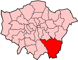
 Farnborough Location within Greater London | |
| Population | 14,632 (2011 Census. Farnborough and Crofton Ward)[1] |
| OS grid reference | TQ445645 |
| • Charing Cross | 13.4 mi (21.6 km) NW |
| London borough | |
| Ceremonial county | Greater London |
| Region | |
| Country | England |
| Sovereign state | United Kingdom |
| Post town | ORPINGTON |
| Postcode district | BR6 |
| Dialling code | 01689 |
| Police | Metropolitan |
| Fire | London |
| Ambulance | London |
| UK Parliament | |
| London Assembly | |
History
The village name derives from Fearnbiorginga, meaning village among the ferns on the hill. Old records date from 862 when Ethelbert, King of Wessex, gave away 950 acres at Farnborough. The village was not included in the Domesday Book survey, but the manor existed in the Middle Ages and was held in the 13th century by Simon de Montfort.[2]
The village evolved on the main road from London to Hastings which originally ran via Church Road and Old Hill (to the south of the village). The George pub existed in the 16th century and was used as a coaching inn. Coaches and horses were accommodated later.[2]
Farnborough formed a civil parish in the Ruxley hundred of Kent. In 1840 the parish was included in the Metropolitan Police District. It was part of the Bromley rural sanitary district and went on to form part of the Bromley Rural District from 1894 to 1934. The parish was abolished in 1934 as part of a county review order, following the Local Government Act 1929, and its area was split between the Municipal Borough of Bromley (3 acres) and Orpington Urban District (1,426 acres). The entire area has formed part of the London Borough of Bromley in Greater London since 1965.[3] The population of the parish was as follows:
| Year | 1801 | 1811 | 1821 | 1831 | 1841 | 1851 | 1861 | 1871 | 1881 | 1891 | 1901 | 1911 | 1921 | 1931 |
|---|---|---|---|---|---|---|---|---|---|---|---|---|---|---|
| Population[4] | 314 | 452 | 553 | 638 | 680 | 920 | 955 | 1,086 | 1,451 | 1,627 | 2,262 | 3,210 | 3,322 | 4,373 |
Transport
Rail
The nearest National Rail station to Farnborough is Orpington, located 1.7 miles away.
Buses
Farnborough is served by London Buses routes 358 & R4. These connect it with areas including Beckenham, Bromley, Crystal Palace, Orpington & Penge.
Nearby areas
Farnborough borders Locksbottom to the north west and north, Orpington to the north east, Green Street Green to the east and south east Hazelwood to the south, Downe to the south west, and Keston to the west.
References
- "Bromley Ward population 2011". Neighbourhood Statistics. Office for National Statistics. Retrieved 10 October 2016.
- "Farnborough Village Society". Farnboroughvillage.info. Archived from the original on 5 July 2007. Retrieved 26 July 2012.
- Great Britain Historical GIS / University of Portsmouth, Farnborough (historic map). Retrieved 2008-03-31.
- Great Britain Historical GIS / University of Portsmouth, Farnborough population. Retrieved 2008-03-31.