Locksbottom
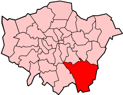
Locksbottom is a suburb of south east London within the London Borough of Bromley. It is located west of Orpington and south east of Bromley, in the historic county of Kent.
| Locksbottom | |
|---|---|
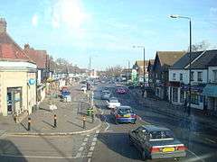
 Crofton Road in Locksbottom | |
 Locksbottom Location within Greater London | |
| OS grid reference | TQ435655 |
| London borough | |
| Ceremonial county | Greater London |
| Region | |
| Country | England |
| Sovereign state | United Kingdom |
| Post town | ORPINGTON |
| Postcode district | BR6 |
| Dialling code | 01689 |
| Police | Metropolitan |
| Fire | London |
| Ambulance | London |
| UK Parliament | |
| London Assembly | |
It consists of a parade of shops on Crofton Road running from the Fantail to Tugmutton Common. At one end is the Black Horse pub, with the Whyte Lion pub at the other. The major building in the area is a large Sainsbury's which backs onto the Princess Royal University Hospital. The hospital, which originally started as a workhouse infirmary in March 1845, developed into one of Bromley's main hospitals by the late 1990s.[1]
Locksbottom was famous in the 1970s for its Christmas lights displays and had many famous personalities switching on the lights, but over the last few years it has declined dramatically. Locksbottom has still maintained its village atmosphere, but has suffered with the increase of bigger local shopping complexes.
Transport
Rail
The nearest National Rail station to Locksbottom is Orpington station, located 1.8 miles away.
Buses
Locksbottom is served by London Buses routes 61, 261, 336, 353, 358, R2, R3 & R4. These connect it with areas including Biggin Hill, Beckenham, Bromley, Catford, Chislehurst, Crystal Palace, Grove Park, Hayes, Lewisham, Orpington & Penge.
Nearby Areas
Locksbottom borders Petts Wood to the north and north east, Orpington to the east and south east, Farnborough to the south and south west, Keston to the west and Bromley Common to the north west.
