Daintree Rainforest
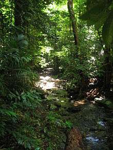
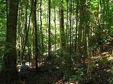
The Daintree Rainforest is a region on the northeast coast of Queensland, Australia, north of Mossman and Cairns. At around 1,200 square kilometres (460 sq mi),[1] the Daintree is a part of the largest continuous area of tropical rainforest on the Australian continent. The Daintree Rainforest is a part of the Wet Tropics of Queensland Rainforest, that spans across the Cairns Region. The Wet Tropics Rainforest (that the Daintree is a part of) is the oldest continually surviving tropical rainforest in the world. Along the coastline north of the Daintree River, tropical forest grows right down to the edge of the sea.[2]

In 2009 as part of the Q150 celebrations, the Daintree Rainforest was announced as one of the Q150 Icons of Queensland for its role as a "natural attraction".[3]
About Daintree Rainforest

The rainforest is named after Richard Daintree, an Australian geologist and photographer (1832–1878).
The area includes the Daintree National Park, some areas of State Forest, and some privately owned land, including a residential community of upwards of 5 people. Some of the privately owned land north of the Peninsula Range is being progressively purchased for conservation purposes under a $15 million government scheme involving equal contributions from the municipal (Cairns Regional Council), which includes the former Douglas Shire council), State (Queensland) and Australian Federal governments. As of May 2011, 72% of the properties earmarked for buyback or compensation had been secured. These 'buyback' areas of tropical rainforest included 215 blocks of land purchased by the Queensland Parks and Wildlife Service, and 13 purchased by private conservation agencies.[4][5] The Daintree Rainforest contains 30% of the frog, reptile and marsupial species in Australia, and 90% of Australia's bat and butterfly species. 7% of bird species in the country can be found in this area. There are also over 12,000 species of insects in the rainforest. All of this diversity is contained within an area that takes up 0.2% of the landmass of Australia. Part of the forest is protected by the Daintree National Park and drained by the Daintree River. The roads north of the river wind through areas of lush forest, and have been designed to minimize impacts on this new ecosystem.
Daintree Rainforest
The tropical rainforest ecosystem of the Daintree Rainforest is one of the most complex on Earth. Its plant diversity and structural complexity is unrivaled on the Australian continent and represents the origins of other Australian flora.
Millions of years ago, the Australian continent was warm and humid and rainfall was plentiful. During this time rainforest thrived in places such as the Uluru (Ayers Rock) region. As Australia became more arid, fewer and fewer places rainforests were able to survive. In the Daintree region, however, the climate and topography were ideal, so the area became a last remaining refuge for the rainforest. Within this refuge, many species were able to live comfortably without reason to change. Their descendants that are still living today retained many of their ancestors' primitive characteristics, some dating back 110 million years.
One species in particular, Idiospermum australiense, commonly known as the idiot fruit, is one of the rarest and most primitive of the flowering plants. Its discovery in 1970 was arguably Australia's most significant botanical find, greatly increasing scientists awareness of just how ancient these forests really are.
From a total of 19 primitive flowering plant families on Earth, 12 families are represented in the Daintree region making the highest concentration of these plants worldwide. These ancient plant families may be helpful for discerning the origins of the flowering plants.[6]
Exploring
.jpg)
The Daintree region combines tropical rainforest, white sandy beaches, and fringing reefs just offshore, which is a rare combination. Due to the distance between attractions, driving is the often the simplest way to navigate between them. The Daintree National Park boasts many walking tracks[7] and there are a number of accommodation options within the Daintree Rainforest itself.
To the west of Cape Tribulation stands Mt Pieter Botte with its massive granite outcrops. The summit providing expansive vistas of undisturbed forest and to the south, the skyline is dominated by the giant granite boulders of Thornton Peak – one of Queensland's highest mountains.[6]
Much of the Daintree Rainforest is part of the Wet Tropics of Queensland World Heritage Site, being listed by UNESCO in 2015 in recognition of its universal natural values highlighted by the rainforest.[8][9]
Amongst the attributes provided as evidence for the World Heritage value of the Wet Tropics, which include the Daintree Rainforest, the Australian Government[10] lists the following:
They preserve major stages of the earth's evolutionary history -
- ancient plants representing some of the earliest land plants, the Psilotopsida (whisk ferns) and the Lycopsida (club mosses or tassel ferns);
- 7 ancient families of true ferns, including the Marattiaceae (giant or king ferns), Osmundaceae (royal ferns), Schizaeaceae (comb ferns) and Gleicheniaceae (coral ferns);
- fern genera of East Gondwanan origins, including Polystichum (shield ferns), Leptopteris, Todea, Tmesipteris (fork ferns), Lycopodiella and Huperzia (club mosses and tassel ferns);
- the ancient, fern-like cycad Bowenia spectabilis (zamia fern) and other cycads including Cycas, and the giant Lepidozamia hopei (zamia palm);
- ancient conifers such as Podocarpus (plum pine or brown pine), Prumnopitys (brown pine or southern yew), Araucaria (hoop and bunya pines), and Agathis (kauri) which are living counterparts of Jurassic-age fossils (i.e., age of the dinosaurs);
- 12 primitive angiosperm (flowering plant) families, including small, primitive, relict angiosperm families such as Austrobaileyaceae, Idiospermaceae, Eupomatiaceae and Himantandraceae;
- relict angiosperm plant families that are known as fossils from the Cretaceous (last age of the dinosaurs) including Cunoniaceae, Proteaceae (banksia and macadamia family), Winteraceae, Myrtaceae (eucalypt and lilly pilly), Monimiaceae, Rutaceae, Sapindaceae, Aquifoliaceae (holly family), Chloranthaceae, Trimeniaceae, Epacridaceae (heath family), Olacaceae and families of angiosperms to represent the longest continuous history associated with the Gondwanan landmass.
They preserve unique, rare or superlative natural phenomena, formations or features of exceptional natural beauty –
- exceptional coastal scenery unusual in the world (and Australia) where tropical rainforest extends to white sandy beaches with fringing coral reefs just offshore;
- rugged mountain peaks and gorges with swiftly flowing rivers and spectacular waterfalls (e.g., Thornton Peak, Mossman Gorge, Roaring Meg Falls);
- extensive vistas of undisturbed forest and valleys.
The Daintree rainforest contains important and significant habitats for conservation of biological diversity. Approximately 430 species of birds live among the trees. The primitive flowering plants Austrobaileya scandens and Idiospermum australiense are also endemic to the Daintree. However, The Daintree Region is home to a number of rare and endangered species, including the southern cassowary (Casuarius Casuarius) and Bennett's tree-kangaroo (Dendrolagus bennettianus).
Daintree Important Bird Area
The Daintree Important Bird Area (IBA) is a 2656 km2 tract of land that largely coincides with the northernmost part of the Wet Tropics of Queensland World Heritage Site. It encompasses, or overlaps, the Black Mountain, Cedar Bay, Daintree, Mount Windsor and Mowbray National Parks.[11]
It has been identified as an IBA by BirdLife International because it supports a population of southern cassowaries. It also contains populations of the locally endemic tooth-billed and golden bowerbirds, lovely fairywrens, Macleay's, bridled, yellow-spotted and white-streaked honeyeaters, fernwrens, Atherton scrubwrens, mountain thornbills, chowchillas, Bower's shrike-thrushes, pied monarchs, Victoria's riflebirds and pale-yellow robins.[12]
References
- Daintree Discovery Centre. About The Daintree: "Archived copy". Archived from the original on 13 April 2014. Retrieved 29 March 2014.CS1 maint: archived copy as title (link)
- Russell, Rupert (1985) 'Where the Rainforest Meets the Reef - Our Last Paradise at Risk', Published by The evin Weldon & Australian Conservation Foundation; 1st edition
- Bligh, Anna (10 June 2009). "PREMIER UNVEILS QUEENSLAND'S 150 ICONS". Queensland Government. Archived from the original on 24 May 2017. Retrieved 24 May 2017.
- Daintree buyback. Cairns Regional Council. "Archived copy". Archived from the original on 22 April 2011. Retrieved 16 May 2011.CS1 maint: archived copy as title (link)
- Rainforest Rescue. Daintree Buy Back & Protect Forever project. "Archived copy". Archived from the original on 25 July 2011. Retrieved 16 May 2011.CS1 maint: archived copy as title (link)
- Daintree Discovery Centre. So What's so special about the Daintree?: "Archived copy". Archived from the original on 13 April 2014. Retrieved 29 March 2014.CS1 maint: archived copy as title (link)
- Science, jurisdiction=Queensland; sector=government; corporateName=Department of Environment and. "Daintree National Park". findapark.npsr.qld.gov.au. Retrieved 30 March 2018.
- Tisdell, C. and Wilson, C. World heritage listings of Australian natural sites: tourism stimulus and its economic value. Economic Analysis and Policy, Vol 32 (2).
- UNESCO Wet Tropics of Queensland: https://whc.unesco.org/en/list/486
- Wet Tropics of Queensland World Heritage: http://www.environment.gov.au/heritage/places/world/wet-tropics/index.html
- BirdLife International. (2011). Important Bird Areas factsheet: Daintree. Downloaded from "Archived copy". Archived from the original on 10 July 2007. Retrieved 4 May 2013.CS1 maint: archived copy as title (link) on 2011-12-17.
- "IBA: Daintree". Birdata. Birds Australia. Archived from the original on 6 July 2011. Retrieved 17 December 2011.
External links
| Wikimedia Commons has media related to Daintree Rainforest. |