Crisman, Colorado
Crisman is a census-designated place (CDP) in Boulder County, Colorado, United States. The population as of the 2010 Census was 186.[2]
Crisman, Colorado | |
|---|---|
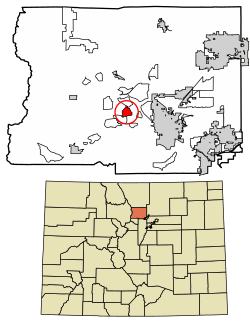 Location of Crisman in Boulder County, Colorado. | |
 Crisman Location of Crisman in Boulder County, Colorado. | |
| Coordinates: 40°2′24″N 105°21′40″W | |
| Country | |
| State | |
| County | Boulder[1] |
| Area | |
| • Total | 1.5 sq mi (3.8 km2) |
| • Land | 1.5 sq mi (3.8 km2) |
| • Water | 0 sq mi (0 km2) |
| Elevation | 6,301 ft (1,921 m) |
| Population (2010) | |
| • Total | 186 |
| • Density | 127/sq mi (49.1/km2) |
| Time zone | UTC-7 (MST) |
| • Summer (DST) | UTC-6 (MDT) |
| GNIS feature ID | 08-18585 |
History
Crisman was founded in 1874 as a mining camp and named after the adjacent Crisman Mill, an ore-processing mill owned by prospector and early settler Obed Crisman. Crisman became a boomtown in 1881, when the Yellow Pine Mine produced a massive silver strike. Crisman became a stop on the Greeley, Salt Lake and Pacific Railway. The Panic of 1893 and the subsequent crash of the silver market severely damaged Crisman's economy, although the nearby mines remained open for the duration. In 1894, Boulder Creek flooded, and much of the town was destroyed, including a section of railroad track. The obliterated structures were never rebuilt, and Crisman was significantly reduced in size. In 1901, the Logan Mine, a large gold operation near Crisman, uncovered a second strike, which prevented the town from disappearing altogether. By 1918, Crisman had become increasingly depopulated, and the post office closed that year. In 1919, another catastrophic flood swept through Fourmile Canyon, again destroying a section of railroad track and leaving little left of Crisman. The town has since been reduced to a hamlet.[3][4]
Geography
Crisman is located in central Boulder County in the Front Range of the Colorado Rocky Mountains, in the valley of Fourmile Creek. Four Mile Canyon Drive leads 7 miles (11 km) southeast to Boulder and 5 miles (8 km) northwest to Gold Hill.
According to the U.S. Census Bureau, the Crisman CDP has an area of 1.5 square miles (3.8 km2), all land.[5]
Demographics
| Historical population | |||
|---|---|---|---|
| Census | Pop. | %± | |
| U.S. Decennial Census[6] | |||
See also
- Outline of Colorado
- State of Colorado
- Colorado cities and towns
- Colorado census designated places
- Colorado counties
- Colorado metropolitan areas
- Front Range Urban Corridor
- North Central Colorado Urban Area
- Denver-Aurora-Boulder, CO Combined Statistical Area
- Boulder, CO Metropolitan Statistical Area
- Colorado cities and towns
References
- "US Board on Geographic Names". United States Geological Survey. 2007-10-25. Retrieved 2008-01-31.
- Colorado Trend Report 2: State and Complete Places (Sub-state 2010 Census Data). Archived 2012-07-11 at Archive.today Missouri Census Data Center. Accessed 2011-02-25.
- "Archived copy". Archived from the original on 2014-11-11. Retrieved 2014-11-11.CS1 maint: archived copy as title (link)
- http://www.ghosttowns.com/states/co/crisman.html
- "Geographic Identifiers: 2010 Demographic Profile Data (G001): Crisman CDP, Colorado". U.S. Census Bureau, American Factfinder. Archived from the original on February 12, 2020. Retrieved September 27, 2013.
- "Census of Population and Housing". Census.gov. Retrieved June 4, 2016.
| Wikimedia Commons has media related to Crisman, Colorado. |
Municipalities and communities of Boulder County, Colorado, United States | ||
|---|---|---|
| Cities | 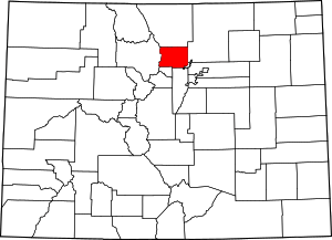 Map of Colorado highlighting Boulder County | |
| Towns | ||
| CDPs | ||
| Unincorporated communities | ||
| Ghost town | ||
| Footnotes | ‡This populated place also has portions in an adjacent county or counties | |