Paragon Estates, Colorado
Paragon Estates is a census-designated place (CDP) in Boulder County, Colorado, United States. The population as of the 2010 Census was 928.[2]
Paragon Estates, Colorado | |
|---|---|
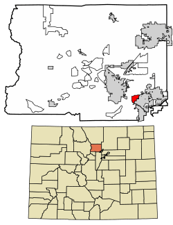 Location of Paragon Estates in Boulder County, Colorado. | |
 Paragon Estates Location of Paragon Estates in Boulder County, Colorado. | |
| Coordinates: 39°58′55″N 105°10′29″W | |
| Country | |
| State | |
| County | Boulder[1] |
| Area | |
| • Total | 1.7 sq mi (4.4 km2) |
| • Land | 1.7 sq mi (4.4 km2) |
| • Water | 0 sq mi (0 km2) |
| Elevation | 5,500 ft (1,700 m) |
| Population (2010) | |
| • Total | 928 |
| • Density | 545/sq mi (210.6/km2) |
| Time zone | UTC-7 (MST) |
| • Summer (DST) | UTC-6 (MDT) |
| GNIS feature ID | 08-57445 |
Geography
Paragon Estates is located in southeastern Boulder County on the northwest edge of Louisville and 6 miles (10 km) southeast of Boulder. U.S. Highway 36, the Denver–Boulder Turnpike, forms the southwest edge of the CDP.
According to the U.S. Census Bureau, the Paragon Estates CDP has an area of 1.7 square miles (4.4 km2), of which 0.012 square miles (0.03 km2), or 0.63%, is water.[3]
Demographics
| Historical population | |||
|---|---|---|---|
| Census | Pop. | %± | |
| U.S. Decennial Census[4] | |||
gollark: I mean, 0 and 1 are the first terms, sure...
gollark: No. I've vaguely read about recurrence relations and differential equations being related to matrices but don't know much.
gollark: Given that I just made people write 11 excellent matrix multiplication implementations as part of my plan, I wish to use this.
gollark: And how is this to be used for fibonnacious purposes? How does it *work*?
gollark: How do you do fibonacci with matrix multiplication?!?!?!?!
See also
- Outline of Colorado
- State of Colorado
- Colorado cities and towns
- Colorado census designated places
- Colorado counties
- Colorado metropolitan areas
- Front Range Urban Corridor
- North Central Colorado Urban Area
- Denver-Aurora-Boulder, CO Combined Statistical Area
- Boulder, CO Metropolitan Statistical Area
- Colorado cities and towns
References
- "US Board on Geographic Names". United States Geological Survey. 2007-10-25. Retrieved 2008-01-31.
- Colorado Trend Report 2: State and Complete Places (Sub-state 2010 Census Data). Missouri Census Data Center. Accessed 2011-02-25.
- "Geographic Identifiers: 2010 Demographic Profile Data (G001): Paragon Estates CDP, Colorado". U.S. Census Bureau, American Factfinder. Archived from the original on February 12, 2020. Retrieved October 18, 2013.
- "Census of Population and Housing". Census.gov. Retrieved June 4, 2016.
| Wikimedia Commons has media related to Paragon Estates, Colorado. |
Municipalities and communities of Boulder County, Colorado, United States | ||
|---|---|---|
| Cities | 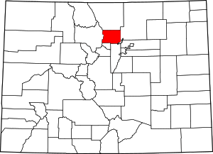 Map of Colorado highlighting Boulder County | |
| Towns | ||
| CDPs | ||
| Unincorporated communities | ||
| Ghost town | ||
| Footnotes | ‡This populated place also has portions in an adjacent county or counties | |
This article is issued from Wikipedia. The text is licensed under Creative Commons - Attribution - Sharealike. Additional terms may apply for the media files.