Valmont, Colorado
Valmont is a census-designated place (CDP) in Boulder County, Colorado, United States. The population as of the 2010 Census was 59.[2]
Valmont, Colorado | |
|---|---|
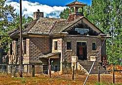 Valmont School, built in 1911 (2010 photo) | |
 Location of Valmont in Boulder County, Colorado. | |
 Valmont Location of Valmont in Boulder County, Colorado. | |
| Coordinates: 40°1′55″N 105°12′52″W | |
| Country | |
| State | |
| County | Boulder[1] |
| Area | |
| • Total | 0.3 sq mi (0.9 km2) |
| • Land | 0.3 sq mi (0.7 km2) |
| • Water | 0.08 sq mi (0.2 km2) |
| Elevation | 5,180 ft (1,580 m) |
| Population (2010) | |
| • Total | 59 |
| • Density | 221/sq mi (85.2/km2) |
| Time zone | UTC-7 (MST) |
| • Summer (DST) | UTC-6 (MDT) |
| GNIS feature ID | 08-80370 |
Valmont was platted in 1865, and named for the valleys and peaks near the town site.[3] A post office called Valmont was established in 1865, and remained in operation until 1901.[4]
Geography
Valmont is located in southeastern Boulder County, east of the city of Boulder, between Boulder Creek to the north and 200-foot-tall (60 m) Valmont Butte to the south. Valmont Road runs through the center of the community.
According to the U.S. Census Bureau, the Valmont CDP has an area of 0.35 square miles (0.9 km2), of which 0.27 square miles (0.7 km2) is land and 0.077 square miles (0.2 km2), or 23.63%, is water.[5]
Demographics
| Historical population | |||
|---|---|---|---|
| Census | Pop. | %± | |
| U.S. Decennial Census[6] | |||
gollark: Well, most of the post-2028 games support triple keyboard mode.
gollark: Some of the Emu War anime websites don't really work right on modern hardware because of weird import restrictons in NANDWay, which is very irritating.
gollark: It has basically the same effect.
gollark: Some of the current Emu War games actually came from the future through a bizarre time travel accident in 2081 or so, which makes the canons even more complex.
gollark: There are a bunch of websites with "canonical" timelines, but they all contradict each other because they focus on different mediums.
See also
- Outline of Colorado
- State of Colorado
- Colorado cities and towns
- Colorado census designated places
- Colorado counties
- Colorado metropolitan areas
- Front Range Urban Corridor
- North Central Colorado Urban Area
- Denver-Aurora-Boulder, CO Combined Statistical Area
- Boulder, CO Metropolitan Statistical Area
- Colorado cities and towns
References
- "US Board on Geographic Names". United States Geological Survey. 2007-10-25. Retrieved 2008-01-31.
- Colorado Trend Report 2: State and Complete Places (Sub-state 2010 Census Data). Archived 2012-07-11 at Archive.today Missouri Census Data Center. Accessed 2011-02-25.
- "Post offices". Jim Forte Postal History. Retrieved 11 July 2016.
- Dawson, John Frank. Place names in Colorado: why 700 communities were so named, 150 of Spanish or Indian origin. Denver, CO: The J. Frank Dawson Publishing Co. p. 50.
- "Geographic Identifiers: 2010 Demographic Profile Data (G001): Valmont CDP, Colorado". U.S. Census Bureau, American Factfinder. Archived from the original on February 12, 2020. Retrieved October 18, 2013.
- "Census of Population and Housing". Census.gov. Retrieved June 4, 2016.
| Wikimedia Commons has media related to Valmont, Colorado. |
Municipalities and communities of Boulder County, Colorado, United States | ||
|---|---|---|
| Cities | 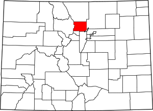 Map of Colorado highlighting Boulder County | |
| Towns | ||
| CDPs | ||
| Unincorporated communities | ||
| Ghost town | ||
| Footnotes | ‡This populated place also has portions in an adjacent county or counties | |
This article is issued from Wikipedia. The text is licensed under Creative Commons - Attribution - Sharealike. Additional terms may apply for the media files.