Sugarloaf, Colorado
Sugarloaf is a census-designated place (CDP) in Boulder County, Colorado, United States. The population as of the 2010 Census was 261.[2]
Sugarloaf, Colorado | |
|---|---|
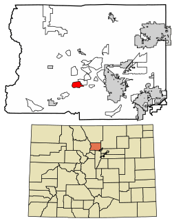 Location of Sugarloaf in Boulder County, Colorado. | |
 Sugarloaf Location of Sugarloaf in Boulder County, Colorado. | |
| Coordinates: 40°1′1″N 105°24′26″W | |
| Country | |
| State | |
| County | Boulder[1] |
| Area | |
| • Total | 2.2 sq mi (5.6 km2) |
| • Land | 2.2 sq mi (5.6 km2) |
| • Water | 0 sq mi (0 km2) |
| Elevation | 7,842 ft (2,390 m) |
| Population (2010) | |
| • Total | 261 |
| • Density | 120/sq mi (46.3/km2) |
| Time zone | UTC-7 (MST) |
| • Summer (DST) | UTC-6 (MDT) |
| GNIS feature ID | 08-74980 |
Geography
Sugarloaf is located in south-central Boulder County, approximately halfway between Boulder and Nederland. It is bordered by the Mountain Meadows CDP to the northeast, and North Boulder Creek forms part of the southern edge of the community. Sugarloaf Road is the main route through the CDP.
According to the U.S. Census Bureau, the Sugarloaf CDP has an area of 2.2 square miles (5.6 km2), all of it land.[3]
History
Sugarloaf, sometimes referred to as Sugar Loaf, Boulder County, was referred to in Colorado historical records dating back to 1868. It seems the early name came from a mining claim referred to as "Sugar Loaf, near Yellow Pine."[4] Sugar Loaf seems also to have been a term for a mining district, of multiple mining claims.[5]
In 1989, a destructive wildfire swept up and across much of Sugarloaf burning 2,100 acres (850 ha), destroying 44 houses and other structures, and causing approximately US$10 million in damages.[6] The Black Tiger Fire"was the worst wildland fire loss in Colorado history"[7] at the time. It was a human-caused fire that started 9 July 1989 in a scenic mountain area at the base of Black Tiger Gulch and swept up to the summit of Sugarloaf Mountain through residential areas that were "nestled among the trees. Within the first five to six hours after ignition, 44 homes and other structures were destroyed and many others were damaged."[7] Some fire fighters of the Sugarloaf Volunteer Fire Department had their own homes destroyed during the fire. Although there were a number of minor injuries, there were no fatalities from the fire.[7]
Town organizations and events
Sugarloaf has a volunteer fire department—as of 2019, the department typically runs 30 to 45 members—which is a part of the Sugar Loaf Fire Protection District (SLFPD) covering approximately 17 square miles (44 km2) of territory, 500 homes, with land between 6,000 to 8,500 ft (1,800 to 2,600 m) elevation in mountainous terrain. The VFD was initially formed in 1967,[9] and in 2019, serves approximately 1400 persons.[10][9]
See also
- Outline of Colorado
- State of Colorado
- Colorado cities and towns
- Colorado census designated places
- Colorado counties
- Colorado metropolitan areas
- Front Range Urban Corridor
- North Central Colorado Urban Area
- Denver-Aurora-Boulder, CO Combined Statistical Area
- Boulder, CO Metropolitan Statistical Area
- Colorado cities and towns
References
- "US Board on Geographic Names". United States Geological Survey. 2007-10-25. Retrieved 2008-01-31.
- Colorado Trend Report 2: State and Complete Places (Sub-state 2010 Census Data). Archived 2012-07-11 at Archive.today Missouri Census Data Center. Accessed 2011-02-25.
- "Geographic Identifiers: 2010 Demographic Profile Data (G001): Sugarloaf CDP, Colorado". U.S. Census Bureau, American Factfinder. Archived from the original on February 12, 2020. Retrieved October 18, 2013.
- The Real Pioneers of Colorado, Maria Davies McGrath, 1934. Retyped in 2001 to make available on the internet. Accessed 26 October 2019.
- https://cudl.colorado.edu/luna/servlet/detail/UCBOULDERCB1~85~85~1100589~141522:Sugar-Loaf-Mining-District
-
"The Black Tiger Fire". Disasters / Wildfires. Boulder County. Retrieved 2019-10-26.
The Black Tiger Fire occurred in 1989, in the foothills of Boulder County northwest of the City of Boulder. At the time, it was the most destructive wildfire in terms of property loss and damage in Colorado history. The fire burned almost 2,100 acres. 44 homes and other structures were destroyed and several others damaged. Loss estimates of homes and natural resources amounted to $10 million, and the cost to control the fire was another $1 million. More than 500 fire fighters from local, state and federal fire agencies worked to eventually contain the fire and protect the numerous other homes built in the rustic surroundings. Some of the fire fighters’ own homes were threatened or destroyed by the fire. Only a few minor fire fighter injuries were reported and one resident was hospitalized from burns.
- "Black Tiger Fire Case Study" (PDF). Fire investigations. NFPA fire investigations - Natural disasters. Quincy, Massachusetts: National Fire Protection Association. 1990.
- "Census of Population and Housing". Census.gov. Retrieved June 4, 2016.
- [https://www.slfpd.org/ SLFPD}}, accessed 27 October 2019}}
- https://www.timescall.com/2019/07/20/boulder-countys-rural-fire-stations-depend-on-volunteers-to-protect-communities/
| Wikimedia Commons has media related to Sugarloaf, Colorado. |
Municipalities and communities of Boulder County, Colorado, United States | ||
|---|---|---|
| Cities | 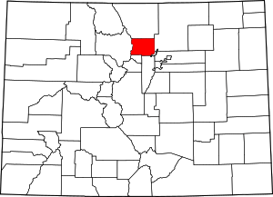 Map of Colorado highlighting Boulder County | |
| Towns | ||
| CDPs | ||
| Unincorporated communities | ||
| Ghost town | ||
| Footnotes | ‡This populated place also has portions in an adjacent county or counties | |