Bark Ranch, Colorado
Bark Ranch is a census-designated place (CDP) in Boulder County, Colorado, United States. The population as of the 2010 Census was 213.[2] It corresponds to the housing community of Bar-K Ranch.[3]
Bar-k Ranch, Colorado Bar-K Ranch | |
|---|---|
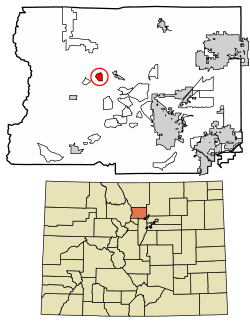 Location of Bark Ranch in Boulder County, Colorado. | |
 Bark Ranch Location of Bark Ranch in Boulder County, Colorado. | |
| Coordinates: 40°07′02″N 105°26′21″W | |
| Country | |
| State | |
| County | Boulder[1] |
| Area | |
| • Total | 0.87 sq mi (2.26 km2) |
| • Land | 0.86 sq mi (2.23 km2) |
| • Water | 0.008 sq mi (0.02 km2) |
| Elevation | 8,500 ft (2,600 m) |
| Population (2010) | |
| • Total | 213 |
| • Density | 247/sq mi (95.4/km2) |
| Time zone | UTC-7 (MST) |
| • Summer (DST) | UTC-6 (MDT) |
| GNIS feature ID | 08-04620 |
Geography
Bar-K Ranch is located in west central Boulder County in the Front Range of the Colorado Rocky Mountains. It is situated on a ridge west of Jamestown and south of South St. Vrain Creek. Overland Road forms the northern edge of the community, leading east to Jamestown and Altona and west to State Highway 72, the Peak to Peak Highway.
According to the U.S. Census Bureau, the Bark Ranch CDP has a total area of 0.89 square miles (2.3 km2), of which 0.008 square miles (0.02 km2), or 1.09%, is water.[4]
Demographics
| Historical population | |||
|---|---|---|---|
| Census | Pop. | %± | |
| U.S. Decennial Census[5] | |||
gollark: This "forum post" is... an interesting view into the world of malware development.
gollark: Was this *actually* designed by some random idiot on Discord? Hmmmm.
gollark: ...
gollark: How much of my random traffic are these responsible for?
gollark: Wait a minute, some of these strings look like the random PHP-exploity stuff in my webserver logs.
See also
- Outline of Colorado
- State of Colorado
- Colorado cities and towns
- Colorado census designated places
- Colorado counties
- Colorado metropolitan areas
- Front Range Urban Corridor
- North Central Colorado Urban Area
- Denver-Aurora-Boulder, CO Combined Statistical Area
- Boulder, CO Metropolitan Statistical Area
- Colorado cities and towns
References
- "US Board on Geographic Names". United States Geological Survey. 2007-10-25. Retrieved 2008-01-31.
- Colorado Trend Report 2: State and Complete Places (Sub-state 2010 Census Data). Archived 2012-07-11 at Archive.today Missouri Census Data Center. Accessed 2011-02-25.
- "About Us". Bar-K Ranch community page. Retrieved September 27, 2013.
- "Geographic Identifiers: 2010 Demographic Profile Data (G001): Bark Ranch CDP, Colorado". U.S. Census Bureau, American Factfinder. Archived from the original on February 12, 2020. Retrieved September 27, 2013.
- "Census of Population and Housing". Census.gov. Retrieved June 4, 2016.
External links
| Wikimedia Commons has media related to Bark Ranch, Colorado. |
Municipalities and communities of Boulder County, Colorado, United States | ||
|---|---|---|
| Cities | 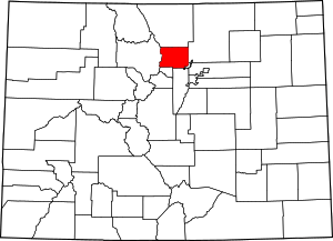 Map of Colorado highlighting Boulder County | |
| Towns | ||
| CDPs | ||
| Unincorporated communities | ||
| Ghost town | ||
| Footnotes | ‡This populated place also has portions in an adjacent county or counties | |
This article is issued from Wikipedia. The text is licensed under Creative Commons - Attribution - Sharealike. Additional terms may apply for the media files.