Chaillac
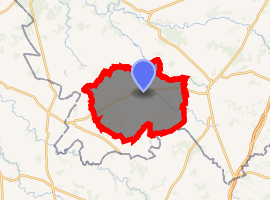
Chaillac (Limousin: Chalhac) is a commune in the Indre department in central France.
Chaillac | |
|---|---|
The place du Bosquet | |
.svg.png) Coat of arms | |
Location of Chaillac 
| |
 Chaillac  Chaillac | |
| Coordinates: 46°26′07″N 1°17′59″E | |
| Country | France |
| Region | Centre-Val de Loire |
| Department | Indre |
| Arrondissement | Le Blanc |
| Canton | Saint-Gaultier |
| Government | |
| • Mayor (2008–2014) | Gérard Mayaud |
| Area 1 | 59.79 km2 (23.09 sq mi) |
| Population (2017-01-01)[1] | 1,095 |
| • Density | 18/km2 (47/sq mi) |
| Time zone | UTC+01:00 (CET) |
| • Summer (DST) | UTC+02:00 (CEST) |
| INSEE/Postal code | 36035 /36310 |
| Elevation | 122–253 m (400–830 ft) (avg. 196 m or 643 ft) |
| 1 French Land Register data, which excludes lakes, ponds, glaciers > 1 km2 (0.386 sq mi or 247 acres) and river estuaries. | |
Geography
The commune is traversed by the river Anglin.
History
Château de Brosse, located on the old town of Brosse, was the possession of Viscount de Brosse, who were powerful in the Middle Ages, and even had their own mint in the eleventh century.[2] However, the village was created around the castle, located in a cul-de-sac, Chaillac was never completed, especially after being destroyed by the Anglo-Poitou in 1370.[3]
Population
| Year | Pop. | ±% |
|---|---|---|
| 1793 | 2,184 | — |
| 1800 | 2,412 | +10.4% |
| 1806 | 2,152 | −10.8% |
| 1821 | 2,515 | +16.9% |
| 1831 | 2,526 | +0.4% |
| 1836 | 2,595 | +2.7% |
| 1841 | 2,663 | +2.6% |
| 1846 | 2,714 | +1.9% |
| 1851 | 2,712 | −0.1% |
| 1856 | 2,660 | −1.9% |
| 1861 | 2,673 | +0.5% |
| 1866 | 2,643 | −1.1% |
| 1872 | 2,651 | +0.3% |
| 1876 | 2,657 | +0.2% |
| 1881 | 2,649 | −0.3% |
| 1886 | 2,697 | +1.8% |
| 1891 | 2,638 | −2.2% |
| 1896 | 2,603 | −1.3% |
| 1901 | 2,522 | −3.1% |
| 1906 | 2,464 | −2.3% |
| 1911 | 2,515 | +2.1% |
| 1921 | 2,105 | −16.3% |
| 1926 | 1,983 | −5.8% |
| 1931 | 1,926 | −2.9% |
| 1936 | 1,685 | −12.5% |
| 1946 | 1,619 | −3.9% |
| 1954 | 1,553 | −4.1% |
| 1962 | 1,453 | −6.4% |
| 1968 | 1,358 | −6.5% |
| 1975 | 1,253 | −7.7% |
| 1982 | 1,149 | −8.3% |
| 1990 | 1,246 | +8.4% |
| 1999 | 1,170 | −6.1% |
| 2009 | 1,136 | −2.9% |
gollark: I think it's pinned somewhere here.
gollark: Ah, it's on a calendar thing.
gollark: View depriver...?
gollark: Lunar heralds: Stupidly in demand.
gollark: Vue is a javascript library, too.
See also

References
- "Populations légales 2017". INSEE. Retrieved 6 January 2020.
- Archives of the department of Indre, Berry médiéval : à la découverte de l’Indre au Moyen Âge, exhibition catalog, Châteauroux, Archives of the department of Indre, 2009, p. 12.
- Berry médiéval, p. 54.
| Wikimedia Commons has media related to Chaillac. |
This article is issued from Wikipedia. The text is licensed under Creative Commons - Attribution - Sharealike. Additional terms may apply for the media files.