Le Pont-Chrétien-Chabenet
Le Pont-Chrétien-Chabenet is a commune in the Indre department in central France.
Le Pont-Chrétien-Chabenet | |
|---|---|
Oldest wooden covered bridge in France | |
.svg.png) Coat of arms | |
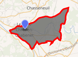
Location of Le Pont-Chrétien-Chabenet 
| |
 Le Pont-Chrétien-Chabenet  Le Pont-Chrétien-Chabenet | |
| Coordinates: 46°37′51″N 1°28′53″E | |
| Country | France |
| Region | Centre-Val de Loire |
| Department | Indre |
| Arrondissement | Châteauroux |
| Canton | Argenton-sur-Creuse |
| Intercommunality | Pays d'Argenton-sur-Creuse |
| Government | |
| • Mayor (2008–2014) | Yves Jaquet |
| Area 1 | 9.03 km2 (3.49 sq mi) |
| Population (2017-01-01)[1] | 925 |
| • Density | 100/km2 (270/sq mi) |
| Time zone | UTC+01:00 (CET) |
| • Summer (DST) | UTC+02:00 (CEST) |
| INSEE/Postal code | 36161 /36800 |
| Elevation | 96–178 m (315–584 ft) (avg. 100 m or 330 ft) |
| 1 French Land Register data, which excludes lakes, ponds, glaciers > 1 km2 (0.386 sq mi or 247 acres) and river estuaries. | |
Geography
The Bouzanne flows west through the northern part of the commune, then flows into the Creuse, which forms the commune's southwestern border.
Population
| Year | Pop. | ±% |
|---|---|---|
| 1921 | 703 | — |
| 1926 | 757 | +7.7% |
| 1931 | 687 | −9.2% |
| 1936 | 655 | −4.7% |
| 1946 | 703 | +7.3% |
| 1954 | 669 | −4.8% |
| 1962 | 669 | +0.0% |
| 1968 | 814 | +21.7% |
| 1975 | 813 | −0.1% |
| 1982 | 902 | +10.9% |
| 1990 | 879 | −2.5% |
| 1999 | 881 | +0.2% |
| 2009 | 961 | +9.1% |
Sights
- The oldest wooden covered bridge in France is in the commune.
gollark: https://blog.sentry.io/2017/12/06/strut-your-stuff/
gollark: |||||||||||||||||||||||||||||||||||||||||||||||||||||||||||||||||||||||||||||||||||||||||||||||||||||||||||||||||||||||||||||||||||||||||||||||| you.
gollark: ↓ Project ANTARCTIC OBSCURITY.
gollark: If you want fast, please install a Rust compiler.
gollark: The JS implementation is *not* fast.
See also
References
- "Populations légales 2017". INSEE. Retrieved 6 January 2020.
| Wikimedia Commons has media related to Le Pont-Chrétien-Chabenet. |
This article is issued from Wikipedia. The text is licensed under Creative Commons - Attribution - Sharealike. Additional terms may apply for the media files.