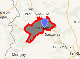
Fontgombault
Fontgombault is a commune in the Indre department in central France. It is known for its traditionalist Benedictine abbey.
Fontgombault | |
|---|---|
_-_%C3%89glise_Saint-Jacques_-_vue_arri%C3%A8re.jpg) The church of Saint-Jacques, in Fontgombault | |
Location of Fontgombault 
| |
 Fontgombault  Fontgombault | |
| Coordinates: 46°40′30″N 0°59′10″E | |
| Country | France |
| Region | Centre-Val de Loire |
| Department | Indre |
| Arrondissement | Le Blanc |
| Canton | Le Blanc |
| Intercommunality | Brenne Val de Creuse |
| Government | |
| • Mayor (2008–2014) | Jacques Tissier |
| Area 1 | 10.58 km2 (4.08 sq mi) |
| Population (2017-01-01)[1] | 249 |
| • Density | 24/km2 (61/sq mi) |
| Time zone | UTC+01:00 (CET) |
| • Summer (DST) | UTC+02:00 (CEST) |
| INSEE/Postal code | 36076 /36220 |
| Elevation | 67–136 m (220–446 ft) (avg. 111 m or 364 ft) |
| 1 French Land Register data, which excludes lakes, ponds, glaciers > 1 km2 (0.386 sq mi or 247 acres) and river estuaries. | |
Geography
The commune is located in the parc naturel régional de la Brenne.
Population
| Year | Pop. | ±% |
|---|---|---|
| 1793 | 495 | — |
| 1800 | 380 | −23.2% |
| 1806 | 365 | −3.9% |
| 1821 | 369 | +1.1% |
| 1831 | 392 | +6.2% |
| 1836 | 411 | +4.8% |
| 1841 | 368 | −10.5% |
| 1846 | 390 | +6.0% |
| 1851 | 428 | +9.7% |
| 1856 | 600 | +40.2% |
| 1861 | 569 | −5.2% |
| 1866 | 713 | +25.3% |
| 1872 | 781 | +9.5% |
| 1876 | 813 | +4.1% |
| 1881 | 420 | −48.3% |
| 1886 | 462 | +10.0% |
| 1891 | 450 | −2.6% |
| 1896 | 401 | −10.9% |
| 1901 | 383 | −4.5% |
| 1906 | 357 | −6.8% |
| 1911 | 411 | +15.1% |
| 1921 | 395 | −3.9% |
| 1926 | 481 | +21.8% |
| 1931 | 452 | −6.0% |
| 1936 | 488 | +8.0% |
| 1946 | 472 | −3.3% |
| 1954 | 324 | −31.4% |
| 1962 | 333 | +2.8% |
| 1968 | 324 | −2.7% |
| 1975 | 310 | −4.3% |
| 1982 | 267 | −13.9% |
| 1990 | 310 | +16.1% |
| 1999 | 283 | −8.7% |
| 2009 | 274 | −3.2% |
gollark: Of course not.
gollark: People accessing the remote debugging service connect on `potatOS` as admins. This requires a key with the right perms.
gollark: PotatOS devices listen on the `potatOS` channel as unprivileged clients.
gollark: Basically, access is divided into "channels".
gollark: Well, it uses a somewhat limited permission model.
See also
References
- "Populations légales 2017". INSEE. Retrieved 6 January 2020.
| Wikimedia Commons has media related to Fontgombault. |
This article is issued from Wikipedia. The text is licensed under Creative Commons - Attribution - Sharealike. Additional terms may apply for the media files.