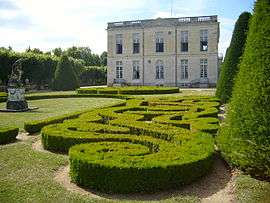
Bouges-le-Château
Bouges-le-Château is a commune in the Indre department in central France.
Bouges-le-Château | |
|---|---|
 | |
Location of Bouges-le-Château 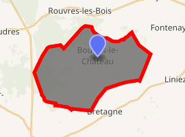
| |
 Bouges-le-Château  Bouges-le-Château | |
| Coordinates: 47°02′25″N 1°40′27″E | |
| Country | France |
| Region | Centre-Val de Loire |
| Department | Indre |
| Arrondissement | Châteauroux |
| Canton | Levroux |
| Government | |
| • Mayor (2010–2014) | Michel Brient |
| Area 1 | 34.77 km2 (13.42 sq mi) |
| Population (2017-01-01)[1] | 266 |
| • Density | 7.7/km2 (20/sq mi) |
| Time zone | UTC+01:00 (CET) |
| • Summer (DST) | UTC+02:00 (CEST) |
| INSEE/Postal code | 36023 /36110 |
| Elevation | 120–207 m (394–679 ft) (avg. 150 m or 490 ft) |
| 1 French Land Register data, which excludes lakes, ponds, glaciers > 1 km2 (0.386 sq mi or 247 acres) and river estuaries. | |
Population
| Year | Pop. | ±% |
|---|---|---|
| 1793 | 581 | — |
| 1800 | 600 | +3.3% |
| 1806 | 627 | +4.5% |
| 1821 | 691 | +10.2% |
| 1831 | 721 | +4.3% |
| 1836 | 736 | +2.1% |
| 1841 | 633 | −14.0% |
| 1846 | 680 | +7.4% |
| 1851 | 709 | +4.3% |
| 1856 | 964 | +36.0% |
| 1861 | 926 | −3.9% |
| 1866 | 1,023 | +10.5% |
| 1872 | 919 | −10.2% |
| 1876 | 908 | −1.2% |
| 1881 | 925 | +1.9% |
| 1886 | 905 | −2.2% |
| 1891 | 864 | −4.5% |
| 1896 | 849 | −1.7% |
| 1901 | 800 | −5.8% |
| 1906 | 832 | +4.0% |
| 1911 | 804 | −3.4% |
| 1921 | 712 | −11.4% |
| 1926 | 730 | +2.5% |
| 1931 | 704 | −3.6% |
| 1936 | 701 | −0.4% |
| 1946 | 635 | −9.4% |
| 1954 | 604 | −4.9% |
| 1962 | 588 | −2.6% |
| 1968 | 501 | −14.8% |
| 1975 | 402 | −19.8% |
| 1982 | 360 | −10.4% |
| 1990 | 308 | −14.4% |
| 1999 | 255 | −17.2% |
| 2009 | 281 | +10.2% |
gollark: No, it's a program.
gollark: `youtube-dl`
gollark: We must delete this person and everything they stood for.
gollark: Hi.
gollark: *What* under UV?
See also
References
- "Populations légales 2017". INSEE. Retrieved 6 January 2020.
| Wikimedia Commons has media related to Bouges-le-Château. |
| Authority control |
|
|---|
This article is issued from Wikipedia. The text is licensed under Creative Commons - Attribution - Sharealike. Additional terms may apply for the media files.