Aylesford railway station
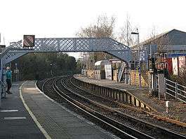
Aylesford railway station is on the Medway Valley Line in Kent, England, serving the village of Aylesford. It is 38 miles 74 chains (62.6 km) down the line from London Charing Cross via Strood and is situated between New Hythe and Maidstone Barracks. The station opened on 18 June 1856.
| Aylesford | |
|---|---|
 | |
| Location | |
| Place | Aylesford |
| Local authority | Tonbridge and Malling |
| Coordinates | 51°18′05″N 00°27′58″E |
| Grid reference | TQ720586 |
| Operations | |
| Station code | AYL |
| Managed by | Southeastern |
| Number of platforms | 2 |
| DfT category | F2 |
| Live arrivals/departures, station information and onward connections from National Rail Enquiries | |
| Annual rail passenger usage* | |
| 2014/15 | |
| 2015/16 | |
| 2016/17 | |
| 2017/18 | |
| 2018/19 | |
| History | |
| Key dates | Opened 18 June 1856 |
| National Rail – UK railway stations | |
| |
The station and all trains that call are operated by Southeastern.
History
Aylesford was opened by the South Eastern Railway, which merged with local rival London, Chatham and Dover Railway (LCDR) on 1 January 1899 to form the South Eastern and Chatham Railway (SECR). The station became part of the Southern Railway during the Grouping of 1923, and passed on to the Southern Region of British Railways on nationalisation in 1948.
When sectorisation was introduced in the 1980s, the station was served by Network SouthEast until the privatisation of British Railways.
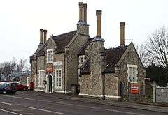
The ticket office, in a building on the northbound platform, closed in September 1989 and an Indian restaurant—now incorporating a fried chicken takeaway—was subsequently established in the building, which had been extensively renovated in a prizewinning scheme in 1988. In 2007, a PERTIS (Permit to Travel) ticket machine was installed just inside the entrance to the station, on the northbound platform.[1] In early 2016 the Permit to Travel machine was removed with plans to replace it with a ticket machine.
Services
The typical off-peak service from the station is two trains per hour to Maidstone West, with alternate trains extended to Paddock Wood and Tonbridge, and two trains an hour to Strood, for connections to London.
| Preceding station | Following station | |||
|---|---|---|---|---|
| New Hythe | Southeastern Medway Valley Line |
Maidstone Barracks | ||
Station Building

The section of the line surrounding Aylesford Station passes through what was part of the Preston Hall Estate, the then home of Edward Betts, the railway contractor who built this part of the Medway Valley Line. Consequently, the station building is much grander than other country stations along the line. The station buildings are gabled and highly decorated, built in Kentish ragstone with Caen stone dressings, in part reflecting a simplified version of the style of Preston Hall. Windows replicate those at Aylesford Priory.
Following restoration and refurbishment, the station building received an Ian Allan award in 2001, commemorated by a plaque in the waiting room/booking office, which is now in use as an Indian Takeaway Restaurant.
References
Notes
- Harman, David (ed.) (December 2007). The Journal of the Transport Ticket Society. Kemsing: The Transport Ticket Society (527): 451. ISSN 0144-347X. Missing or empty
|title=(help)CS1 maint: extra text: authors list (link)
Bibliography
- Butt, R. V. J. (1995). The Directory of Railway Stations: details every public and private passenger station, halt, platform and stopping place, past and present (1st ed.). Sparkford: Patrick Stephens Ltd. ISBN 978-1-85260-508-7. OCLC 60251199.
- Jowett, Alan (2000). Jowett's Nationalised Railway Atlas (1st ed.). Penryn, Cornwall: Atlantic Transport Publishers. ISBN 978-0-906899-99-1. OCLC 228266687.
- Jowett, Alan (March 1989). Jowett's Railway Atlas of Great Britain and Ireland: From Pre-Grouping to the Present Day (1st ed.). Sparkford: Patrick Stephens Ltd. ISBN 978-1-85260-086-0. OCLC 22311137.
- Station on navigable O.S. map
External links
| Wikimedia Commons has media related to Aylesford railway station. |
- Train times and station information for Aylesford railway station from National Rail
- Aylesford railway station in the 1866 edition of Bradshaw's Descriptive Railway Hand-Book of Great Britain & Ireland