Birchington-on-Sea railway station
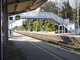
Birchington-on-Sea railway station is on the Chatham Main Line in England, serving the village of Birchington-on-Sea, Kent. It is 70 miles 56 chains (113.8 km) down the line from London Victoria and is situated between Herne Bay and Westgate-on-Sea.
| Birchington-on-Sea | |
|---|---|
 | |
| Location | |
| Place | Birchington-on-Sea |
| Local authority | District of Thanet |
| Coordinates | 51.377°N 1.301°E |
| Grid reference | TR298694 |
| Operations | |
| Station code | BCH |
| Managed by | Southeastern |
| Number of platforms | 2 |
| DfT category | E |
| Live arrivals/departures, station information and onward connections from National Rail Enquiries | |
| Annual rail passenger usage* | |
| 2014/15 | |
| 2015/16 | |
| 2016/17 | |
| 2017/18 | |
| 2018/19 | |
| History | |
| Original company | Kent Coast Railway |
| Pre-grouping | South Eastern and Chatham Railway |
| Post-grouping | Southern Railway |
| 5 October 1863 | Opened as Birchington |
| October 1878 | Renamed Birchington-on-Sea |
| National Rail – UK railway stations | |
| * Annual estimated passenger usage based on sales of tickets in stated financial year(s) which end or originate at Birchington-on-Sea from Office of Rail and Road statistics. Methodology may vary year on year. | |
The station and all trains that call are operated by Southeastern.
The station is located at one end of the high street and a short distance from the village square. Buses operate from the station to Minnis Bay and Margate on weekdays during peak hours; at other times buses can be caught from the village square.
History
The station was opened on 5 October 1863 by the Kent Coast Railway (KCR).[1] The KCR was operated by the London, Chatham and Dover Railway (LCDR), which absorbed the KCR on 1 July 1871,[2] and the station was renamed Birchington-on-Sea by the LCDR in October 1878.[1] From the start of 1899, the LCDR's services were operated by the newly formed South Eastern and Chatham Railway, which the LCDR co-owned with the South Eastern Railway (SER). At the start of 1923, the LCDR amalgamated with other railways (including the SER) to form the Southern Railway. Two Pullman camping coaches were positioned here by the Southern Region from 1963 to 1967.[3]
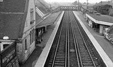
A small goods yard was situated on the Up London bound side of the station which closed in the 1970s and operated by the signalbox located midway on the down platform closed about the same time during a resignalling programme. The wire and rod cutout can still be seen within the brick face of the down platform. The 2007 Budget plan of Network Rail allows for the removal of the remaining manual turnround and it is believed short residual siding occasionally used for storing tamping track maintenance units, 'tampers'.

A junction existed to the west of the station to serve RAF Manston[4] until the 1930s operated from a Ground Frame Birchington B located some 440 yards (400 m) upside of the station - a plan of which can be seen in the RAF Manston Museum.
Services
- 1 tph to London St Pancras via Chatham and Ebbsfleet International (High Speed)
- 1 tph to London St Pancras via Ramsgate, Deal, Dover Priory, and Ashford International (High Speed)
- 1 tph to London Victoria via Chatham and Bromley South (Main Line)
- 1 tph to Ramsgate via Margate (Main Line)
| Preceding station | Following station | |||
|---|---|---|---|---|
| Herne Bay | Southeastern Chatham Main Line - Ramsgate Branch |
Westgate-on-Sea | ||
| Herne Bay | Southeastern High Speed 1 |
Margate | ||
References
- Butt, R.V.J. (1995). The Directory of Railway Stations. Yeovil: Patrick Stephens Ltd. p. 34. ISBN 1-85260-508-1. R508.CS1 maint: ref=harv (link)
- Awdry, Christopher (1990). Encyclopaedia of British Railway Companies. London: Guild Publishing. p. 189. CN 8983.CS1 maint: ref=harv (link)
- McRae, Andrew (1998). British Railways Camping Coach Holidays: A Tour of Britain in the 1950s and 1960s. Scenes from the Past: 30 (Part Two). Foxline. p. 59. ISBN 1-870119-53-3.
- McCarthy, Colin; McCarthy, David (October 2007). Waller, Peter (ed.). Railways of Britain: Kent and Sussex. Hersham: Ian Allan. map 8, section B5. ISBN 978-0-7110-3222-4. 0710/C1.CS1 maint: ref=harv (link)
External links
- Train times and station information for Birchington-on-Sea railway station from National Rail