Autonomous regions of China
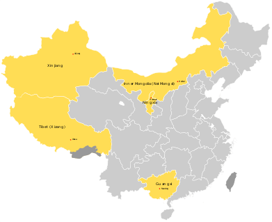
An autonomous region (AR; simplified Chinese: 自治区; traditional Chinese: 自治區; pinyin: zìzhìqū) is a first-level administrative division of China. Like Chinese provinces, an autonomous region has its own local government, but an autonomous region has more legislative rights. An autonomous region is the highest level of minority autonomous entity in China, which has a comparably higher population of a particular minority ethnic group.
| Autonomous region 自治区 Zìzhìqū | |
|---|---|
 | |
| Category | Unitary state |
| Location | |
| Number | 5 |
| Populations | 3,002,166 (Tibet Autonomous Region) – 46,026,629 (Guangxi) |
| Areas | 66,000 km2 (25,600 sq mi) (Ningxia) – 1,665,000 km2 (642,800 sq mi) (Xinjiang) |
| Government | Single-party government |
| Subdivisions | Prefecture-level city, Prefecture, League, Sub-Provincial Autonomous Prefecture, Autonomous Prefecture |
| This article is part of a series on |
| Administrative divisions of China |
|---|
|
|
|
Sub-prefectural-level |
|
Counties
Autonomous counties Banners (Hoxu) Wolong Special Administrative Region Workers and peasants districts |
|
Analogous county level units Management areas Management committee |
|
Townships
Ethnic townships Subdistricts Ethnic sum County-controlled districts (pilot) |
|
Analogous township level units Management areas Management committee Areas Farms area (Overseas Chinese Farm Region), Prison area, University towns etc. |
|
(Grassroots Autonomous Organizations)
Villages · Gaqa · Ranches Residential Committees |
|
Other |
|
History: before 1912, 1912–49, 1949–present Administrative division codes |
The Inner Mongolia Autonomous Region was established in 1947, Xinjiang was made autonomous in 1955, and Guangxi and Ningxia were made autonomous in 1958. Tibet was officially annexed in 1951, and was named a Chinese Autonomous Zone in 1965. The designation of Guangxi and Ningxia as Zhuang and Hui autonomous areas, respectively, was bitterly protested by the local Han Chinese, who made up two-thirds of the population of each region. Although Mongols made up an even smaller percentage of Inner Mongolia than either of these, the ensuing Chinese Civil War gave little opportunity for protest.[1]
List of autonomous regions
| Designated minority |
Name in English | Simplified Chinese Pinyin |
Local name SASM/GNC romanization (Language) |
Abbreviation | Capital | Language |
|---|---|---|---|---|---|---|
| Zhuang | Guangxi Zhuang Autonomous Region | 广西壮族自治区 Guǎngxī Zhuàngzú Zìzhìqū |
Gvangjsih Bouxcuengh Swcigih (Standard Zhuang/Zhuang) | 桂 Guì (GZAR) |
Nanning (南宁; Nanzningz) |
Zhuang, Standard Zhuang language (Vahcuengh) |
| Mongol | Inner Mongolia Autonomous Region (Nei Mongol Autonomous Region) |
内蒙古自治区 Nèi Měnggǔ Zìzhìqū |
ᠦᠪᠦᠷ ᠮᠣᠩᠭᠤᠯ ᠤᠨ ᠥᠪᠡᠷᠲᠡᠭᠡᠨ ᠵᠠᠰᠠᠬᠣ ᠣᠷᠣᠨ Öbür mongüol-un öbertegen zasaqu orun (Mongolian) |
内蒙古 Nèi Měnggǔ (IMAR) |
Hohhot (呼和浩特; ᠬᠥᠬᠡᠬᠣᠲᠠ) |
Mongolian |
| Tibetan | Tibet Autonomous Region Autonomous Region (Xizang Autonomous Region) |
西藏自治区 Xīzàng Zìzhìqū |
བོད་རང་སྐྱོང་ལྗོངས། Poi Ranggyong Jong (Standard Tibetan) |
藏 Zàng (TAR) |
Lhasa (拉萨; ལྷ་ས།) |
Standard Tibetan |
| Uyghur | Xinjiang Uyghur Autonomous Region | 新疆维吾尔自治区 Xīnjiāng Wéiwú'ěr Zìzhìqū |
شىنجاڭ ئۇيغۇر ئاپتونوم رايونى Xinjang Uyĝur Aptonom Rayoni (Uyghur) |
新 Xīn (XUAR) |
Ürümqi (乌鲁木齐; ئۈرۈمچی) |
Uyghur |
| Hui | Ningxia Hui Autonomous Region | 宁夏回族自治区 Níngxià Huízú Zìzhìqū |
The Hui speak Chinese | 宁 Níng (NHAR) |
Yinchuan (银川) |
Dungan, Chinese |
Statistics
Population
| Administrative Division | National Share (%) | 2010 Census[2] | 2000 Census[3] | 1990 Census[4] | 1982 Census[5] | 1964 Census[6] | 1954 Census[7] |
|---|---|---|---|---|---|---|---|
| Guangxi | 3.5 | 46,026,629 | 43,854,538 | 42,245,765 | 36,420,960 | 20,845,017 | 19,560,822 |
| Inner Mongolia | 1.9 | 24,706,321 | 23,323,347 | 21,456,798 | 19,274,279 | 12,348,638 | 6,100,104 |
| Ningxia | 0.5 | 6,176,900 | 5,486,393 | 4,655,451 | 3,895,578 | * | * |
| Tibet Autonomous Region | 0.2 | 3,002,166 | 2,616,329 | 2,196,010 | 1,892,393 | 1,251,225 | 1,273,969 |
| Xinjiang | 1.6 | 21,813,334 | 18,459,511 | 15,155,778 | 13,081,681 | 7,270,067 | 4,873,608 |
Ethnic composition of Autonomous Regions (%, 2000)
| Administrative Division | Titular Ethnic Group | Han Chinese | Third Largest Ethnic Group |
|---|---|---|---|
| Xinjiang (Uyghur) | 45.21% | 40.58% | 6.74% (Kazakh) |
| Tibet (Tibetan) | 92.8% | 6.1% | 0.35% (Hui) |
| Inner Mongolia (Mongol) | 17.13% | 79.17% | 2.14% (Manchu) |
| Ningxia (Hui) | 33.9% | 65.5 % | 1.16% (Manchu) |
| Guangxi (Zhuang) | 32.0% | 62.0 % | 3.0% (Yao) |
Note: In the "Third Largest Ethnic Group" column is the ethnic group given in brackets, after the names of the autonomous regions and Han people.
See also
References
| Wikimedia Commons has media related to Autonomous regions of China. |
- Dreyer, June Teufel (1997). "Assimilation and Accommodation in China". In Brown, Michael Edward; Ganguly, Šumit (eds.). Government Policies and Ethnic Relations in Asia and the Pacific. MIT Press. p. 365.
- "Communiqué of the National Bureau of Statistics of People's Republic of China on Major Figures of the 2010 Population Census". National Bureau of Statistics of China. Archived from the original on 2013-07-27.
- 现将2000年第五次全国人口普查快速汇总的人口地区分布数据公布如下. National Bureau of Statistics of China. Archived from the original on 2012-08-29.
- 中华人民共和国国家统计局关于一九九〇年人口普查主要数据的公报. National Bureau of Statistics of China. Archived from the original on 2012-06-19.
- 中华人民共和国国家统计局关于一九八二年人口普查主要数字的公报. National Bureau of Statistics of China. Archived from the original on 2012-05-10.
- 第二次全国人口普查结果的几项主要统计数字. National Bureau of Statistics of China. Archived from the original on 2012-09-14.
- 中华人民共和国国家统计局关于第一次全国人口调查登记结果的公报. National Bureau of Statistics of China. Archived from the original on 2009-08-05.
