Administrative divisions of Singapore
While the small physical size of the city-state does not qualify the creation of national subdivisions in the form of provinces, states, and other national political divisions found in larger countries, the city has nonetheless been administratively subdivided in various ways throughout its history for the purpose of local administration and urban planning.
History
Historically, these subdivisions have been based on postal districts, especially during the colonial era. When local elections necessitated the setting up of electoral districts, however, it began to supplement postal districts as an alternative form of local governance, since each electoral district is headed by a member of parliament who represents and speaks for the respective electorates.
Administrative and Electoral Divisions
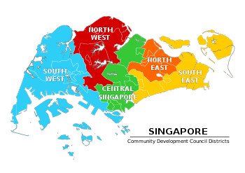
Community Development Council Districts
| Community Development Council Districts of Singapore | |
|---|---|
 | |
| Category | Unitary State |
| Location | Republic of Singapore |
| Created by | PA Act 1997 |
| Created | February 1997 [1] 11 November 2001 (Finalized) |
| Number | 5 districts (as of 2015) |
| Government | Community Development Council National Government |
| Subdivisions | Constituencies |
Established in 1997 by the PA Act, there were 9 districts formerly, governed by 9 different Community Development Councils (CDCs). In 2001, the 9 districts and CDCs were then reformed into 5, namely the North East CDC, North West CDC, South East CDC, South West CDC and Central Singapore CDC.[1][2] Each district is then further divided into electoral constituencies and town councils.
The council boundaries follow that of the existing political divisions, with each handling between four and six GRCs and SMCs and roughly dividing the country's population into equal parts. Each CDC is managed by a Council, which in turn is headed by a mayor and has between 12 and 80 members. The members are appointed by the Chairman or Deputy Chairman of the People's Association.
The role of the CDCs is to initiate, plan and manage community programmes to promote community bonding and social cohesion within local communities.[3] The electoral boundaries of Singapore are relatively fluid, and are reviewed prior to each general election. The districts are composed of the constituencies and electoral districts (the latter as of the 2015 General Elections).
There are currently five CDCs, namely the
Town councils
The first town councils were set up in September 1986 by the Town Councils Act, with the main purpose of estate management.[4] Prior to the introduction of town councils, housing estates were managed by the Housing Development Board.[5] As the estates were centrally managed, the standardised rules that the board had set for all housing estates made HDB towns monotonous in appearance and problems faced by residents in the different estates were not addressed fast enough.[5]
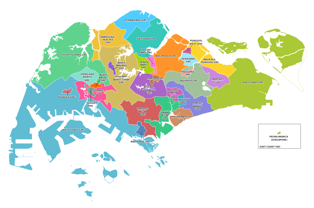
Town councils boundaries are drawn based on electoral district boundaries. A town council area can consist of a Group Representation Constituency (GRC), a Single Member Constituency (SMC), or a collection of neighbouring GRCs and SMCs controlled by the same political party. The Members of Parliament head the town councils of their constituencies. Town councils boundaries do not correspond to new town boundaries; different parts of the same HDB town may be managed by different town councils.[6]
There are currently 17 town councils as of 2020:[7]
| Town Council | Constituency |
|---|---|
| Aljunied–Hougang | Aljunied GRC |
| Hougang SMC | |
| Ang Mo Kio | Ang Mo Kio GRC |
| Kebun Baru SMC | |
| Yio Chu Kang SMC | |
| Bishan–Toa Payoh | Bishan–Toa Payoh GRC |
| Marymount SMC | |
| Chua Chu Kang | Chua Chu Kang GRC |
| Hong Kah North SMC | |
| East Coast | East Coast GRC |
| Holland–Bukit Panjang | Holland–Bukit Timah GRC |
| Bukit Panjang SMC | |
| Jalan Besar | Jalan Besar GRC |
| Potong Pasir SMC | |
| Jurong–Clementi | Jurong GRC |
| Bukit Batok SMC | |
| Yuhua SMC | |
| Marine Parade | Marine Parade GRC |
| MacPherson SMC | |
| Mountbatten SMC | |
| Marsiling–Yew Tee | Marsiling–Yew Tee GRC |
| Nee Soon | Nee Soon GRC |
| Pasir Ris–Punggol | Pasir Ris–Punggol GRC |
| Punggol West SMC | |
| Sembawang | Sembawang GRC |
| Sengkang | Sengkang GRC |
| Tampines | Tampines GRC |
| Tanjong Pagar | Tanjong Pagar GRC |
| Radin Mas SMC | |
| West Coast | West Coast GRC |
| Pioneer SMC |
Constituencies

Town councils are then further subdivided into different constituencies, which are classified as either Single Member Constituencies (SMCs) or Group Representation Constituencies (GRCs). The boundaries of the electoral constituencies are decided by the Elections Department, which is under the control of the Prime Minister's Office.[8]
Other administrative subdivisions
URA Master Plan boundaries
Regions
The regions are groupings of the planning areas.
Planning Areas
Regions are further subdivided into planning areas. In the 1990s, the Urban Redevelopment Authority carved up the country into 55 of these planning areas. Their boundaries became increasingly accepted as an alternative method of subdividing the country, made all the more popular as the boundaries do not change compared to the more fluid nature of electoral boundaries. The Singapore Department of Statistics adopted these boundaries for the latest 2000 nationwide population census, and the Singapore Police Force uses them as an approximate guide when demarcating boundaries for its Neighbourhood Police Centres, as opposed to the former Neighbourhood Police Post system which was also based on electoral divisions.
Survey Districts
Singapore is divided into 64 survey districts, of which 34 are mukims (originally, rural districts) and 30 are town subdivisions.[9]
Postal Districts
Postal districts were numbered from 01 to 83 under the new system implemented on 1 September 1995. Census data and most forms of internal boundaries had been based on postal districts until the introduction of new planning boundaries in the 1990s.
See also
References
- "Full map of CDCs released for first time". The Straits Times, p. 25 (Retrieved from Newspaper SG). 21 August 1997. Retrieved 19 August 2016.
- "First 2 CDCs preparing for launch". The Straits Times, p. 27. (Retrieved from Newspaper SG). 17 February 1997. Retrieved 19 August 2016.
- Fernandez, W. (19 August 1996). PM Goh urges young to rally behind him. The Straits Times, p. 1. Retrieved from NewspaperSG; The Straits Times, 19 Aug 1996, p. 24.
- Low, A. (1 September 1986). Town councils take over from HDB. .The Straits Times, p. 8. Retrieved from NewspaperSG.
- Ngoo, I., et al. (7 April 1987). My kind of town. The Straits Times, Retrieved from NewspaperSG; Koh, T., et al.
- Town Councils Act (Cap. 329A, 2000 Rev. Ed.)
- "Town Councils (Declaration) Order 2020". Singapore Statues Online. 29 July 2020.
- Alex Au Waipang, 'The Ardour of Tokens: Opposition Parties' Struggle to Make a Difference', in T.Chong (eds), Management of Success: Singapore Revisited (Singapore, 2010), p. 106.
- "Land Titles Search". Singapore Land Authority. Archived from the original on 1 November 2015. Retrieved 23 April 2016.
