Bilsby
Bilsby is a village and civil parish in the East Lindsey district of Lincolnshire, England. It lies on the main A1111 road between Alford and Sutton-on-Sea, 1 mile (1.6 km) east of Alford. Thurlby and Asserby are hamlets within Bilsby parish. According to the 2001 census, the parish had a population of 415,[1] which increased to 487 at the 2011 Census.[2]
| Bilsby | |
|---|---|
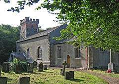
 Holy Trinity, Bilsby parish church | |
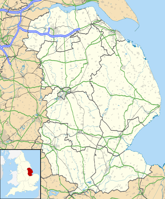
 Bilsby Location within Lincolnshire | |
| Population | 487 (including Farlesthorpe2011) |
| OS grid reference | TF473766 |
| • London | 120 mi (190 km) S |
| District | |
| Shire county | |
| Region | |
| Country | England |
| Sovereign state | United Kingdom |
| Post town | Alford |
| Postcode district | LN13 |
| Police | Lincolnshire |
| Fire | Lincolnshire |
| Ambulance | East Midlands |
| UK Parliament | |
History
Bilsby is mentioned in the Domesday Book of 1086 as a settlement of eighteen households.[3] The village name may derive from the Norse goddess Bil.[4]

Mumby Road railway station used to be situated here. In 1897, Thurlby would have been an important junction between the Sutton and Willoughby Railway (part of the East Lincolnshire Railway) and a proposed line from a new port at Sutton-on-Sea to another in Warrington to be built by the Lancashire, Derbyshire and East Coast Railway.[5]
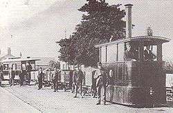
A steam tramway ran through Bilsby between 1884 and 1889. The Alford and Sutton Tramway[6] ran from Alford town to Sutton-on-Sea on rails set into the road; it opened in 1884 and closed only 5 years later.[7]
Landmarks

Bilsby church is dedicated to the Holy Trinity and is a Grade II* Listed Building,[8] dating from the 15th century. It was extensively repaired in 1841.[9] The church is stuccoed and has an 18th-century stone tower with brick battlements. The pulpit stem is the bole of a tree, with its steps cut from another.[10] A memorial slab in the chancel commemorates Sir John Byllesby (died 1640), a prominent figure in his day. His descendant, Major H. M. Byllesby (US Air Service), largely aided a restoration of the church in 1918.[9]
Built about 1740, Bilsby House is a mansion in the Georgian style occupying the site of an older moated and castellated house,[9] reputedly the residence of the Bilsby, sometimes spelt Billesby, family.[11] This family appear to have left the original mansion in 1616.[12]
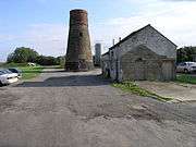
Built in 1861, Bilsby windmill was later extended; it was powered by wind and operated until 1932.[13] Although disused and missing its cap, the tower of the mill still stands and is a Grade II Listed Building.[14]
Thurlby and Asserby
Thurlby is mentioned in the Domesday Book as a settlement of 18 households.[15] Thurlby today is a hamlet in the parish of Bilsby, but in medieval times it was a parish in its own right and had a church dedicated to Saint Mary. No trace of the church remains today.[16]
As indicated by earthworks, the hamlet of Asserby is smaller today than the village it was in medieval times. Unlike Thurlby, it is not mentioned in the Domesday Book and did not have its own church.[17]
Population
| Population of Bilsby Civil Parish | ||||||||||||||||
|---|---|---|---|---|---|---|---|---|---|---|---|---|---|---|---|---|
| Year | 1801 | 1811 | 1821 | 1831 | 1841 | 1851 | 1881 | 1891 | 1901 | 1911 | 1921 | 1931 | 1951 | 1961 | 2001 | 2011 |
| Population[18] | 337 | 373 | 416 | 453 | 584 | 611 | 510 | 450 | 387 | 377 | 313 | 318 | 293 | 251 | 415 | 487 |
Geography
Sources
- Streatfield, George Sidney (1884). Lincolnshire and the Danes. K. Paul, Trench & Co.
References
- "Bilsby civil parish". Neighbourhood Statistics. Office for National Statistics. Retrieved 23 August 2011.
- "Parish population 2011". Archived from the original on 4 March 2016. Retrieved 18 August 2015.
- "Bilsby". Domesday Map. Anna Powell-Smith/University of Hull. Archived from the original on 7 October 2012. Retrieved 23 August 2011.
- Streatfield (1884:68)
- Lancashire, Derbyshire and East Coast Railway. Plans and sections. 1890. Lincolnshire Archive [LIND DEP PLANS 1/177.]
- "Alford & Sutton Tramway". Alford Website.
- "This Is Grimsby". Grimsby. Archived from the original on 13 September 2012. Retrieved 21 April 2011.
- Historic England. "Church of the Holy Trinity (Grade II*) (1360007)". National Heritage List for England. Retrieved 3 July 2018.
- "Kellys Directory". Kellys Directories Ltd. 1919. p. 66.
- Jack Yates & Henry Thorold (1965). Shell Guide To Lincolnshire. London Faber & Faber. p. 31.
- Post Office Directory of Lincolnshire. 1855. p. 27. Retrieved 22 April 2011.
- Arthur Roland Maddison (1891). "Lincolnshire Wills:with notes and introductory sketch". J Williamson. p. chapter XVI. Retrieved 22 April 2011.
- "This Is Grimsby". Archived from the original on 13 September 2012. Retrieved 21 April 2011.
- Historic England. "Windmill (Grade II) (1063005)". National Heritage List for England. Retrieved 3 July 2018.
- "Thurlby". Domesday Map. Anna Powell-Smith/University of Hull. Archived from the original on 7 October 2012. Retrieved 23 August 2011.
- "Lincs to the Past". Thurlby Deserted Medieval Village. Lincolnshire Archives. Retrieved 17 May 2011.
- "Lincs to the Past". Deserted Medieval Village of Asserby. Lincolnshire Archives. Retrieved 17 May 2011.
- "Vision of Britain". Retrieved 23 August 2011.
External links
![]()