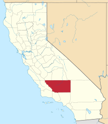
Asphalto, California
Asphalto is a former settlement in Kern County, California.[1] It was located on the railroad 3 miles (4.8 km) northeast of McKittrick,[2] at an elevation of 932 feet (284 m).[1] Asphalto still appeared on maps as of 1932.[1]
Asphalto | |
|---|---|
Former settlement | |
 Asphalto Location in California | |
| Coordinates: 35°18′17″N 119°36′03″W | |
| Country | United States |
| State | California |
| County | Kern County |
| Elevation | 932 ft (284 m) |
History
Originally the site of the Aguaje de La Brea a watering place on El Camino Viejo. The site has fossils in the asphalt deposits here, similar to other places in the vicinity of McKittrick.[3] A post office operated at Asphalto from 1893 to 1894, and from 1898 to 1900, when service was transferred to McKittrick.[2]
gollark: Just buy really long Ethernet cables, run them everywhere on the floors, and constantly trip over them.
gollark: Don't do wireless, kids.
gollark: Yes, since it uses 60GHz instead of 2.4 or 5.
gollark: It's annoying that despite having a giant radio spectrum to work with, WiFi is limited to some random smallish frequency bands because the government handles licensing weirdly.
gollark: It's 2.4GHz you potato.
References
- U.S. Geological Survey Geographic Names Information System: Asphalto, California
- Durham, David L. (1998). California's Geographic Names: A Gazetteer of Historic and Modern Names of the State. Clovis, Calif.: Word Dancer Press. p. 1070. ISBN 1-884995-14-4.
- William N. Abeloe, Mildred Brooke Hoover, H. E. Rensch, E. G. Rensch, Historic spots in California, 3rd Edition., Stanford University Press, Stanford, 1966 William N. Abeloe, Mildred Brooke Hoover, H. E. Rensch, E. G. Rensch, Historic spots in California, 3rd Edition., Stanford University Press, Stanford, 1966; p.128
This article is issued from Wikipedia. The text is licensed under Creative Commons - Attribution - Sharealike. Additional terms may apply for the media files.
