Arrondissement of Montluçon
The arrondissement of Montluçon is an arrondissement of France in the Allier department in the Auvergne-Rhône-Alpes region. It has 89 communes.[1] Its population is 108,364 (2016), and its area is 2,116.8 km2 (817.3 sq mi).[2]
Montluçon | |
|---|---|
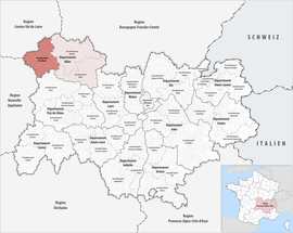 Location within the region Auvergne-Rhône-Alpes | |
| Country | France |
| Region | Auvergne-Rhône-Alpes |
| Department | Allier |
| No. of communes | 89 |
| Subprefecture | Montluçon |
| Area | |
| • Total | 2,116.8 km2 (817.3 sq mi) |
| Population (2016) | |
| • Total | 108,364 |
| • Density | 51/km2 (130/sq mi) |
| INSEE code | 031 |
Composition
The communes of the arrondissement of Montluçon, and their INSEE codes, are:[1]
- Ainay-le-Château (03003)
- Archignat (03005)
- Arpheuilles-Saint-Priest (03007)
- Audes (03010)
- Beaune-d'Allier (03020)
- Bézenet (03027)
- Bizeneuille (03031)
- Blomard (03032)
- Braize (03037)
- Le Brethon (03041)
- La Celle (03047)
- Cérilly (03048)
- Chambérat (03051)
- Chamblet (03052)
- La Chapelaude (03055)
- Chappes (03058)
- Chavenon (03070)
- Chazemais (03072)
- Colombier (03081)
- Commentry (03082)
- Cosne-d'Allier (03084)
- Courçais (03088)
- Deneuille-les-Mines (03097)
- Désertines (03098)
- Domérat (03101)
- Doyet (03104)
- Durdat-Larequille (03106)
- Estivareilles (03111)
- Haut-Bocage (03158)
- Hérisson (03127)
- Huriel (03128)
- Hyds (03129)
- Isle-et-Bardais (03130)
- Lamaids (03136)
- Lavault-Sainte-Anne (03140)
- Lételon (03143)
- Lignerolles (03145)
- Louroux-Bourbonnais (03150)
- Louroux-de-Beaune (03151)
- Malicorne (03159)
- Marcillat-en-Combraille (03161)
- Mazirat (03167)
- Meaulne-Vitray (03168)
- Mesples (03172)
- Montluçon (03185)
- Montmarault (03186)
- Montvicq (03189)
- Murat (03191)
- Nassigny (03193)
- Néris-les-Bains (03195)
- La Petite-Marche (03206)
- Prémilhat (03211)
- Quinssaines (03212)
- Reugny (03213)
- Ronnet (03216)
- Saint-Angel (03217)
- Saint-Bonnet-Tronçais (03221)
- Saint-Bonnet-de-Four (03219)
- Saint-Caprais (03222)
- Saint-Désiré (03225)
- Saint-Éloy-d'Allier (03228)
- Sainte-Thérence (03261)
- Saint-Fargeol (03231)
- Saint-Genest (03233)
- Saint-Marcel-en-Marcillat (03244)
- Saint-Marcel-en-Murat (03243)
- Saint-Martinien (03246)
- Saint-Palais (03249)
- Saint-Priest-en-Murat (03256)
- Saint-Sauvier (03259)
- Saint-Victor (03262)
- Sauvagny (03269)
- Sazeret (03270)
- Teillet-Argenty (03279)
- Terjat (03280)
- Theneuille (03282)
- Tortezais (03285)
- Treignat (03288)
- Urçay (03293)
- Valigny (03296)
- Vallon-en-Sully (03297)
- Vaux (03301)
- Venas (03303)
- Verneix (03305)
- Vernusse (03308)
- Le Vilhain (03313)
- Villebret (03314)
- Villefranche-d'Allier (03315)
- Viplaix (03317)
History
The arrondissement of Montluçon was created in 1800.[3] At the January 2017 reorganization of the arrondissements of Allier, it lost 14 communes to the arrondissement of Vichy.[4]
As a result of the reorganisation of the cantons of France which came into effect in 2015, the borders of the cantons are no longer related to the borders of the arrondissements. The cantons of the arrondissement of Montluçon were, as of January 2015:[5]
gollark: Compatible with almost all CC programs!
gollark: MicrOS leverages many BIOS/CraftOS features in order to retain its characteristic simplicity.
gollark: Other package managers are available and can be installed through pastebin.
gollark: MicrOS is simple to understand, easy to install, performant, efficient, and user-modifiable.
gollark: By CC standards, it's an OS, and arguably a good one, due to the lack of convoluted messes common in them.
References
- "Arrondissement de Montluçon (031)". INSEE. Retrieved 2019-09-26.
- "Comparateur de territoire, géographie au 01/01/2019". INSEE. Retrieved 2019-09-26.
- Historique de l'Allier
- "Arrêté n° 16-534, p 737" (PDF). Retrieved 2017-07-27.
- "Populations légales 2012" (PDF). INSEE. December 2014. Retrieved 2019-10-07.
| Authority control |
|
|---|
This article is issued from Wikipedia. The text is licensed under Creative Commons - Attribution - Sharealike. Additional terms may apply for the media files.