Alamo, Indiana
Alamo is a town in Ripley Township, Montgomery County, in the U.S. state of Indiana.[6] The population was 66 at the 2010 census.
Alamo, Indiana | |
|---|---|
 | |
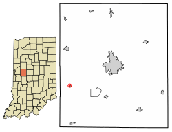 Location of Alamo in Montgomery County, Indiana. | |
 Alamo Alamo's location in Montgomery County | |
| Coordinates: 39°59′1″N 87°3′18″W | |
| Country | United States |
| State | Indiana |
| County | Montgomery |
| Township | Ripley |
| Area | |
| • Total | 0.06 sq mi (0.16 km2) |
| • Land | 0.06 sq mi (0.16 km2) |
| • Water | 0.00 sq mi (0.00 km2) |
| Elevation | 814 ft (248 m) |
| Population | |
| • Total | 66 |
| • Estimate (2019)[4] | 64 |
| • Density | 1,015.87/sq mi (390.41/km2) |
| Time zone | UTC−5 (Eastern (EST)) |
| • Summer (DST) | UTC−5 (EST) |
| ZIP code | 47916 |
| Area code | 765 |
| FIPS code[5] | 18-00784 |
| GNIS ID[5] | 430039 |
Geography
Alamo is located at 39°59′1″N 87°3′18″W (39.983709, -87.055078).[7]
According to the 2010 census, Alamo has a total area of 0.07 square miles (0.18 km2), all land.[8]
History
Alamo was laid out and platted in 1837.[9] It became a small trading center for nearby farms. In 1859 a road connected Alamo to Crawfordsville and the Yountsville Covered Bridge was built.[10] The town was named for the Alamo Mission in San Antonio, Texas.[11]
The post office at Alamo has been in operation since 1844.[12]
Demographics
| Historical population | |||
|---|---|---|---|
| Census | Pop. | %± | |
| 1880 | 220 | — | |
| 1890 | 272 | 23.6% | |
| 1900 | 241 | −11.4% | |
| 1910 | 209 | −13.3% | |
| 1920 | 167 | −20.1% | |
| 1930 | 163 | −2.4% | |
| 1940 | 155 | −4.9% | |
| 1950 | 163 | 5.2% | |
| 1960 | 144 | −11.7% | |
| 1970 | 145 | 0.7% | |
| 1980 | 178 | 22.8% | |
| 1990 | 112 | −37.1% | |
| 2000 | 137 | 22.3% | |
| 2010 | 66 | −51.8% | |
| Est. 2019 | 64 | [4] | −3.0% |
| U.S. Decennial Census[13] | |||
2010 census
As of the 2010 Census,[3] there were 66 people, 26 households, and 17 families living in the town. The population density was 942.9 inhabitants per square mile (364.1/km2). There were 39 housing units at an average density of 557.1 per square mile (215.1/km2). The racial makeup of the town was 89.4% White, 3.0% Native American, 6.1% from other races, and 1.5% from two or more races. Hispanic or Latino of any race were 6.1% of the population.
There were 26 households, of which 30.8% had children under the age of 18 living with them, 42.3% were married couples living together, 15.4% had a female householder with no husband present, 7.7% had a male householder with no wife present, and 34.6% were non-families. 26.9% of all households were made up of individuals, and 19.2% had someone living alone who was 65 years of age or older. The average household size was 2.54 and the average family size was 3.00.
The median age in the town was 36.7 years. 24.2% of residents were under the age of 18; 13.6% were between the ages of 18 and 24; 30.3% were from 25 to 44; 21.1% were from 45 to 64; and 10.6% were 65 years of age or older. The gender makeup of the town was 45.5% male and 54.5% female.
2000 census
As of the 2000 Census,[14] there were 137 people, 46 households, and 32 families living in the town. The population density was 2,388.6 people per square mile (881.6/km2). There were 53 housing units at an average density of 924.0 per square mile (341.1/km2). The racial makeup of the town was 89.05% White, 1.46% African American, 0.73% Native American, 1.46% from other races, and 7.30% from two or more races. Hispanic or Latino of any race were 1.46% of the population.
There were 46 households, out of which 45.7% had children under the age of 18 living with them, 47.8% were married couples living together, 17.4% had a female householder with no husband present, and 28.3% were non-families. 28.3% of all households were made up of individuals, and 13.0% had someone living alone who was 65 years of age or older. The average household size was 2.98 and the average family size was 3.64.
In the town, the population was spread out, with 38.0% under the age of 18, 5.8% from 18 to 24, 28.5% from 25 to 44, 16.8% from 45 to 64, and 10.9% who were 65 years of age or older. The median age was 28 years. For every 100 females, there were 95.7 males. For every 100 females age 18 and over, there were 97.7 males.
The median income for a household in the town was $17,500, and the median income for a family was $19,583. Males had a median income of $32,813 versus $23,750 for females. The per capita income for the town was $8,800. There were 30.3% of families and 29.6% of the population living below the poverty line, including 42.6% of under eighteens and none of those over 64.
Education
South Montgomery Community School Corporation operates public schools serving Alamo. Southmont Junior High School and Southmont High School serve secondary students.[15]
Organizations
There are three main not-for-profit organizations in Alamo.
The Alamo Christian Church, Kevin Howey, Minister
Ripley Township Fire Department
Masonic Lodge No. 144
References
- "2019 U.S. Gazetteer Files". United States Census Bureau. Retrieved July 16, 2020.
- "US Board on Geographic Names". United States Geological Survey. October 25, 2007. Retrieved 2017-05-09.
- "U.S. Census website". United States Census Bureau. Retrieved 2012-12-11.
- "Population and Housing Unit Estimates". United States Census Bureau. May 24, 2020. Retrieved May 27, 2020.
- "FIPS55 Data: Indiana". FIPS55 Data. United States Geological Survey. February 23, 2006. Archived from the original on June 18, 2006. Retrieved June 28, 2014.
- "Alamo, Indiana". Geographic Names Information System. United States Geological Survey. Retrieved 2017-06-10.
- "US Gazetteer files: 2010, 2000, and 1990". United States Census Bureau. 2011-02-12. Retrieved 2011-04-23.
- "G001 - Geographic Identifiers - 2010 Census Summary File 1". United States Census Bureau. Archived from the original on 2020-02-13. Retrieved 2015-07-13.
- Beckwith, Hiram Williams; Kennedy, P. S. (1881). History of Montgomery County, Together with Historic Notes on the Wabash Valley. H. H. Hill and N. Iddings. p. 585.
- Gronert, Theodore G., Sugar Creek Saga: A History and Development of Montgomery County, Wabash College, 1958. Pg 51-53
- Baker, Ronald L. (October 1995). From Needmore to Prosperity: Hoosier Place Names in Folklore and History. Indiana University Press. p. 47. ISBN 978-0-253-32866-3.
The name comes from the fort in San Antonio, Texas.
- "Montgomery County". Jim Forte Postal History. Retrieved June 10, 2017.
- "Census of Population and Housing". Census.gov. Retrieved June 4, 2015.
- "U.S. Census website". United States Census Bureau. Retrieved 2008-01-31.
- "SCHOOL DISTRICT REFERENCE MAP (2010 CENSUS): Montgomery County, IN." U.S. Census Bureau. Retrieved on November 26, 2016.
Municipalities and communities of Montgomery County, Indiana, United States | ||
|---|---|---|
| City | Map of Indiana highlighting Montgomery County | |
| Towns | ||
| Townships | ||
| CDP | ||
| Other unincorporated communities | ||
| Footnotes | ‡This populated place also has portions in an adjacent county or counties | |