Mazeley
Mazeley is a commune in the Vosges department in Grand Est in northeastern France.
Mazeley | |
|---|---|
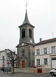 The church in Mazeley | |
Location of Mazeley 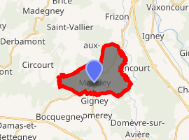
| |
 Mazeley  Mazeley | |
| Coordinates: 48°14′34″N 6°20′22″E | |
| Country | France |
| Region | Grand Est |
| Department | Vosges |
| Arrondissement | Épinal |
| Canton | Golbey |
| Intercommunality | CA Épinal |
| Government | |
| • Mayor (2008–2014) | Jean-Pierre Caytel |
| Area 1 | 10.39 km2 (4.01 sq mi) |
| Population (2017-01-01)[1] | 267 |
| • Density | 26/km2 (67/sq mi) |
| Time zone | UTC+01:00 (CET) |
| • Summer (DST) | UTC+02:00 (CEST) |
| INSEE/Postal code | 88294 /88150 |
| Elevation | 320–415 m (1,050–1,362 ft) |
| 1 French Land Register data, which excludes lakes, ponds, glaciers > 1 km2 (0.386 sq mi or 247 acres) and river estuaries. | |
Geography
The village lies at the junction of three or four minor roads some 10 kilometres (6 mi) northwest of Épinal.
History
Several archaeological discoveries indicate that the area was occupied in Roman times. A section of paved roadway was unearthed in the local woods in 1861, followed in 1988 by the discovery of a Gallo-Roman road in the Chanot district. Also discovered in 1988 an old road visible over more than a kilometre in an area called Donzey Wood (Bois de Donzey) heading in the direction of Gigney [2]
Points of interest
See also
References
- "Populations légales 2017". INSEE. Retrieved 6 January 2020.
- Provost (sous direction de), Michel (1988). Carte Archéologique de la Gaule. Vol 88. Paris: Académie des Inscriptions et Belles-Lettres. ISBN 2-87754-088-X.
| Wikimedia Commons has media related to Mazeley. |
| Authority control |
|
|---|
This article is issued from Wikipedia. The text is licensed under Creative Commons - Attribution - Sharealike. Additional terms may apply for the media files.