Maxey-sur-Meuse
Maxey-sur-Meuse is a commune in the Vosges department in Grand Est in northeastern France.
Maxey-sur-Meuse | |
|---|---|
 The town hall in Maxey-sur-Meuse | |
Location of Maxey-sur-Meuse 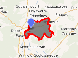
| |
 Maxey-sur-Meuse  Maxey-sur-Meuse | |
| Coordinates: 48°27′06″N 5°41′54″E | |
| Country | France |
| Region | Grand Est |
| Department | Vosges |
| Arrondissement | Neufchâteau |
| Canton | Neufchâteau |
| Intercommunality | CC Ouest Vosgien |
| Government | |
| • Mayor (2001–2008–2014) | Claude Fauvet |
| Area 1 | 10.77 km2 (4.16 sq mi) |
| Population (2017-01-01)[1] | 227 |
| • Density | 21/km2 (55/sq mi) |
| Time zone | UTC+01:00 (CET) |
| • Summer (DST) | UTC+02:00 (CEST) |
| INSEE/Postal code | 88293 /88630 |
| Elevation | 265–428 m (869–1,404 ft) (avg. 269 m or 883 ft) |
| 1 French Land Register data, which excludes lakes, ponds, glaciers > 1 km2 (0.386 sq mi or 247 acres) and river estuaries. | |
Confusingly, the similarly named commune of Maxey-sur-Vaise in the adjacent Meuse département is only 10 kilometres (6 mi) away, to the north.
Geography
Maxey-sur-Meuse is positioned in the north-west of the Vosges département, on the departmental frontier with the Meuse département. Neufchâteau is 13 kilometres (8 mi) away to the south. To the north east are Toul (34 kilometres / 21 miles) and Nancy (51 kilometres / 33 miles). Maxey is across the river from a road junction where traffic bound for Commercy continues in a northerly direction (RD964) while traffic for Bar-le-Duc turns to the north-west (RD966)
The (here relatively small) Meuse River flows through Maxey where it is joined by the waters from the Vair River and three smaller streams, the Roises, the Vau and the Blanchonrupt. The presence of all these water courses makes the village popular with anglers.
See also
References
- "Populations légales 2017". INSEE. Retrieved 6 January 2020.
| Wikimedia Commons has media related to Maxey-sur-Meuse. |
| Authority control |
|
|---|