Fountain Hill, Pennsylvania
Fountain Hill is a borough in Lehigh County, Pennsylvania, United States. It is a suburb of Bethlehem, Pennsylvania in the Lehigh Valley region of the state. Fountain Hill is included in the Allentown-Bethlehem-Easton, PA-NJ Metropolitan Statistical Area, which is also included in the New York City-Newark, New Jersey, NY-NJ-CT-PA Combined Statistical Area.
Borough of Fountain Hill | |
|---|---|
 Historic Lipps & Sutton Silk Mill, corner of Seneca and Clewell Sts. | |
 Location of Fountain Hill in Lehigh County, Pennsylvania. | |
 Fountain Hill Location of Fountain Hill in Pennsylvania  Fountain Hill Fountain Hill (the United States) | |
| Coordinates: 40°36′03″N 75°23′47″W | |
| Country | United States |
| State | Pennsylvania |
| County | Lehigh |
| Government | |
| • Mayor | Carolee Gifford |
| Area | |
| • Total | 0.75 sq mi (1.95 km2) |
| • Land | 0.73 sq mi (1.90 km2) |
| • Water | 0.02 sq mi (0.05 km2) |
| Elevation | 364 ft (111 m) |
| Population (2010) | |
| • Total | 4,597 |
| • Estimate (2019)[2] | 4,699 |
| • Density | 6,393.20/sq mi (2,467.16/km2) |
| Time zone | UTC-5 (EST) |
| • Summer (DST) | UTC-4 (EDT) |
| ZIP code | 18015 |
| Area code(s) | 610 and 484 |
| FIPS code | 42-27008 |
| Website | www |
The population of Fountain Hill was 4,597 at the 2010 census.
Geography
Fountain Hill is located at 40°36′6″N 75°23′47″W (40.601698, -75.396357).[3]
According to the United States Census Bureau, the borough has a total area of 0.7 square miles (1.8 km2), of which, 0.7 square miles (1.8 km2) of it is land and 1.41% is water. The Borough is approximately 450 acres (1.8 km2), predominantly residential in character, with approximately 1,754 dwelling units. It uses the Bethlehem ZIP code of 18015.
Demographics
| Historical population | |||
|---|---|---|---|
| Census | Pop. | %± | |
| 1900 | 1,214 | — | |
| 1910 | 1,388 | 14.3% | |
| 1920 | 2,339 | 68.5% | |
| 1930 | 4,568 | 95.3% | |
| 1940 | 4,804 | 5.2% | |
| 1950 | 5,456 | 13.6% | |
| 1960 | 5,428 | −0.5% | |
| 1970 | 5,384 | −0.8% | |
| 1980 | 4,805 | −10.8% | |
| 1990 | 4,637 | −3.5% | |
| 2000 | 4,614 | −0.5% | |
| 2010 | 4,597 | −0.4% | |
| Est. 2019 | 4,699 | [2] | 2.2% |
| Sources:[4][5][6] | |||
As of the census[5] of 2010, there were 4,597 people living in the borough. The racial makeup of the borough was 81.4% White, 6.6% African American, 0.1% Native American, 0.8% Asian, 0.0% Pacific Islander, 7.7% from other races, and 3.4% from two or more races. Hispanic or Latino of any race were 22.5% of the population.
As of the census[5] of 2000, there were 4,614 people, 1,911 households, and 1,125 families living in the borough. The population density was 6,542.8 people per square mile (2,509.1/km²). There were 2,029 housing units at an average density of 2,877.2 per square mile (1,103.4/km²). The racial makeup of the borough was 86.84% White, 3.81% African American, 0.20% Native American, 0.91% Asian, 6.00% from other races, and 2.23% from two or more races. Hispanic or Latino of any race were 10.73% of the population.
There were 1,911 households, out of which 26.3% had children under the age of 18 living with them, 43.8% were married couples living together, 11.9% had a female householder with no husband present, and 41.1% were non-families. 35.7% of all households were made up of individuals, and 14.5% had someone living alone who was 65 years of age or older. The average household size was 2.28 and the average family size was 2.99.
In the borough the population was spread out, with 21.7% under the age of 18, 7.3% from 18 to 24, 29.0% from 25 to 44, 21.0% from 45 to 64, and 21.0% who were 65 years of age or older. The median age was 40 years. For every 100 females there were 84.0 males. For every 100 females age 18 and over, there were 78.9 males.
The median income for a household in the borough was $40,318, and the median income for a family was $46,336. Males had a median income of $34,808 versus $26,537 for females. The per capita income for the borough was $18,508. About 7.5% of families and 8.9% of the population were below the poverty line, including 13.1% of those under age 18 and 5.1% of those age 65 or over.
Education
The Borough is served by the Bethlehem Area School District. John Spirk Elementary, also known as Fountain Hill Elementary School, is the neighborhood public school in the Borough.
Notable people
- Stephen Vincent Benét, author
- Joseph F. Brennan, State Representative, 133rd district (Ret.)
- Edwin Drake, discoverer of crude oil in Titusville PA, lived and died in Fountain Hill
- T. J. Rooney, State Representative, 133rd district (Ret.)
References
- "2019 U.S. Gazetteer Files". United States Census Bureau. Retrieved July 28, 2020.
- "Population and Housing Unit Estimates". United States Census Bureau. May 24, 2020. Retrieved May 27, 2020.
- "US Gazetteer files: 2010, 2000, and 1990". United States Census Bureau. 2011-02-12. Retrieved 2011-04-23.
- "Census of Population and Housing". U.S. Census Bureau. Retrieved 11 December 2013.
- "U.S. Census website". United States Census Bureau. Retrieved 2008-01-31.
- "Incorporated Places and Minor Civil Divisions Datasets: Subcounty Resident Population Estimates: April 1, 2010 to July 1, 2012". Population Estimates. U.S. Census Bureau. Archived from the original on 11 June 2013. Retrieved 11 December 2013.
External links
Places adjacent to Fountain Hill, Pennsylvania | |
|---|---|
| Wikimedia Commons has media related to Fountain Hill, Pennsylvania. |
Municipalities and communities of Lehigh County, Pennsylvania, United States | ||
|---|---|---|
| Cities | 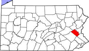 | |
| Boroughs | ||
| Townships |
| |
| CDPs | ||
| Unincorporated communities |
| |
| Footnotes | ‡This populated place also has portions in an adjacent county or counties | |
| Authority control |
|
|---|