Alburtis, Pennsylvania
Alburtis is a borough in Lehigh County, Pennsylvania, in the United States. It is a suburb of Allentown, in the Lehigh Valley region of the state. Alburtis is included in the Allentown-Bethlehem-Easton, PA-NJ Metropolitan Statistical Area, which is also included in the New York City-Newark, New Jersey, NY-NJ-CT-PA Combined Statistical Area.
Alburtis, Pennsylvania | |
|---|---|
 | |
 Location of Alburtis in Lehigh County, Pennsylvania. | |
 Alburtis Location of Alburtis in Pennsylvania  Alburtis Alburtis (the United States) | |
| Coordinates: 40°30′36″N 75°36′07″W | |
| Country | United States |
| State | Pennsylvania |
| County | Lehigh |
| Area | |
| • Total | 0.71 sq mi (1.83 km2) |
| • Land | 0.71 sq mi (1.83 km2) |
| • Water | 0.00 sq mi (0.00 km2) |
| Elevation | 472 ft (144 m) |
| Population (2010) | |
| • Total | 2,361 |
| • Estimate (2019)[2] | 2,636 |
| • Density | 3,728.43/sq mi (1,439.70/km2) |
| Time zone | UTC-5 (EST) |
| • Summer (DST) | UTC-4 (EDT) |
| ZIP Code | 18011 |
| Area code(s) | 610 |
| FIPS code | 42-00660 |
| Website | http://www.alburtis.org |
The population of Alburtis was 2,361 at the 2010 census.
Geography
According to the United States Census Bureau, the borough has a total area of 0.7 square miles (1.8 km2), all of it land. However, the Alburtis ZIP code (18011) comprises two separate areas stretching from south of Trexlertown well into District township of neighboring Berks County.[3] Alburtis has a hot-summer humid continental climate (Dfa) and is in hardiness zone 6b. Average monthly temperatures range from 29.1 °F in January to 73.6 °F in July.
History
The Borough of Alburtis was incorporated on May 9, 1913 by the merger of two villages, Alburtis and Lock Ridge, both of which were settled in the mid-1800s.[4]
The village of Alburtis was named for Edward K. Alburtis, a civil engineer involved in the construction of the East Pennsylvania Branch of the Philadelphia and Reading Railway. When a railroad station was established in the village in 1859, the railroad's Board of Directors named it in his honor.[5][4]
A tract adjacent to Alburtis was purchased by the Lockridge Iron Company for the construction of iron furnaces in the late 1860s. This area, which grew into a separate village, became known as Lock Ridge.[4]
The Lock Ridge Furnace Complex and George F. Schlicher Hotel are listed on the National Register of Historic Places.[6]
Demographics
| Historical population | |||
|---|---|---|---|
| Census | Pop. | %± | |
| 1880 | 500 | — | |
| 1920 | 795 | — | |
| 1930 | 823 | 3.5% | |
| 1940 | 885 | 7.5% | |
| 1950 | 979 | 10.6% | |
| 1960 | 1,086 | 10.9% | |
| 1970 | 1,142 | 5.2% | |
| 1980 | 1,428 | 25.0% | |
| 1990 | 1,415 | −0.9% | |
| 2000 | 2,117 | 49.6% | |
| 2010 | 2,361 | 11.5% | |
| Est. 2019 | 2,636 | [2] | 11.6% |
| Sources:[7][8] | |||
As of the census[9] of 2000, there were 2,117 people, 774 households and 593 families residing in the borough. The population density was 2,993.2 per square mile (1,151.2/km²). There were 799 housing units at an average density of 1,129.7 per square mile (434.5/km²). The racial makeup of the borough was 97.21% White, 0.33% African American, 0.05% Native American, 1.42% Asian, 0.24% Pacific Islander, 0.24% from other races, and 0.52% from two or more races. Hispanic or Latino of any race were 0.85% of the population.
There were 774 households, of which 42.6% had children under the age of 18 living with them, 62.5% were married couples living together, 9.2% had a female householder with no husband present, and 23.3% were non-families. 18.9% of all households were made up of individuals, and 5.6% had someone living alone who was 65 years of age or older. The average household size was 2.74 and the average family size was 3.13.
In the borough the population was spread out, with 29.7% of the population under the age of 18, 6.5% from 18 to 24, 38.6% from 25 to 44, 17.9% from 45 to 64, and 7.3% who were 65 years of age or older. The median age was 33 years. For every 100 females there were 99.5 males. For every 100 females age 18 and over, there were 97.7 males.
The median income for a household in the borough was $52,361, and the median income for a family was $57,863. Males had a median income of $36,915 compared with $27,094 for females. The per capita income for the borough was $20,611. About 2.8% of families and 3.4% of the population were below the poverty line, including 3.4% of those under age 18 and 8.8% of those age 65 or over.
Education
The Borough houses Alburtis Elementary School and is served by the East Penn School District. Emmaus High School serves grades nine through 12. Eyer Middle School and Lower Macungie Middle School serve grades six through eight.
Recreation
Lock Ridge Park is the predominant public park in Alburtis. Swabia Creek flows through the park and borough. The borough also includes a community center, pool, and several baseball fields.[10]
Notable residents
- Gibby Hatton, track cyclist
References
- "2019 U.S. Gazetteer Files". United States Census Bureau. Retrieved July 28, 2020.
- "Population and Housing Unit Estimates". United States Census Bureau. May 24, 2020. Retrieved May 27, 2020.
- "Google Maps". Google.com. Retrieved 2016-02-09.
- "Alburtis and Lock Ridge History". alhs18011.org. Alburtis Lock Ridge Historical Society. Retrieved December 5, 2019.
- "History, Borough of Alburtis". Alburtis.org. Retrieved December 14, 2011.
- "National Register Information System". National Register of Historic Places. National Park Service. July 9, 2010.
- "Census of Population and Housing: Decennial Censuses". United States Census Bureau. Retrieved 2012-03-04.
- "Incorporated Places and Minor Civil Divisions Datasets: Subcounty Resident Population Estimates: April 1, 2010 to July 1, 2012". Population Estimates. U.S. Census Bureau. Archived from the original on 11 June 2013. Retrieved 11 December 2013.
- "U.S. Census website". United States Census Bureau. Retrieved 2008-01-31.
- Center, Alburtis Area Community. "Alburtis Area Community Center". WELCOME TO THE ALBURTIS AREA COMMUNITY CENTER. Retrieved 2020-03-27.
External links
Places adjacent to Alburtis, Pennsylvania | ||||||||||
|---|---|---|---|---|---|---|---|---|---|---|
| ||||||||||
Municipalities and communities of Lehigh County, Pennsylvania, United States | ||
|---|---|---|
| Cities | 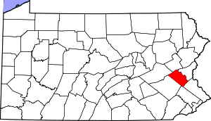 | |
| Boroughs | ||
| Townships |
| |
| CDPs | ||
| Unincorporated communities |
| |
| Footnotes | ‡This populated place also has portions in an adjacent county or counties | |
| Authority control |
|
|---|