Bagert
Bagert is a commune in the department of Ariège in the Occitanie region of south-western France.
Bagert | |
|---|---|
Location of Bagert 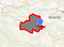
| |
 Bagert  Bagert | |
| Coordinates: 43°04′44″N 1°04′59″E | |
| Country | France |
| Region | Occitanie |
| Department | Ariège |
| Arrondissement | Saint-Girons |
| Canton | Portes du Couserans |
| Intercommunality | Volvestre ariégeois |
| Government | |
| • Mayor (2014–2020) | Jean-Claude Dubois |
| Area 1 | 3.28 km2 (1.27 sq mi) |
| Population (2017-01-01)[1] | 38 |
| • Density | 12/km2 (30/sq mi) |
| Time zone | UTC+01:00 (CET) |
| • Summer (DST) | UTC+02:00 (CEST) |
| INSEE/Postal code | 09033 /09230 |
| Elevation | 340–563 m (1,115–1,847 ft) (avg. 500 m or 1,600 ft) |
| 1 French Land Register data, which excludes lakes, ponds, glaciers > 1 km2 (0.386 sq mi or 247 acres) and river estuaries. | |
The inhabitants of the commune are known as Bagertois or Bagertoises.[2]
Geography
The commune is situated in the former province of Volvestre some 16 km (9.9 mi) north-west of Saint-Girons and 6 km north of Mercenac. Access to the commune is by the D335 road which branches off the D35 east of Betchat and passes through the heart of the commune then continues south-east to join the D3. The commune is predominantly forest with some farmland.[3]
The Ruisseau de Sournet forms the northern border of the commune as it flows west then north to join the Lens. The Ruisseau de Belloc forms part of the south-eastern border of the commune then flows north-west through the south of the commune to eventually join the Lens.[3]
Neighbouring communes and villages[4]
Places adjacent to Bagert | ||||||||||
|---|---|---|---|---|---|---|---|---|---|---|
| ||||||||||
Administration
| From | To | Name | Party | Position |
|---|---|---|---|---|
| 2001 | 2008 | Alain Talarmin | ||
| 2008 | 2014 | André Marsan | ||
| 2014 | 2020 | Jean-Claude Dubois |
(Not all data is known)
Demography
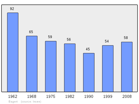
In 2010 the commune had 59 inhabitants. The evolution of the number of inhabitants is known from the population censuses conducted in the commune since 1793. From the 21st century, a census of communes with fewer than 10,000 inhabitants is held every five years, unlike larger communes that have a sample survey every year.[Note 1]
| 1793 | 1800 | 1806 | 1821 | 1831 | 1836 | 1841 | 1846 | 1851 |
|---|---|---|---|---|---|---|---|---|
| 233 | 233 | 295 | 209 | 272 | 297 | 318 | 321 | 311 |
| 1856 | 1861 | 1866 | 1872 | 1876 | 1881 | 1886 | 1891 | 1896 |
|---|---|---|---|---|---|---|---|---|
| 290 | 306 | 284 | 266 | 262 | 251 | 240 | 219 | 210 |
| 1901 | 1906 | 1911 | 1921 | 1926 | 1931 | 1936 | 1946 | 1954 |
|---|---|---|---|---|---|---|---|---|
| 202 | 201 | 177 | 168 | 161 | 151 | 143 | 112 | 95 |
| 1962 | 1968 | 1975 | 1982 | 1990 | 1999 | 2006 | 2010 | - |
|---|---|---|---|---|---|---|---|---|
| 92 | 65 | 59 | 56 | 45 | 54 | - | 59 | - |
See also
External links
- Bagert on Lion1906
- Bagert on Géoportail, National Geographic Institute (IGN) website (in French)
- Bagert on the 1750 Cassini Map
Notes and references
Notes
- At the beginning of the 21st century, the methods of identification have been modified by Law No. 2002-276 of 27 February 2002 Archived 6 March 2016 at the Wayback Machine, the so-called "law of local democracy" and in particular Title V "census operations" allows, after a transitional period running from 2004 to 2008, the annual publication of the legal population of the different French administrative districts. For communes with a population greater than 10,000 inhabitants, a sample survey is conducted annually, the entire territory of these communes is taken into account at the end of the period of five years. The first "legal population" after 1999 under this new law came into force on 1 January 2009 and was based on the census of 2006.
References
- "Populations légales 2017". INSEE. Retrieved 6 January 2020.
- Inhabitants of Ariège (in French)
- Google Maps
- Géoportail, IGN (in French)
- List of Mayors of France (in French)
| Wikimedia Commons has media related to Bagert. |