Aston, Ariège
Aston is a commune in the Ariège department in the Occitanie region of south-western France.
Aston | |
|---|---|
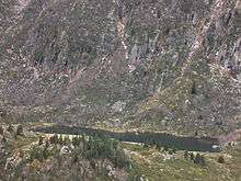
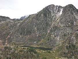 View of the Étang de Larnoum one of many Étangs in the commune | |
Location of Aston 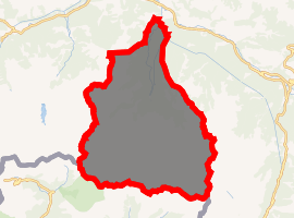
| |
 Aston  Aston | |
| Coordinates: 42°46′32″N 1°40′27″E | |
| Country | France |
| Region | Occitanie |
| Department | Ariège |
| Arrondissement | Foix |
| Canton | Haute-Ariège |
| Intercommunality | CC Haute Ariège |
| Government | |
| • Mayor (2014-2020) | Jean Lassalle |
| Area 1 | 153.8 km2 (59.4 sq mi) |
| Population (2017-01-01)[1] | 220 |
| • Density | 1.4/km2 (3.7/sq mi) |
| Time zone | UTC+01:00 (CET) |
| • Summer (DST) | UTC+02:00 (CEST) |
| INSEE/Postal code | 09024 /09310 |
| Elevation | 554–2,912 m (1,818–9,554 ft) (avg. 560 m or 1,840 ft) |
| 1 French Land Register data, which excludes lakes, ponds, glaciers > 1 km2 (0.386 sq mi or 247 acres) and river estuaries. | |
The inhabitants of the commune are known as Astonnais or Astonnaises.[2]
Geography
Aston is located some 90 km west of Perpignan and 30 km south of Foix. It is located high in the Pyrenees with its southern border the border between France and Andorra. Access to the commune is solely by a local road from Les Cabannes in the north to the village which lies at the northern tip of the commune. The D522 road from Les Cabannes passes down the eastern border of the commune in a tortuous route which terminates at the Angaka ski resort just east of the commune. Except for a very small area around the village the commune is extremely rugged and heavily forested.[3]
The Aston river rises in the south of the commune and flows north, passing through the village, to join the Ariège at Les Cabannes, gathering a very large number of tributaries from all corners of the commune.[3]
Neighbouring communes and villages[4]
Places adjacent to Aston, Ariège | |
|---|---|
Administration
List of Successive Mayors[5]
| From | To | Name | Party | Position |
|---|---|---|---|---|
| 2001 | 2020 | Jean Lasalle |
(Not all data is known)
Demography
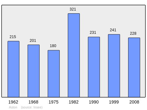
In 2010 the commune had 218 inhabitants. The evolution of the number of inhabitants is known from the population censuses conducted in the commune since 1793. From the 21st century, a census of communes with fewer than 10,000 inhabitants is held every five years, unlike larger towns that have a sample survey every year.[Note 1]
| 1793 | 1800 | 1806 | 1821 | 1831 | 1836 | 1841 | 1846 | 1851 |
|---|---|---|---|---|---|---|---|---|
| - | 266 | 471 | 466 | 529 | 569 | 570 | 586 | 604 |
| 1856 | 1861 | 1866 | 1872 | 1876 | 1881 | 1886 | 1891 | 1896 |
|---|---|---|---|---|---|---|---|---|
| 510 | 503 | 517 | 502 | 464 | 422 | 414 | 371 | 373 |
| 1901 | 1906 | 1911 | 1921 | 1926 | 1931 | 1936 | 1946 | 1954 |
|---|---|---|---|---|---|---|---|---|
| 334 | 315 | 296 | 246 | 211 | 198 | 181 | 318 | 229 |
| 1962 | 1968 | 1975 | 1982 | 1990 | 1999 | 2006 | 2010 | - |
|---|---|---|---|---|---|---|---|---|
| 215 | 201 | 180 | 321 | 231 | 241 | 237 | 218 | - |
Economy
The commune has two dams for the generation of Hydroelectricity: the Laparan and the Riète. They are operated by Électricité de France.
Sites and monuments
- The Étang de Larnoum
See also
External links
- Aston on Géoportail, National Geographic Institute (IGN) website (in French)
- Aston on the 1750 Cassini Map
Notes and references
Notes
- At the beginning of the 21st century, the methods of identification have been modified by Law No. 2002-276 of 27 February 2002 Archived 6 March 2016 at the Wayback Machine, the so-called "law of local democracy" and in particular Title V "census operations" allows, after a transitional period running from 2004 to 2008, the annual publication of the legal population of the different French administrative districts. For communes with a population greater than 10,000 inhabitants, a sample survey is conducted annually, the entire territory of these communes is taken into account at the end of the period of five years. The first "legal population" after 1999 under this new law came into force on 1 January 2009 and was based on the census of 2006.
References
- "Populations légales 2017". INSEE. Retrieved 6 January 2020.
- Inhabitants of Ariège (in French)
- Google Maps
- Géoportail, IGN (in French)
- List of Mayors of France (in French)
| Wikimedia Commons has media related to Aston (Ariège). |