Autheuil-en-Valois
Autheuil-en-Valois is a commune in the Oise department in northern France.
Autheuil-en-Valois | |
|---|---|
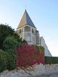 The town hall in Autheuil-en-Valois | |
Location of Autheuil-en-Valois 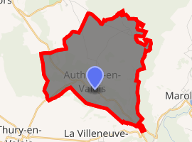
| |
 Autheuil-en-Valois  Autheuil-en-Valois | |
| Coordinates: 49°10′22″N 3°03′41″E | |
| Country | France |
| Region | Hauts-de-France |
| Department | Oise |
| Arrondissement | Senlis |
| Canton | Nanteuil-le-Haudouin |
| Intercommunality | CC Pays Valois |
| Government | |
| • Mayor (2014-2020) | Pierre Caudron |
| Area 1 | 9.24 km2 (3.57 sq mi) |
| Population (2017-01-01)[1] | 272 |
| • Density | 29/km2 (76/sq mi) |
| Time zone | UTC+01:00 (CET) |
| • Summer (DST) | UTC+02:00 (CEST) |
| INSEE/Postal code | 60031 /60890 |
| Elevation | 65–149 m (213–489 ft) (avg. 116 m or 381 ft) |
| 1 French Land Register data, which excludes lakes, ponds, glaciers > 1 km2 (0.386 sq mi or 247 acres) and river estuaries. | |
Population
| Year | Pop. | ±% |
|---|---|---|
| 1793 | 460 | — |
| 1800 | 492 | +7.0% |
| 1806 | 513 | +4.3% |
| 1821 | 467 | −9.0% |
| 1831 | 529 | +13.3% |
| 1836 | 538 | +1.7% |
| 1841 | 547 | +1.7% |
| 1846 | 520 | −4.9% |
| 1851 | 505 | −2.9% |
| 1856 | 483 | −4.4% |
| 1861 | 457 | −5.4% |
| 1866 | 466 | +2.0% |
| 1872 | 454 | −2.6% |
| 1876 | 420 | −7.5% |
| 1881 | 362 | −13.8% |
| 1886 | 365 | +0.8% |
| 1891 | 378 | +3.6% |
| 1896 | 348 | −7.9% |
| 1901 | 324 | −6.9% |
| 1906 | 328 | +1.2% |
| 1911 | 326 | −0.6% |
| 1921 | 300 | −8.0% |
| 1926 | 294 | −2.0% |
| 1931 | 272 | −7.5% |
| 1936 | 272 | +0.0% |
| 1946 | 279 | +2.6% |
| 1954 | 246 | −11.8% |
| 1962 | 235 | −4.5% |
| 1968 | 204 | −13.2% |
| 1975 | 166 | −18.6% |
| 1982 | 162 | −2.4% |
| 1990 | 230 | +42.0% |
| 1999 | 213 | −7.4% |
| 2006 | 246 | +15.5% |
| 2009 | 282 | +14.6% |
| 2015 | 278 | −1.4% |
See also
References
- "Populations légales 2017". INSEE. Retrieved 6 January 2020.
| Wikimedia Commons has media related to Autheuil-en-Valois. |
| Authority control |
|
|---|
This article is issued from Wikipedia. The text is licensed under Creative Commons - Attribution - Sharealike. Additional terms may apply for the media files.