Winnebago, Illinois
Winnebago is a village in Winnebago County, Illinois. It is part of the Rockford-Winnebago Metropolitan Statistical Area. The population was 3,101 at the 2010 census, up from 2,958 in 2000.
Winnebago | |
|---|---|
Village | |
Looking on the main street of Winnebago | |
| Nickname(s): Indians | |
| Motto(s): Welcome to Wonderful Winnebago | |
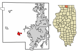
 Location of Winnebago in Winnebago County, Illinois. | |
.svg.png) Location of Illinois in the United States | |
| Coordinates: 42°15′56″N 89°14′26″W | |
| Country | United States |
| State | Illinois |
| County | Winnebago |
| Township | Winnebago |
| Government | |
| • Village President | Frank Eubank |
| Area | |
| • Total | 1.93 sq mi (5.01 km2) |
| • Land | 1.93 sq mi (5.01 km2) |
| • Water | 0.00 sq mi (0.00 km2) |
| Elevation | 869 ft (265 m) |
| Population (2010) | |
| • Total | 3,101 |
| • Estimate (2019)[3] | 2,991 |
| • Density | 1,546.54/sq mi (597.27/km2) |
| Time zone | UTC-6 (CST) |
| • Summer (DST) | UTC-5 (CDT) |
| ZIP Code(s) | 61088 |
| Area code(s) | 815 |
| FIPS code | 17-82491 |
| Wikimedia Commons | Winnebago, Illinois |
| Website | http://www.villageofwinnebago.com/ |
History
James Weber Linn (1876–1939), educator and politician, was born in Winnebago.[4]
Geography
Winnebago is located at 42°15′56″N 89°14′26″W (42.265652, -89.240548).[5] According to the 2010 census, Winnebago has a total area of 1.95 square miles (5.05 km2), all land.[6]
Demographics
| Historical population | |||
|---|---|---|---|
| Census | Pop. | %± | |
| 1880 | 504 | — | |
| 1890 | 464 | −7.9% | |
| 1900 | 405 | −12.7% | |
| 1910 | 415 | 2.5% | |
| 1920 | 495 | 19.3% | |
| 1930 | 588 | 18.8% | |
| 1940 | 637 | 8.3% | |
| 1950 | 752 | 18.1% | |
| 1960 | 1,059 | 40.8% | |
| 1970 | 1,285 | 21.3% | |
| 1980 | 1,644 | 27.9% | |
| 1990 | 1,840 | 11.9% | |
| 2000 | 2,958 | 60.8% | |
| 2010 | 3,101 | 4.8% | |
| Est. 2019 | 2,991 | [3] | −3.5% |
| U.S. Decennial Census[7] | |||
As of the census[8] of 2000, there were 3,000 people, 1,009 households, and 841 families residing in the village. The population density was 1,500 people per square mile (821.6/km2). There were 1,023 housing units at an average density of 735.0 per square mile (284.2/km2). The racial makeup of the village was 98.14% White, 1.12% African American, 0.03% Native American, 0.30% Asian, and 0.41% from two or more races. Hispanic or Latino of any race were 1.18% of the population.
There were 1,009 households out of which 50.3% had children under the age of 18 living with them, 69.9% were married couples living together, 10.7% had a female householder with no husband present, and 16.6% were non-families. 14.1% of all households were made up of individuals and 7.2% had someone living alone who was 65 years of age or older. The average household size was 2.93 and the average family size was 3.24.
In the village, the population was spread out with 34.3% under the age of 18, 5.7% from 18 to 24, 32.6% from 25 to 44, 19.1% from 45 to 64, and 8.3% who were 65 years of age or older. The median age was 34 years. For every 100 females, there were 94.1 males. For every 100 females age 18 and over, there were 90.8 males.
The median income for a household in the village was $59,891, and the median income for a family was $62,685. Males had a median income of $44,851 versus $25,817 for females. The per capita income for the village was $21,019. About 0.9% of families and 1.1% of the population were below the poverty line, including 1.0% of those under age 18 and 3.9% of those age 65 or over.
Education
Students in Winnebago are served by Winnebago CUSD#323. The district has one high school, one middle school and two elementary schools.[9] The Winnebago schools website is http://www.winnebagoschools.org/.
References
- "2019 U.S. Gazetteer Files". United States Census Bureau. Retrieved July 14, 2020.
- "USGS detail on Newtown". Retrieved 2007-10-21.
- "Population and Housing Unit Estimates". United States Census Bureau. May 24, 2020. Retrieved May 27, 2020.
- 'Illinois Blue Book 1939-1940,' Biographical Sketch of James Weber Linn, pg. 154-155
- "US Gazetteer files: 2010, 2000, and 1990". United States Census Bureau. 2011-02-12. Retrieved 2011-04-23.
- "G001 - Geographic Identifiers - 2010 Census Summary File 1". United States Census Bureau. Archived from the original on 2020-02-13. Retrieved 2015-12-25.
- "Census of Population and Housing". Census.gov. Retrieved June 4, 2015.
- "U.S. Census website". United States Census Bureau. Retrieved 2008-01-31.
- ">School district web page, retrieved 2009-01-09
