Wan Singpyin
Wan Singpyin (also Wān Singpyin[1]) is a town in Kengtong District of Shan State of Myanmar. The town is located alongside the Nam Loi (Loi River), a tributary of the Mekong.[2] The nearest airport is 50 kilometres (31 mi) away in Kengtung.
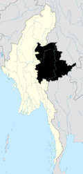
Wan Singpyin | |
|---|---|
 Wan Singpyin Location in Burma | |
| Coordinates: 21°44′21″N 99°27′36″E | |
| Country | |
| Division | Shan State |
| Districts | Kengtong |
| Township | Mong Khet |
| Population | |
| • Religions | Buddhism |
| Time zone | UTC+6.30 (MST) |
| WOEID | 1017965 |
Notes
- "Wān Singpyin (Approved)" Wan Singpyin at GEOnet Names Server, United States National Geospatial-Intelligence Agency
- NF 47-11 "Keng Tung, Burma" U.S. Army Map Service topographic map 1:250,000, Series U-542, first printing December 1959
gollark: (well, it has some labels, just not that many)
gollark: The labels, I mean.
gollark: My test setup works without those, even.
gollark: According to the docs I read there was... less than that.
gollark: Wait, you need to add *all* of those to *every proxied service*?
External links
- "Wan Singpyin Map — Satellite Images of Wan Singpyin" Maplandia World Gazetteer
Capital: Mong Khet | |
|

This article is issued from Wikipedia. The text is licensed under Creative Commons - Attribution - Sharealike. Additional terms may apply for the media files.