Kunlong
Kunlong is the capital town of Kunlong Township in Shan State. its coordination is 23 25' 00" N and 98 39' 00" E.[1]
Kunlong ကွမ်းလုံမြို့ | |
|---|---|
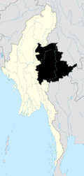
 Kunlong Location in Burma | |
| Coordinates: 23°25′00″N 98°39′00″E | |
| Country | |
| Division | |
| Population (2005) | |
| • Ethnicities | Shan, Wa |
| • Religions | Buddhism |
| Time zone | UTC+6.30 (MST) |
The Wa people inhabit the hills immediately overlooking the Nam Ting valley.
History
It is the home of Kunlong Bridge over the Salween River. There was a 42 days-long battle between Burma Communist Party (BCP) and Myanmar Army from November 1971 to January 1972 to control that strategic bridge.[2]
Further reading
gollark: ↑ yellow thing
gollark: https://tenor.com/view/yellow-alert-gif-7762498
gollark: Lots of things are yellow, however.
gollark: People have been wrong about things before, and this is definitely one of those times because there has been in no way any collusion with any firm offering edible carbohydrate products.
gollark: It's not pizza. There were no deals, under-the-table or otherwise, with pizza companies. No pizza companies pay for any kind of subliminal advertising involving me.
References

This article is issued from Wikipedia. The text is licensed under Creative Commons - Attribution - Sharealike. Additional terms may apply for the media files.