Kunlong District
Kunlong District is a district of the Shan State in Myanmar. It consists of 2 towns and 458 villages. The main road of the District, Hsenwi-Kunlong-Chinshwehaw road, is 66 miles (106 kilometres) long.[2]
Kunlong | |
|---|---|
District | |
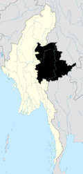
 Kunlong Location in Burma | |
| Coordinates: 23°25′20″N 98°39′10″E | |
| Country | |
| State | Shan State |
| Elevation | 489 m (1,604 ft) |
| Time zone | UTC+6.30 (MST) |
Townships
The district contained the following townships:
Hopang Township became part of Hopang District and is now not anymore under Kunlong District since September 2011.[3] Now Kunlong District just consists of Kunlong Township
gollark: The Wikipedia article explains how you can attain things from that.
gollark: Xylophone Yttrium Zoo, India.
gollark: Either by starting at the *maximum* length for everything and seeing where it can be shifted to be smaller, or starting at a more optimistic one and trying to make it actually work
gollark: They have to run a bunch of optimization passes over it.
gollark: This is actually a thing I read about on the fasm forum or something.
References
- GoogleEarth
- MRTV Page 16 Column 2
- MRTV Page 10 Column 3
Capital: | |
|

This article is issued from Wikipedia. The text is licensed under Creative Commons - Attribution - Sharealike. Additional terms may apply for the media files.