Village of Four Seasons, Missouri
Village of Four Seasons is a village in Camden County, Missouri, United States. The population was 2,217 at the 2010 census. The village is situated on the shores of Lake of the Ozarks and is a popular tourist destination along with the other communities in the area.
Village of Four Seasons, Missouri | |
|---|---|
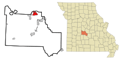 Location of Village of Four Seasons, Missouri | |
| Coordinates: 38°12′4″N 92°42′56″W | |
| Country | United States |
| State | Missouri |
| County | Camden |
| Area | |
| • Total | 4.71 sq mi (12.20 km2) |
| • Land | 4.65 sq mi (12.03 km2) |
| • Water | 0.07 sq mi (0.17 km2) |
| Elevation | 738 ft (225 m) |
| Population | |
| • Total | 2,217 |
| • Estimate (2019)[3] | 2,294 |
| • Density | 493.76/sq mi (190.65/km2) |
| Time zone | UTC-6 (Central (CST)) |
| • Summer (DST) | UTC-5 (CDT) |
| ZIP code | 65049 |
| Area code(s) | 573 |
| FIPS code | 29-76157[4] |
| GNIS feature ID | 1669605[5] |
| Website | https://villageoffourseasons.com/ |
Geography
Village of Four Seasons is located at 38°12′4″N 92°42′56″W (38.201086, -92.715556).[6]
According to the United States Census Bureau, the village has a total area of 4.59 square miles (11.89 km2), of which 4.52 square miles (11.71 km2) is land and 0.07 square miles (0.18 km2) is water.[7]
Demographics
| Historical population | |||
|---|---|---|---|
| Census | Pop. | %± | |
| 1990 | 805 | — | |
| 2000 | 1,493 | 85.5% | |
| 2010 | 2,217 | 48.5% | |
| Est. 2019 | 2,294 | [3] | 3.5% |
| U.S. Decennial Census[8] | |||
2010 census
At the 2010 census,[2] there were 2,217 people, 966 households and 701 families residing in the village. The population density was 490.5 inhabitants per square mile (189.4/km2). There were 2,606 housing units at an average density of 576.5 per square mile (222.6/km2). The racial makeup of the village was 97.6% White, 0.9% African American, 0.5% Native American, 0.4% Asian, 0.2% from other races, and 0.5% from two or more races. Hispanic or Latino of any race were 1.1% of the population.
There were 966 households of which 26.4% had children under the age of 18 living with them, 63.7% were married couples living together, 5.4% had a female householder with no husband present, 3.5% had a male householder with no wife present, and 27.4% were non-families. 21.9% of all households were made up of individuals and 7.6% had someone living alone who was 65 years of age or older. The average household size was 2.30 and the average family size was 2.65.
The median age was 47.3 years. 20.2% of residents were under the age of 18; 4.1% were between the ages of 18 and 24; 23.1% were from 25 to 44; 32.4% were from 45 to 64; and 20.3% were 65 years of age or older. The gender makeup of the village was 48.8% male and 51.2% female.
2000 census
At the 2000 census,[4] there were 1,493 people, 641 households and 496 families residing in the village. The population density was 334.2 per square mile (129.0/km2). There were 2,025 housing units at an average density of 453.3 per square mile (174.9/km2). The racial makeup was 98.19% White, 0.13% African American, 0.07% Native American, 0.33% Asian, 0.20% from other races, and 1.07% from two or more races. Hispanic or Latino of any race were 0.94% of the population.
There were 641 households of which 23.2% had children under the age of 18 living with them, 68.0% were married couples living together, 7.0% had a female householder with no husband present, and 22.6% were non-families. 18.3% of all households were made up of individuals and 5.1% had someone living alone who was 65 years of age or older. The average household size was 2.33 and the average family size was 2.62.
19.6% of the population were under the age of 18, 6.3% from 18 to 24, 20.9% from 25 to 44, 36.0% from 45 to 64, and 17.3% who were 65 years of age or older. The median age was 47 years. For every 100 females, there were 91.4 males. For every 100 females age 18 and over, there were 96.2 males.
The median household income was $59,063 and the median family incomewas $60,714. Males had a median income of $42,250 and females $25,417. The per capita income was $36,593. About 8.7% of families and 10.7% of the population were below the poverty line, including 28.1% of those under age 18 and 1.6% of those age 65 or over.
References
- "2019 U.S. Gazetteer Files". United States Census Bureau. Retrieved July 26, 2020.
- "U.S. Census website". United States Census Bureau. Retrieved July 8, 2012.
- "Population and Housing Unit Estimates". United States Census Bureau. May 24, 2020. Retrieved May 27, 2020.
- "U.S. Census website". United States Census Bureau. Retrieved January 31, 2008.
- "US Board on Geographic Names". United States Geological Survey. October 25, 2007. Retrieved January 31, 2008.
- "US Gazetteer files: 2010, 2000, and 1990". United States Census Bureau. February 12, 2011. Retrieved April 23, 2011.
- "US Gazetteer files 2010". United States Census Bureau. Archived from the original on January 12, 2012. Retrieved July 8, 2012.
- "Census of Population and Housing". Census.gov. Retrieved June 4, 2015.
Municipalities and communities of Camden County, Missouri, United States | ||
|---|---|---|
| Cities | 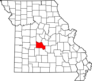 Map of Missouri highlighting Camden County | |
| Villages | ||
| Townships | ||
| CDPs | ||
| Other unincorporated communities | ||
| Footnotes | ‡This populated place also has portions in an adjacent county or counties | |