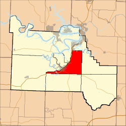
Kiheka Township, Camden County, Missouri
Kiheka Township is one of eleven townships in Camden County, Missouri, USA. As of the 2000 census, its population was 4,237.
Kiheka Township | |
|---|---|
 | |
| Coordinates: 38°01′47″N 092°41′03″W | |
| Country | United States |
| State | Missouri |
| County | Camden |
| Area | |
| • Total | 42.12 sq mi (109.08 km2) |
| • Land | 41.61 sq mi (107.76 km2) |
| • Water | 0.51 sq mi (1.32 km2) 1.21% |
| Elevation | 728 ft (222 m) |
| Population (2000) | |
| • Total | 4,237 |
| • Density | 101.8/sq mi (39.3/km2) |
| FIPS code | 29-38585[2] |
| GNIS feature ID | 1729741 |
Geography
Kiheka Township covers an area of 42.12 square miles (109.1 km2) and contains no incorporated settlements. It contains six cemeteries: Caviness, Davis, Hugo, Percival Memorial, Williams and Zion.
The stream of Watered Hollow Branch runs through this township.
Transportation
Kiheka Township contains one airport or landing strip, Heritage Landing Strip.
gollark: This will make 1 equal 3 in python, and also probably crash the interpreter.
gollark: ```pythonimport sysimport ctypesctypes.memmove(id(1), id(3), sys.getsizeof(1))```
gollark: In that case, I will redefine the concept of 1.
gollark: They are all named Alan. Done.
gollark: The Oxford English Dictionary?
References
- "US Board on Geographic Names". United States Geological Survey. 2007-10-25. Retrieved 2008-01-31.
- "U.S. Census website". United States Census Bureau. Retrieved 2008-01-31.
External links
Municipalities and communities of Camden County, Missouri, United States | ||
|---|---|---|
| Cities | 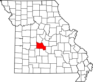 Map of Missouri highlighting Camden County | |
| Villages | ||
| Townships | ||
| CDPs | ||
| Other unincorporated communities | ||
| Footnotes | ‡This populated place also has portions in an adjacent county or counties | |
This article is issued from Wikipedia. The text is licensed under Creative Commons - Attribution - Sharealike. Additional terms may apply for the media files.