Pawhuska Township, Camden County, Missouri
Pawhuska Township is one of eleven townships in Camden County, Missouri, USA. As of the 2000 census, its population was 5,617.[1]
Pawhuska Township | |
|---|---|
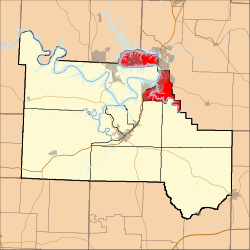 Location in Camden County | |
| Coordinates: 38°11′05″N 92°42′58″W | |
| Country | |
| State | |
| County | Camden |
| Area | |
| • Total | 30.18 sq mi (78.17 km2) |
| • Land | 19.48 sq mi (50.46 km2) |
| • Water | 10.7 sq mi (27.72 km2) 35.46% |
| Elevation | 732 ft (223 m) |
| Population (2000) | |
| • Total | 5,617 |
| • Density | 288.3/sq mi (111.3/km2) |
| Time zone | UTC-6 (CST) |
| • Summer (DST) | UTC-5 (CDT) |
| ZIP codes | 65047, 65049, 65052, 65065, 65079 |
| GNIS feature ID | 2397852 |
Geography
According to the United States Census Bureau, Pawhuska Township covers an area of 30.18 square miles (78.17 square kilometers); of this, 19.48 square miles (50.46 square kilometers, 64.55 percent) is land and 10.7 square miles (27.72 square kilometers, 35.46 percent) is water.
Cities, towns, villages
- Lake Ozark (partial)
- Osage Beach (partial)
- Village of Four Seasons
Unincorporated towns
- Four Seasons at 38.198087°N 92.711021°W
- Laguna Beach at 38.130311°N 92.651574°W
(This list is based on USGS data and may include former settlements.)
Adjacent townships
- Glaze Township, Miller County (east)
- Jackson Township (southeast)
- Kiheka Township (south)
- Osage Township (southwest)
- Jasper Township (west)
- Osage Township, Morgan County (northwest)
Cemeteries
The township contains these six cemeteries: Arnold, Conway, Downing, Houston, Riverview and Stevens.
Major highways
Airports and landing strips
- Eagles Roost Heliport
- Links Landing Seaplane Base
- Linn Creek-Grand Glaize Memorial Airport
Landmarks
- Lake of the Ozarks State Park (west edge)
School districts
- Camdenton R-III School District
- School Of The Osage R-II
Political districts
- Missouri's 4th congressional district
- Missouri's 4th congressional district
- State House District 115
- State House District 155
- State Senate District 33
- State Senate District 6
gollark: I mostly learn things by writing simple things in them using example code, manuals and in Nim's case the big table of stdlib functions.
gollark: I was going to say something from there, but the client on my phone isn't showing this room.
gollark: I basically don't use Matrix at all because there aren't any interesting communities there (which I'm aware of) and joining things is sloooow.
gollark: But I have Discord open more so I'm not using that.
gollark: I managed to get my dendrite instance to join the matrix room after several minutes of waiting.
References
- United States Census Bureau 2008 TIGER/Line Shapefiles
- United States Board on Geographic Names (GNIS)
- United States National Atlas
- "U.S. Census website". Retrieved 2009-05-17.
External links
Places adjacent to Pawhuska Township, Camden County, Missouri | |
|---|---|
Municipalities and communities of Camden County, Missouri, United States | ||
|---|---|---|
| Cities | 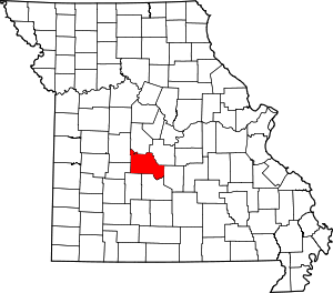 Map of Missouri highlighting Camden County | |
| Villages | ||
| Townships | ||
| CDPs | ||
| Other unincorporated communities | ||
| Footnotes | ‡This populated place also has portions in an adjacent county or counties | |
This article is issued from Wikipedia. The text is licensed under Creative Commons - Attribution - Sharealike. Additional terms may apply for the media files.