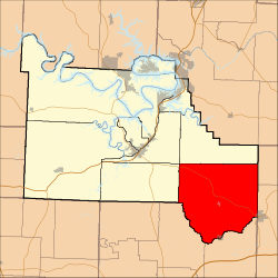
Auglaize Township, Camden County, Missouri
Auglaize Township is one of eleven townships in Camden County, Missouri, USA. As of the 2000 census, its population was 2,227.
Auglaize Township | |
|---|---|
 | |
| Coordinates: 37°56′09″N 092°33′21″W | |
| Country | United States |
| State | Missouri |
| County | Camden |
| Area | |
| • Total | 122.69 sq mi (317.76 km2) |
| • Land | 122.57 sq mi (317.47 km2) |
| • Water | 0.11 sq mi (0.29 km2) 0.09% |
| Elevation | 958 ft (292 m) |
| Population (2000) | |
| • Total | 2,227 |
| • Density | 18.2/sq mi (7/km2) |
| FIPS code | 29-02476[2] |
| GNIS feature ID | 0766389 |
Auglaize Township was established in 1841.[3]
Geography
Auglaize Township covers an area of 122.69 square miles (317.8 km2) and contains one incorporated settlement, Stoutland. It contains ten cemeteries: Brown, Campground, Chalfant, Dodson, Hammer, Hillhouse, Knight, Lewis, Sharp and Traw.
The streams of Conns Creek, Mill Creek, Murphy Creek, Sellars Creek, Shakerag Creek, Stoops Branch, Stoutland Creek and Stoutland Creek run through this township.
gollark: Don't they mostly have onboard power metering anyway?
gollark: Oh, the US runs on 120V, right.
gollark: I see.
gollark: Theoretically I can measure the power draw of a lot of bits of my laptop, but this is not very useful unless trying to optimize battery life or something.
gollark: What do you actually need that for?
References
- "US Board on Geographic Names". United States Geological Survey. 2007-10-25. Retrieved 2008-01-31.
- "U.S. Census website". United States Census Bureau. Retrieved 2008-01-31.
- "Camden County Place Names, 1928–1945 (archived)". The State Historical Society of Missouri. Archived from the original on 24 June 2016. Retrieved 8 September 2016.CS1 maint: BOT: original-url status unknown (link)
External links
Municipalities and communities of Camden County, Missouri, United States | ||
|---|---|---|
| Cities | 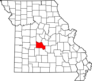 Map of Missouri highlighting Camden County | |
| Villages | ||
| Townships | ||
| CDPs | ||
| Other unincorporated communities | ||
| Footnotes | ‡This populated place also has portions in an adjacent county or counties | |
This article is issued from Wikipedia. The text is licensed under Creative Commons - Attribution - Sharealike. Additional terms may apply for the media files.