United States physiographic region
The physiographic regions of the contiguous United States comprise 8 regions, 25 provinces, and 85 sections.[1] The system dates to Nevin Fenneman's paper Physiographic Subdivision of the United States, published in 1917.[2] Fenneman expanded and presented his system more fully in two books, Physiography of western United States (1931),[3] and Physiography of eastern United States (1938).[4] In these works Fenneman described 25 provinces and 85 sections of the United States physiography.[5]

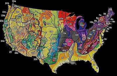
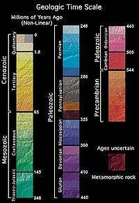
USGS map colored by paleogeological areas and demarcating the sections of the U.S physiographic regions: Laurentian Upland (area 1), Atlantic Plain (2-3), Appalachian Highlands (4-10), Interior Plains (11-13), Interior Highlands (14-15), Rocky Mountain System (16-19), Intermontane Plateaus (20-22), & Pacific Mountain System (23-25)

The legend of paleogeological color also depicts topographic terrain.
Physiographic divisions
| Region | Province | Section |
|---|---|---|
| I. Laurentian Upland | 1. Superior Upland | |
| II. Atlantic Plain | 2. Continental Shelf (not on map) | |
| 3. Coastal Plain | 3a. Embayed section | |
| 3b. Sea Island section | ||
| 3c. Floridian section | ||
| 3d. East Gulf Coastal Plain | ||
| 3e. Mississippi Alluvial Plain | ||
| 3f. West Gulf Coastal Plain | ||
| III. Appalachian Highlands | 4. Piedmont | 4a. Piedmont Upland |
| 4b. Piedmont Lowlands | ||
| 5. Blue Ridge province | 5a. Northern section | |
| 5b. Southern section | ||
| 6. Valley and Ridge province | 6a. Tennessee section | |
| 6b. Middle section | ||
| 6c. Hudson Valley | ||
| 7. St. Lawrence Valley | 7a. Champlain section | |
| 7b. Northern section (not on map) | ||
| 8. Appalachian Plateaus province | 8a. Mohawk section | |
| 8b. Catskill section | ||
| 8c. Southern New York section | ||
| 8d. Allegheny Plateau section | ||
| 8e. Kanawha section | ||
| 8f. Cumberland Plateau section | ||
| 8g. Cumberland Mountain section | ||
| 9. New England Province | 9a. Seaboard Lowland section | |
| 9b. New England Upland section | ||
| 9c. White Mountain section | ||
| 9d. Green Mountain section | ||
| 9e. Taconic section | ||
| 10. Adirondack province | ||
| IV. Interior Plains | 11. Interior Low Plateaus | 11a. Highland Rim |
| 11b. Lexington Plain | ||
| 11c. Nashville Basin | ||
| 12. Central Lowland | 12a. Eastern Lake | |
| 12b. Western Lake | ||
| 12c. Wisconsin Driftless | ||
| 12d. Till Plains | ||
| 12e. Dissected Till Plains | ||
| 12f. Osage Plains | ||
| 13. Great Plains | 13a. Missouri Plateau (glaciated) | |
| 13b. Missouri Plateau (unglaciated) | ||
| 13c. Black Hills | ||
| 13d. High Plains | ||
| 13e. Plains Border | ||
| 13f. Colorado Piedmont | ||
| 13g. Raton | ||
| 13h. Pecos Valley | ||
| 13i. Edwards Plateau | ||
| 13j. Central Texas | ||
| V. Interior Highlands | 14. Ozark Plateaus | 14a. Springfield-Salem plateaus |
| 14b. Boston Mountains | ||
| 15. Ouachita province | 15a. Arkansas Valley | |
| 15b. Ouachita Mountains | ||
| VI. Rocky Mountain System | 16. Southern Rocky Mountains | |
| 17. Wyoming Basin | ||
| 18. Middle Rocky Mountains | ||
| 19. Northern Rocky Mountains | ||
| VII. Intermontane Plateaus | 20. Columbia Plateau | 20a. Walla Walla Plateau |
| 20b. Blue Mountain section | ||
| 20c. Payette section | ||
| 20d. Snake River Plain | ||
| 20e. Harney section | ||
| 21. Colorado Plateaus | 21a. High Plateaus of Utah | |
| 21b. Uinta Basin | ||
| 21c. Canyon Lands | ||
| 21d. Navajo section | ||
| 21e. Grand Canyon section | ||
| 21f. Datil section | ||
| 22. Basin and Range Province | 22a. Great Basin section | |
| 22b. Sonoran Desert | ||
| 22c. Salton Trough | ||
| 22d. Mexican Highland | ||
| 22e. Sacramento section | ||
| VIII. Pacific Mountains | 23. Cascade-Sierra Mountains | 23a. Northern Cascade Mountains |
| 23b. Middle Cascade Mountains | ||
| 23c. Southern Cascade Mountains | ||
| 23d. Sierra Nevada | ||
| 24. Pacific Border province | 24a. Puget Trough | |
| 24b. Olympic Mountains | ||
| 24c. Oregon Coast Range | ||
| 24d. Klamath Mountains | ||
| 24e. California Trough | ||
| 24f. California Coast Ranges | ||
| 24g. "Los Angeles Ranges—(Transverse Ranges)" | ||
| 25. Lower California province—(Peninsular Ranges) | ||
gollark: I would be surprised if CC couldn't operate nanomachines via a relay.
gollark: I have Skynet for this. Also SPUDNET.
gollark: Yes, I know. It's just a nonsensical idea.
gollark: PotatOS could be transmitted via LabelNet in just 4 minutes.
gollark: What?
References
- "Physiographic Regions". United States Geological Survey. 2003-04-17. Archived from the original on 2006-05-15. Retrieved 2008-01-30.
- Fenneman, Nevin M. (January 1917). "Physiographic Subdivision of the United States". Proceedings of the National Academy of Sciences of the United States of America. 3 (1): 17–22. doi:10.1073/pnas.3.1.17. OCLC 43473694. PMC 1091163. PMID 16586678.
- Fenneman, Nevin Melancthon (1931). Physiography of western United States. McGraw-Hill. OCLC 487636.
- Fenneman, Nevin Melancthon (1938). Physiography of eastern United States. McGraw-Hill. OCLC 487628.
- "Automated IFSAR Terrain Analysis System". Defense Advanced Research Projects Agency (DOD), Information Sciences Office. 31 August 2001. Retrieved 5 October 2010.
This article is issued from Wikipedia. The text is licensed under Creative Commons - Attribution - Sharealike. Additional terms may apply for the media files.