Pacific Border province
The Pacific Border province is a physiographic province of the Physiographic regions of the world physical geography system. [1]
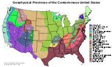
Map of the physiographic provinces of the lower 48 United States, showing the Paciifc Border province (number 18).
Description
The Pacific Border province encompasses most of the North American Pacific Coast, with the southern end at the start of the Lower California-Peninsular Ranges Province in Southern California. The Pacific Border province is in the larger Pacific Mountain System Division—Region.[1] The region is prone to earthquakes, residing along the eastern edge of the Pacific Ring of Fire.
Sections
The Pacific Border province contains seven separate and smaller sections:[1]
- Puget Trough
- Olympic Mountains
- Oregon Coast Range
- Klamath Mountains
- California Trough
- California Coast Ranges
- Transverse Ranges (Los Angeles Ranges)
gollark: Probably because of varying support more than actual hardware differences.
gollark: There's no Nvidia magic here. It's just that stuff is programmed to use CUDA instead of some other language/platform.
gollark: No, it's a GPU computing platform.
gollark: RTX is totally useless to me, as I play games on Linux and do not play massively graphically advanced stuff.
gollark: It's just that stuff supports CUDA more for some reason?
See also
- Cascade-Sierra province
- Pacific Coast Ranges
References
- "Physiographic divisions of the conterminous U. S." United States Geological Survey. Retrieved 25 December 2018.
| Branches |
| ||||||
|---|---|---|---|---|---|---|---|
| Techniques and tools | |||||||
| Institutions |
| ||||||
| Education |
| ||||||
| |||||||
 | ||
| ||
This article is issued from Wikipedia. The text is licensed under Creative Commons - Attribution - Sharealike. Additional terms may apply for the media files.