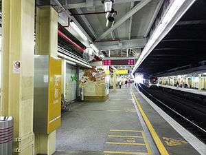
Tai Wo station
Tai Wo (Chinese: 太和; Cantonese Yale: Taaiwò; pronounced: [tʰāːiwɔ̏ː]) is a MTR station in the western part of Tai Po New Town, in New Territories, Hong Kong. The station is located on the East Rail Line, between Fanling and Tai Po Market stations.
| MTR rapid transit station | ||||||||||||||||||||||||||||||||||||||||||||||||||||||||||||||||||||||||||||||||||||||||||||||||||
 Platform 2 | ||||||||||||||||||||||||||||||||||||||||||||||||||||||||||||||||||||||||||||||||||||||||||||||||||
| Chinese name | ||||||||||||||||||||||||||||||||||||||||||||||||||||||||||||||||||||||||||||||||||||||||||||||||||
| Chinese | 太和 | |||||||||||||||||||||||||||||||||||||||||||||||||||||||||||||||||||||||||||||||||||||||||||||||||
| Jyutping | taai3wo4 | |||||||||||||||||||||||||||||||||||||||||||||||||||||||||||||||||||||||||||||||||||||||||||||||||
| Hanyu Pinyin | Tàihé | |||||||||||||||||||||||||||||||||||||||||||||||||||||||||||||||||||||||||||||||||||||||||||||||||
| ||||||||||||||||||||||||||||||||||||||||||||||||||||||||||||||||||||||||||||||||||||||||||||||||||
| General information | ||||||||||||||||||||||||||||||||||||||||||||||||||||||||||||||||||||||||||||||||||||||||||||||||||
| Location | Po Nga Road, Tai Wo Tai Po District, Hong Kong | |||||||||||||||||||||||||||||||||||||||||||||||||||||||||||||||||||||||||||||||||||||||||||||||||
| Coordinates | 22°27′04″N 114°09′40″E | |||||||||||||||||||||||||||||||||||||||||||||||||||||||||||||||||||||||||||||||||||||||||||||||||
| Owned by | Kowloon–Canton Railway Corporation | |||||||||||||||||||||||||||||||||||||||||||||||||||||||||||||||||||||||||||||||||||||||||||||||||
| Operated by | MTR Corporation | |||||||||||||||||||||||||||||||||||||||||||||||||||||||||||||||||||||||||||||||||||||||||||||||||
| Line(s) | ||||||||||||||||||||||||||||||||||||||||||||||||||||||||||||||||||||||||||||||||||||||||||||||||||
| Platforms | 2 (2 side platforms) | |||||||||||||||||||||||||||||||||||||||||||||||||||||||||||||||||||||||||||||||||||||||||||||||||
| Connections | Bus, public light bus | |||||||||||||||||||||||||||||||||||||||||||||||||||||||||||||||||||||||||||||||||||||||||||||||||
| Construction | ||||||||||||||||||||||||||||||||||||||||||||||||||||||||||||||||||||||||||||||||||||||||||||||||||
| Structure type | At-grade (on embankment) | |||||||||||||||||||||||||||||||||||||||||||||||||||||||||||||||||||||||||||||||||||||||||||||||||
| Disabled access | Yes | |||||||||||||||||||||||||||||||||||||||||||||||||||||||||||||||||||||||||||||||||||||||||||||||||
| History | ||||||||||||||||||||||||||||||||||||||||||||||||||||||||||||||||||||||||||||||||||||||||||||||||||
| Opened | 9 May 1989 | |||||||||||||||||||||||||||||||||||||||||||||||||||||||||||||||||||||||||||||||||||||||||||||||||
| Services | ||||||||||||||||||||||||||||||||||||||||||||||||||||||||||||||||||||||||||||||||||||||||||||||||||
| ||||||||||||||||||||||||||||||||||||||||||||||||||||||||||||||||||||||||||||||||||||||||||||||||||
| ||||||||||||||||||||||||||||||||||||||||||||||||||||||||||||||||||||||||||||||||||||||||||||||||||
| Location | ||||||||||||||||||||||||||||||||||||||||||||||||||||||||||||||||||||||||||||||||||||||||||||||||||
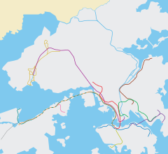
 Tai Wo Location within the MTR system | ||||||||||||||||||||||||||||||||||||||||||||||||||||||||||||||||||||||||||||||||||||||||||||||||||
History
Construction of the station, situated within the eponymous Tai Wo Estate, began in August 1986.[1] It opened on 9 May 1989 as an intermediate station of the East Rail Line, then known as the Kowloon–Canton Railway, upon the completion of the estate.[2]
Station layout
The Tai Wo Station premises are sandwiched between the two wings of Tai Wo Plaza, the shopping mall of Tai Wo Estate. Both of the exits at the station connect to Tai Wo Plaza, and passengers must pass through the mall in order to enter or exit the station.
| L4 Footbridge |
Footbridge | Exit B, Tickets/Fare Adjustment, passageway between platforms 1 and 2 |
| L2 Concourse/ Platforms | ||
| Concourse | Exit A, Tickets/Fare Adjustment, washrooms, automatic teller machines | |
| Side platform, doors will open on the left | ||
| Platform 1 | East Rail line towards Lo Wu or Lok Ma Chau (Fanling) → | |
| Platform 2 | ← East Rail line towards Hung Hom (Tai Po Market) | |
| Side platform, doors will open on the left | ||
Entrances/exits
Connections
Below Tai Wo Station is a transport interchange, where bus and minibus routes connecting the neighbouring rural areas of Lam Tsuen, Tai Hang and Kau Lung Hang are available. This render Tai Wo the gateway to the western rural part of Tai Po District.
- 64K - Yuen Long (West) ↔ Tai Po Market Station
- 64P, 65K - Kadoorie Farm → Tai Po Central (Morning Peak hours, 64P Evening Peak Hours, Reverse Direction)
- 71K - Tai Wo Station ↔ Tai Po Market Station
- 72 - Tai Wo Station ↔ Cheung Sha Wan
- 73 - Wah Ming ↔ Tai Po Industrial Estate/Tai Po Central
- 73A - Wah Ming ↔ Yu Chui Court
- 74A - Tai Wo Station ↔ Kai Yip
- 74C - Kau Lung Hang → Kwun Tong Ferry (Morning Peak hours)
- 74D - Kau Lung Hang ↔ Kwun Tong Ferry (Via Hong Kong Science Park)
- 271P - Kau Lung Hang → Tsim Sha Tsui (Morning Peak hours)
- 273C - Kau Lung Hang → Tsuen Wan West Station (Morning Peak hours)
- 273P - Tai Wo Station → Tsuen Wan West Station (Morning Peak hours)
- 307P - Tai Po ↔ Tin Hau Station (Peak hours)
- 907B - Kwong Fuk Playground → Wan Chai (Morning Peak hours)
- 907C - Tai Po Tau ↔ Wan Chai/Admiralty (Peak hours)
- N73 - Lok Ma Chau ↔ Sha Tin Central (Night route)
- Public light bus routes[4]
- 21K - Wai Tau ↺ Tai Po Market
- 25A - Tai Po Market ↺ Nam Wa Po
- 25B - Tai Po Market ↺ Kau Lung Hang / Yuen Leng
- 25K - Tai Po Market ↔ Ng Tung Chai
References
- "Tai Wo station opens tomorrow". South China Morning Post. 8 May 1989. p. 4.
- "New station". South China Morning Post. 9 May 1989. p. 7.
- "Tai Wo Station layout" (PDF). MTR Corporation. Retrieved 15 November 2014.
- "Tai Wo Station street map" (PDF). MTR Corporation. Retrieved 15 November 2014.
| Wikimedia Commons has media related to Tai Wo Station. |