Sullivan Square station
Sullivan Square is a rapid transit station in Boston, Massachusetts. It serves the MBTA's Orange Line, and is also a major bus transfer point. It is located just west of the Sullivan Square traffic circle in the Charlestown neighborhood, adjacent to East Somerville. The modern subway station was built in 1975, and replaced an earlier Charlestown Elevated station established in 1901.
Sullivan Square | |||||||||||
|---|---|---|---|---|---|---|---|---|---|---|---|
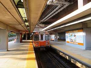 A northbound train at Sullivan Square station in July 2019 | |||||||||||
| Location | Maffa Way and Cambridge Street Charlestown, Boston, Massachusetts | ||||||||||
| Coordinates | 42.384031°N 71.07697°W | ||||||||||
| Line(s) | Haymarket North Extension | ||||||||||
| Platforms | 2 island platforms | ||||||||||
| Tracks | 3 (Orange Line) 2 (commuter rail) | ||||||||||
| Connections | |||||||||||
| Construction | |||||||||||
| Parking | 222 spaces ($6.00 fee) | ||||||||||
| Bicycle facilities | 16 spaces | ||||||||||
| Disabled access | Yes | ||||||||||
| History | |||||||||||
| Opened | June 10, 1901 (elevated station) | ||||||||||
| Rebuilt | April 7, 1975 (modern station)[1] | ||||||||||
| Traffic | |||||||||||
| Passengers (FY2019) | 8,305 (weekday average boardings)[2] | ||||||||||
| Services | |||||||||||
| |||||||||||
Station layout
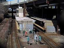
Sullivan Square station is located in an open cut under the Interstate 93 viaduct just west of the Sullivan Square traffic circle. The cut has seven tracks: two freight yard tracks (Yard 21, with the tracks called 3rd Iron and 4th Iron) on the west, three Orange Line rapid transit tracks in the center, and two tracks used by MBTA Commuter Rail Haverhill Line and Newburyport/Rockport Line trains on the east.[3][4][5] Only the west (southbound) and center (northbound) Orange Line tracks are used for revenue service; the unused east track, originally intended for express service, is only used for maintenance and testing. A pair of island platforms are located between the Orange Line tracks; the west platform serves trains in both directions, while the east platform serves only northbound trains.[4] The platforms have a "utilitarian" concrete design similar to Community College station.[6]:100
A mezzanine and fare lobby above the tracks is connected to the platforms with stairs, escalators, and elevators. The entrance is from the east side of the tracks, on the upper level of the two-level busway.[7][8] A passageway leads from outside the station entrance under the upper busway to the lower busway. East of the busways is a surface parking lot.[8]
| 3rd Iron | ← Freight use only → |
| 4th Iron | ← Freight use only → |
| Southbound (Track 1) | ← Orange Line toward Forest Hills (Community College) |
| Island platform | |
| Northbound (Track 2) | Orange Line toward Oak Grove (Assembly) → |
| Island platform (Not in regular service) | |
| Track 3 | No regular service |
| Commuter Rail (Track 2) | ← Haverhill Line, Newburyport/Rockport Line do not stop here → |
| Commuter Rail (Track 1) | ← , Haverhill Line, Newburyport/Rockport Line do not stop here → |
History
Railroad stations
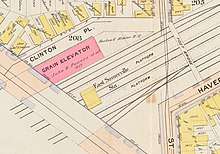
The Boston and Maine Railroad (B&M) opened its new mainline just west of Sullivan Square on July 1, 1845. The parallel Grand Junction Railroad and Depot Company opened in 1849; passenger service on that line began on April 10, 1854 as the Eastern Railroad's entrance to Boston.[9]:75 By 1875, the B&M's East Somerville station was located on the north side of Cambridge Street, with the Eastern's Somerville station on the south side.[10][11] The B&M acquired the Eastern in 1885 and initially continued to use both stations.[12][9]:75 In the 1890s, the B&M replaced the separate stations with a consolidated East Somerville station.[12][13] The station building was located over the tracks on the north side of Cambridge Street; two island platforms were reached by stairs from the station building and from a footbridge at Perkins Street.[13][14]
The station building was closed in 1927 and soon demolished; in February 1932, with just a few trains a day stopping, the railroad successfully petitioned the Public Utilities Commission to abandon the station entirely.[15][16] However, the station remained in use, served by a small number of trains on both the Eastern Division and Western Division.[17] On April 18, 1958, the Boston and Maine Railroad received permission from the Public Utilities Commission to drastically curtail its suburban commuter service, including abandoning branches, closing stations, and cutting trains. Among the approved cuts was the closure of all Eastern Division service south of Lynn, including the Saugus Branch plus mainline stations at East Somerville, Everett, Chelsea, and Forbes.[18] The Saugus Branch and mainline stations were closed on May 16, 1958.[9][19]
Elevated station
Sullivan Square and its station are named for James Sullivan, an early 19th-century Governor of Massachusetts[20] and first president of the Middlesex Canal Co. A plaque commemorating the canal is on the column right of the entrance to the station.
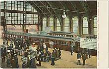
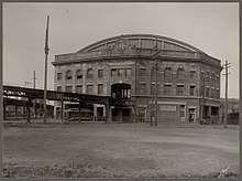
The first rapid transit station at Sullivan Square opened on June 10, 1901 as part of the Charlestown Elevated rapid transit line, a predecessor to the modern Orange Line. The original elevated station was considered a crown jewel of the "El", along with a similar station complex at Dudley Square in Roxbury. Surface streetcars ran up to 10 stub-end tracks at the level of the elevated stations, allowing cross-platform transfer underneath an expansive trainshed.[21]:21 The station was designed as a major transfer point, with many streetcar lines that had gone downtown truncated to Sullivan. Lexington and Boston Street Railway cars from as far away as Lowell ran to Sullivan Square until May 4, 1912, when they were redirected to Harvard station.[22]
Over time, deferred maintenance on the Charlestown Elevated and Sullivan Square station took its toll. A large fire also caused significant damage to the station's upper level on November 1, 1967.[23] The Haymarket North Extension was constructed in the early 1970s along the Haverhill Line right-of-way, with a relocated new Sullivan Square station under the elevated I-93 expressway.[24] The Charlestown Elevated closed on April 4, 1975; the Haymarket North Extension opened as far as Sullivan Square on April 7. The new Sullivan station was the terminus of the extension for five months until Wellington opened on September 6, 1975.[1]
There were proposals to renovate the cavernous old trainshed for use as retail or gallery spaces, but no such conversion took place; the massive structure was subsequently razed in 1975[25] and repurposed as an MBTA service vehicle parking lot.[26] Only supports for a footbridge crossing the traffic circle remain of the elevated station. A similar structure at the Dudley Square station on the Orange Line was carefully preserved, lowered to ground level, and reopened in 1993 as a major bus transfer station.
Sullivan station was not originally accessible. Construction of elevators at Sullivan and Wellington took place in 1991–92.[27][28][29]
Plans
Sullivan Square station was a proposed stop on the MBTA's planned Urban Ring Project.[30] The Urban Ring was to be a circumferential bus rapid transit (BRT) line designed to connect the current MBTA Lines to reduce strain on the downtown transfer stations. Plans from 2008 also called for the addition of platforms to serve the adjacent Haverhill and Newburyport/Rockport commuter rail lines.[31] The project was cancelled in 2010.[32]
The MBTA plans to add three elevators to the station, including an elevator to the lower busway. The work will also include replacement of the existing elevators, and two footbridges to connect the new elevators. A design contract was awarded in April 2020.[33]
Bus connections
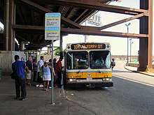
Sullivan Square has long been a major transfer point for surface transit. The original elevated station had surface and elevated streetcar loops to serve a number of BERy and Eastern Massachusetts Street Railway lines. The modern station has a two-level busway that serves 13 MBTA bus routes to Medford, Everett, Malden and other surrounding cities:
- 86: Sullivan Square station–Reservoir station
- 89: Clarendon Hill or Davis station–Sullivan Square station
- 90: Davis station–Assembly Row
- 91: Sullivan Square station–Central Square, Cambridge
- 92: Sullivan Square station–Downtown via Main Street
- 93: Sullivan Square station–Downtown via Bunker Hill Street
- 95: West Medford or Arlington Center–Sullivan Square station
- 101: Malden Center station–Sullivan Square station via Winter Hill
- 104: Malden Center station–Sullivan Square station via Ferry Street
- 105: Malden Center station–Sullivan Square station via Newland Street Housing
- 109: Linden Square–Sullivan Square station
- 194: Clarendon Hill–Haymarket station
- CT2: Sullivan Square station–Ruggles station
References
- Belcher, Jonathan. "Changes to Transit Service in the MBTA district" (PDF). NETransit.
- "A Guide to Ridership Data". MassDOT/MBTA Office of Performance Management and Innovation. June 22, 2020. p. 7.
- Held, Patrick R. (2010). "Massachusetts Bay Colony Railroad Track Charts" (PDF). Johns Hopkins Association for Computing Machinery. p. 9. Archived from the original (PDF) on October 8, 2013.
- "Ridership and Service Statistics" (PDF) (14th ed.). Massachusetts Bay Transportation Authority. 2014.
- "Figure II-4". Final Environmental Impact Statement: Red Line Extension – Harvard Square to Arlington Heights. 1. Urban Mass Transportation Administration – via Internet Archive.
- Elder, Andrew; Fox, Jeremy C. (2013). Boston's Orange Line. Arcadia Publishing. ISBN 9781467120470.
- "Sullivan Square Busway and Parking Lot Reconstruction". Massachusetts Bay Transportation Authority. 2019.
- "Sullivan Square Traffic Improvements" (PDF). Massachusetts Bay Transportation Authority.
- Humphrey, Thomas J.; Clark, Norton D. (1985). Boston's Commuter Rail: The First 150 Years. Boston Street Railway Association. p. 77. ISBN 9780685412947.
- "Plate L: Part of Ward 22, Boston". Atlas of the county of Suffolk, Massachusetts. 6. G.M. Hopkins & Co. 1875. pp. 52, 53 – via Norman B. Leventhal Map Center.
- "Plate F: Part of Ward 4, Charlestown". Atlas of the city of Boston. 6. G.W. Bromley & Co. 1885 – via Norman B. Leventhal Map Center.
- "Plates 19–20". Atlas of the City of Boston. 10. G.W. Bromley & Co. 1892 – via Norman B. Leventhal Map Center.
- "Plate 19: Part of Ward 4, Charlestown". Atlas of the city of Boston: Charlestown. G.W. Bromley & Co. 1901 – via Norman B. Leventhal Map Center.
- "East Somerville station, Somerville Mass. looking towards Boston". Harry A. Frye Collection. Boston & Maine Railroad Historical Society. c. 1910.
- "B. & M. WANTS TO ABANDON STATIONS: One at East Somervile in List of Three". Daily Boston Globe. February 12, 1932. p. 20 – via Newspapers.com.

- "Authority to abandon East Somerville station". Daily Boston Globe. March 26, 1932. p. 2 – via Newspapers.com.
- Form 5: Haverhill–Lawrence–Boston (timetable), Boston and Maine Railroad, July 8, 1956
- "Drastic Service Cuts Approved on Five B.& M. Divisions". Daily Boston Globe. 19 April 1958. p. 11 – via Newspapers.com.
- "B.&M. Closes Saugus Branch, 3 Other Lines". Daily Boston Globe. May 17, 1958. p. 3 – via Newspapers.com.
- "James Sullivan (1744-1808)". mass.gov. James Sullivan (1744-1808). 2013. Retrieved 6 December 2013.
- Cudahy, Brian J. (1972). Change at Park Street Under: The Story of Boston's Subways. Brattleboro, Vermont, US: Stephen Greene Press. ISBN 0-8289-0173-2.
- "Change in Car Route". Boston Globe. May 3, 1912. p. 1 – via Newspapers.com.
- "This Time in History". Rollsign. Vol. 54 no. 11/12. Boston Street Railway Association. November–December 2017. p. 15.CS1 maint: date format (link)
- City of Boston Department of Transportation. "Rutherford Avenue / Sullivan Square Design Project". cityofboston.gov/. City of Boston. Retrieved 6 December 2013.
- "Main Line Elevated Photos". CelebrateBoston. CelebrateBoston.com. Retrieved 2016-02-16.
- "Sullivan Square: Part 3 of 3". Somerville Development Forum. Somerville Development Forum. Retrieved 6 December 2013.
- Sanborn, George M. (1992). A Chronicle of the Boston Transit System. Massachusetts Bay Transportation Authority. Archived from the original on October 2, 2015 – via Massachusetts Institute of Technology.
- TranSystems and Planners Collaborative (August 24, 2007). "Evaluation of MBTA Paratransit and Accessible Fixed Route Transit Services: Final Report" (PDF). Massachusetts Bay Transportation Agency.
- MBTA : ACCESS; The Guide to Accessible Services and Facilities. Massachusetts Bay Transportation Authority. June 1992. p. 13 – via Internet Archive.
- Urban Ring Phase 2 Archived 2011-07-08 at the Wayback Machine. Massachusetts Executive Office of Transportation.
- Urban Ring Phase 2 Plan Profile Drawings. Massachusetts Executive Office of Transportation.
- Mullan, Jeffery B. (January 22, 2010). "Re: Urban Ring Phase 2, EOEEA #12565" (PDF). Massachusetts Executive Office of Energy and Environmental Affairs.
- Schwarz, John (April 13, 2020). "MBTA Contract Nos. A90PS02, A90PS04, & A90PS05: Architectural and Engineering Services for Station and Accessibility Improvements" (PDF). Massachusetts Bay Transportation Authority.
External links
| Wikimedia Commons has media related to Sullivan Square station. |