Longwood station (MBTA)
Longwood is a light rail stop on the MBTA Green Line D branch, located on Chapel Street in Brookline, Massachusetts, just north of Longwood Avenue. It serves the western end of the Longwood Medical Area, the Colleges of the Fenway, and residential areas of Brookline. The station opened with the rest of the line on July 4, 1959.[1] After renovation work completed in 2009, Longwood station is fully handicapped accessible from both Chapel Street and Riverway Park.
Longwood | |||||||||||||
|---|---|---|---|---|---|---|---|---|---|---|---|---|---|
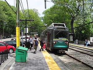 An outbound train at Longwood station in May 2011 | |||||||||||||
| Location | Chapel Street Brookline, Massachusetts | ||||||||||||
| Coordinates | 42°20′30″N 71°06′36″W | ||||||||||||
| Owned by | MBTA | ||||||||||||
| Line(s) | Highland Branch | ||||||||||||
| Platforms | 2 side platforms | ||||||||||||
| Tracks | 2 | ||||||||||||
| Construction | |||||||||||||
| Parking | 11 spaces | ||||||||||||
| Bicycle facilities | 15 spaces | ||||||||||||
| Disabled access | Yes | ||||||||||||
| History | |||||||||||||
| Opened | July 4, 1959[1] | ||||||||||||
| Rebuilt | 2007-2009 | ||||||||||||
| Traffic | |||||||||||||
| Passengers (2011) | 2,719 (weekday average boardings)[2] | ||||||||||||
| Services | |||||||||||||
| |||||||||||||
| |||||||||||||
History
Original stations
The Boston and Worcester Railroad opened a 1.4-mile (2.3 km) branch from Brookline Junction to Brookline on April 10, 1848.[3] There was one intermediate stations on the branch - Longwood just south of Longwood Avenue.[4] The Charles River Branch Railroad extended the Brookline Branch to Newton Upper Falls in November 1852 and to Needham in June 1853, keeping the original B&W station for its service.[3][4]
The Sears Chapel was built in 1861 and the Church of Our Savior in 1868; sometime that decade Chapel station was opened as a flag stop located at Carlton Street.[5][6] The Boston and Albany Railroad bought back the line, then part of the New York and New England Railroad, in February 1883. It was double-tracked and extended to the B&A main at Riverside; "Newton Circuit" service via the Highland Branch and the main line began on May 16, 1886.[3]
Station consolidation
%2C_circa_1893.jpg)
As part of a general improvement program, the railroad replaced many of its original wooden stations with new stone buildings designed by H.H. Richardson and Shepley, Rutan and Coolidge and landscaped by Frederick Law Olmsted. All stations on the Highland Branch save for Longwood, Chapel, and Brookline were thus rebuilt between 1883 and 1894.[7]
In April 1892, the B&A petitioned the Massachusetts Board of Railroad Commissioners to allow them to combine the two old stations into a single new station between their location. The railroad cited the closeness of the two stations, their poor locations, and traffic losses due to the electrified trolley line opened on nearby Beacon Street in 1889. The board referenced the railroad's arguments, the assent of the Brookline selectmen, and an overwhelming majority of residents and passengers in favor of the consolidation when giving their assent.[6]
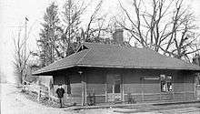
In early 1893, the B&A commissioned Shepley, Rutan and Coolidge to build new stations at Longwood and Riverside.[7] The new Longwood station was a "very simple rectangular design" with a dominant stone roof that provided shelter on all four sides. Located on Chapel Street near Hawes Street between the former station locations, it was constructed from July 1893 to May 1894.[7][8]
A footbridge at Carlton Street - one of the only steel bridges in an Olmsted-designed park, though it was designed and built by Brookline's town engineer - was added by the town in mid-1894 to provide access to the Riverway Park. The bridge was closed in 1975 due to severe corrosion.[9][10] Plans to repair and reopen the footbridge proved locally controversial for a number of years.[11] As of December 2019, construction of the $4 million project is expected to last from 2020 to 2022.[12]
Conversion to trolley service
In June 1957, the Massachusetts Legislature approved the purchase of the branch by the M.T.A. from the nearly-bankrupt New York Central Railroad for conversion to a trolley line. Service ended on May 31, 1958.[3] The line was quickly converted for trolley service, and the line including Longwood station reopened on July 4, 1959.[1] The 1893-built station was torn down during the conversion to make room for a small parking lot. The station has two side platforms serving the line's two tracks.
Renovations
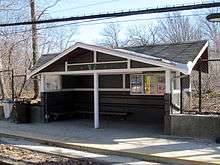
During the Brookline Village/Longwood Avenue Station Renovation Project, the MBTA renovated Longwood and Brookline Village stations for handicapped accessibility. The two stations received raised platforms to interface with low-floor trams, wooden ramps to access high-floor trams, and other upgrades. The MBTA originally planned to only offer handicapped access via the Chapel Street entrance to Longwood, but after it became apparent this was not sufficient, ramps were added from Riverway Park as well.[13][14] Work on both stations began on July 23, 2007.[15] Construction was completed in the second quarter of 2009, making Longwood station a fully handicapped accessible station.[16]
References
- Belcher, Jonathan. "Changes to Transit Service in the MBTA district" (PDF). NETransit.
- "Ridership and Service Statistics" (PDF) (14th ed.). Massachusetts Bay Transportation Authority. 2014.
- Humphrey, Thomas J.; Clark, Norton D. (1985). Boston's Commuter Rail: The First 150 Years. Boston Street Railway Association. pp. 21–24. ISBN 9780685412947.
- Karr, Ronald Dale (1995). The Rail Lines of Southern New England. Branch Line Press. pp. 277, 288–289. ISBN 0942147022.
- "Outline and Index Map of Brookline, Massachusetts". Atlas of The Town of Brookline 1874. G.M. Hopkins & Co. 1874 – via Ward Maps.
- Massachusetts Board of Railroad Commissioners (January 1893). Twenty-fourth Report of the Board of Railroad Commissioners. Wright and Potter Printing Company. pp. 147–149.
- Ochsner, Jeffrey Karl (June 1988). "Architecture for the Boston & Albany Railroad: 1881-1894". Journal of the Society of Architectural Historians. 47 (2). doi:10.2307/990324. JSTOR 990324.
- "Outline and Index Map of Brookline, Norfolk County, Massachusetts". Atlas of The Town of Brookline. G.M. Hopkins & Co. 1893 – via Ward Maps.
- "State transportation project: Carlton St. footbridge". Brookline Beacon. 9 November 2015. Retrieved 13 November 2015.
- Beveridge, Charles E. (25 September 2001). "Letter from Charles E. Beveridge to Gilbert Hoy" (PDF).
- Tuoti, Gerry (June 29, 2017). "Construction on Brookline's Carlton Street Footbridge scheduled to start soon". Wicked Local Brookline.
- "CARLTON STREET FOOTBRIDGE REHABILITATION: Status Report by Brookline DPW/Engineering Division" (PDF). December 9, 2019.
- "The MBTA Station Modernization Program" (PDF). Massachusetts Bay Transportation Authority. 23 September 2010. Retrieved 13 November 2015.
- "Accessiblity Improvements To Longwood Station" (Press release). Massachusetts Bay Transportation Authority. August 6, 2007.
- "Brookline Village Station and Longwood Station MBTA Contract No. A27CN02: Light Rail Accessibility Program, D-Line". Massachusetts Bay Transportation Authority. Archived from the original on 16 January 2008.
- "Access in Motion: 2009 Calendar" (PDF). Massachusetts Bay Transportation Authority. 2009. Archived from the original (PDF) on 2 January 2010.
External links
| Wikimedia Commons has media related to Longwood station (MBTA). |