Boston University Central station
Boston University Central is a surface-level light rail station on the MBTA Green Line B branch, located the center median of Commonwealth Avenue west of St. Marys Street in Boston, Massachusetts, surrounded by the Boston University campus. It consists of two side platforms, which serve the B branch's two tracks.
Boston University Central | |||||||||||||
|---|---|---|---|---|---|---|---|---|---|---|---|---|---|
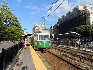 An outbound train at the station in July 2019 | |||||||||||||
| Location | Commonwealth Avenue at St. Marys Street Boston, Massachusetts | ||||||||||||
| Coordinates | 42.34989°N 71.106804°W | ||||||||||||
| Owned by | MBTA | ||||||||||||
| Platforms | 2 side platforms | ||||||||||||
| Tracks | 2 | ||||||||||||
| Connections | |||||||||||||
| Construction | |||||||||||||
| Disabled access | Yes | ||||||||||||
| History | |||||||||||||
| Opened | 1894[1] | ||||||||||||
| Rebuilt | March 18, 2002 - November 18, 2003[2][3] | ||||||||||||
| Previous names | St. Mary's Street | ||||||||||||
| Traffic | |||||||||||||
| Passengers (2011) | 2,194 (weekday average boardings)[4] | ||||||||||||
| Services | |||||||||||||
| |||||||||||||
| |||||||||||||
The station is accessible, with raised platforms to allow level boarding onto low-floor trams and a high platform on the inbound side to serve high-floor trams. Boston University Central is one of only five accessible surface stations on the "B" branch (the others are Boston University East, Harvard Avenue, Washington Street, and the branch's terminus at Boston College).[4]
History
The station has the third-highest ridership on the B branch (after only Harvard Avenue and Packards Corner).[4] In the early 2000s, the MBTA modified key surface stops with raised platforms for accessibility. Portable lifts were installed at Boston University Central around 2000 as a temporary measure.[5][6] Construction at Boston University Central and Boston University East was part of a $32 million modification of thirteen B, C, and E branch stations. [7] During construction, an interim station with temporary platforms between the two stops was used.[2] Construction began on March 18, 2002, a week behind schedule due to delays in finishing up similar work at Harvard Avenue and Washington Street. The project was then expected to be completed within six months.[2]
However, poor weather and limited work periods (as most work could only be done during the four hours at night that no trains used the line) delayed the completion date first to December 2002, then March 2003.[8] The contractor informed the MBTA in early 2003 that they would be unable to complete the work; a new contractor was chosen in mid-2003, but work did not resume until September.[9] The stations were completed and reopened on November 18, 2003.[3]
Around 2006, the MBTA added a wooden mini-high platform on the inbound side, allowing level boarding on older Type 7 LRVs. These platforms were installed at eleven Green Line stations in 2006–07 as part of the settlement of Joanne Daniels-Finegold, et al. v. MBTA.[10][11]
Bus connections
Four MBTA bus routes have connections near the station:
- CT2: Sullivan Square station–Ruggles station
- 47: Central Square, Cambridge–Broadway station
- 57: Watertown Yard–Kenmore station
- 57A: Oak Square–Kenmore station
- 193: Watertown Yard–Haymarket station
Routes CT2 and 47 stop at Commonwealth Avenue at University Road (northbound) and Mountfort Street at Lenox Street (southbound) to the west of the station, and Park Drive at Beacon Street to the south. Routes 57 and 57A (plus the limited-service 193) stop on Commonwealth Avenue at Saint Mary's Street directly across from the station.[12]
References
- Engineering and Maintenance Department (1981). "History of subways, tunnels and elevated lines". Massachusetts Bay Transportation Authority. Retrieved 17 December 2016.
- "BU East, Central T Stop Construction Begins Monday". Daily Free Press. March 15, 2002. Retrieved December 13, 2016.
- "MBTA Accessibility Program Update On Green Line" (Press release). Massachusetts Bay Transportation Authority. November 7, 2003. Archived from the original on December 5, 2003.
- "Ridership and Service Statistics" (PDF) (14th ed.). Massachusetts Bay Transportation Authority. 2014.
- "Executive Summary" (PDF). Program of Mass Transportation. Boston Regional Metropolitan Planning Organization. January 2004. p. 2-9. Archived from the original (PDF) on February 20, 2012.
- "Subway Map" (PDF). Massachusetts Bay Transportation Authority. 2001. Archived from the original (PDF) on July 1, 2001.
- Rivera, Lydia (July 12, 2001). "The MBTA Continues Accessibility Program At Coolidge Corner Station". MBTA Press Releases. Massachusetts Bay Transportation Authority. Archived from the original on October 30, 2001.
- "T construction continues". Daily Free Press. February 7, 2003. Retrieved December 18, 2016.
- "T stops set for Nov. finish". Daily Free Press. September 22, 2016. Retrieved December 18, 2016.
- "Settlement Agreement" (PDF). Joanne Daniels-Finegold et al. v. MBTA. April 10, 2006. pp. 10–11.
- "Green Line Stations Upgraded to Improve Accessibility" (PDF). TRANSReport. Boston Regional Metropolitan Planning Organization. June 2007. Archived from the original (PDF) on January 16, 2011.
- "Boston University Central Station Neighborhood Map" (PDF). Massachusetts Bay Transportation Authority. October 2012. Retrieved 22 November 2015.
External links
| Wikimedia Commons has media related to Boston University Central station. |