Stanghella
Stanghella is a comune (municipality) in the Province of Padua in the Italian region Veneto, located about 60 kilometres (37 mi) southwest of Venice and about 35 kilometres (22 mi) southwest of Padua. As of 31 December 2004, it had a population of 4,474 and an area of 19.7 square kilometres (7.6 sq mi).[3]
Stanghella | |
|---|---|
| Comune di Stanghella | |
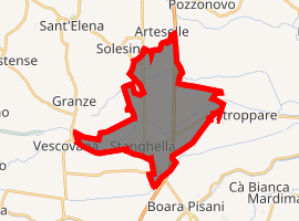
Location of Stanghella 
| |
 Stanghella Location of Stanghella in Italy  Stanghella Stanghella (Veneto) | |
| Coordinates: 45°8′N 11°45′E | |
| Country | Italy |
| Region | Veneto |
| Province | Province of Padua (PD) |
| Area | |
| • Total | 19.7 km2 (7.6 sq mi) |
| Population (Dec. 2004)[2] | |
| • Total | 4,474 |
| • Density | 230/km2 (590/sq mi) |
| Time zone | UTC+1 (CET) |
| • Summer (DST) | UTC+2 (CEST) |
| Postal code | 35048 |
| Dialing code | 0425 |
Stanghella borders the following municipalities: Boara Pisani, Granze, Pozzonovo, Solesino, Vescovana.
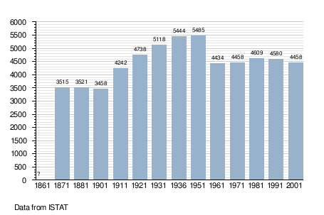
Demographic evolution

Twin towns
Stanghella is twinned with:

gollark: For the rogue/warrior/mage one, say, you can define all of it in terms of Cartesian X/Y or your apious space-filling curve, but it's convenient if you treat it as three separate levels of mageness, warriorness and rogueness which add to 1 or something.
gollark: But, like with cubical coordinates for hex grids, the third dimension is more convenient when doing some things.
gollark: They don't have three... I think the word is linearly independent dimensions, no.
gollark: Initiating orbital dimensionality reduction strike against Fiona.
gollark: The triangles could reasonably be considered 0 (not actually linear axes), 1 (just one... unit of data?), 2 (they exist in 2D) or 3 (they can vary in three directions, but not freely).
References
- "Superficie di Comuni Province e Regioni italiane al 9 ottobre 2011". Istat. Retrieved 16 March 2019.
- "Popolazione Residente al 1° Gennaio 2018". Istat. Retrieved 16 March 2019.
- All demographics and other statistics: Italian statistical institute Istat.
This article is issued from Wikipedia. The text is licensed under Creative Commons - Attribution - Sharealike. Additional terms may apply for the media files.