Loreggia
Loreggia is a comune (municipality) in the Province of Padua in the Italian region Veneto, located about 35 kilometres (22 mi) northwest of Venice and about 20 kilometres (12 mi) northeast of Padua.
Loreggia | |
|---|---|
| Comune di Loreggia | |
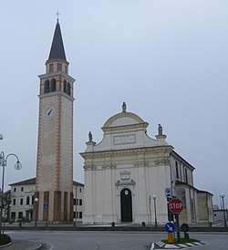 Parish church. | |
Location of Loreggia 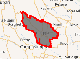
| |
 Loreggia Location of Loreggia in Italy  Loreggia Loreggia (Veneto) | |
| Coordinates: 45°36′N 11°57′E | |
| Country | Italy |
| Region | Veneto |
| Province | Padua (PD) |
| Frazioni | Loreggiola |
| Government | |
| • Mayor | Fabio Bui |
| Area | |
| • Total | 19.0 km2 (7.3 sq mi) |
| Elevation | 26 m (85 ft) |
| Population (30 September 2017)[2] | |
| • Total | 7,670 |
| • Density | 400/km2 (1,000/sq mi) |
| Demonym(s) | Loreggiani |
| Time zone | UTC+1 (CET) |
| • Summer (DST) | UTC+2 (CEST) |
| Postal code | 35010 |
| Dialing code | 049 |
| Website | Official website |
Loreggia borders the following municipalities: Camposampiero, Castelfranco Veneto, Piombino Dese, Resana, San Martino di Lupari, Santa Giustina in Colle.
Twin towns — sister cities
Loreggia is twinned with:

gollark: * project
gollark: I think sinthorion is trying to sabotage the problems.
gollark: THAT'S IT! Slice the toast into extremely small pieces and toast them individually, then reassemble it!
gollark: You'll need to accelerate the rest of the planet.
gollark: Well, if you accelerate the bread it experiences less time, we want the opposite.
References
- "Superficie di Comuni Province e Regioni italiane al 9 ottobre 2011". Istat. Retrieved 16 March 2019.
- All demographics and other statistics: Italian statistical institute Istat.
| Authority control |
|
|---|
This article is issued from Wikipedia. The text is licensed under Creative Commons - Attribution - Sharealike. Additional terms may apply for the media files.