Cartura
Cartura is a comune (municipality) in the Province of Padua in the Italian region Veneto, located about 40 kilometres (25 mi) southwest of Venice and about 15 kilometres (9 mi) south of Padua. As of 31 December 2004, it had a population of 4,268 and an area of 16.2 square kilometres (6.3 sq mi).[3]
Cartura | |
|---|---|
| Comune di Cartura | |
Location of Cartura 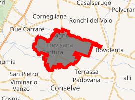
| |
 Cartura Location of Cartura in Italy  Cartura Cartura (Veneto) | |
| Coordinates: 45°16′9″N 11°51′28″E | |
| Country | Italy |
| Region | Veneto |
| Province | Province of Padua (PD) |
| Frazioni | Cagnola, Gorgo |
| Area | |
| • Total | 16.2 km2 (6.3 sq mi) |
| Population (Dec. 2004)[2] | |
| • Total | 4,268 |
| • Density | 260/km2 (680/sq mi) |
| Time zone | UTC+1 (CET) |
| • Summer (DST) | UTC+2 (CEST) |
| Postal code | 35025 |
| Dialing code | 049 |
The municipality of Cartura contains the frazioni (subdivisions, mainly villages and hamlets) Cagnola and Gorgo.
Cartura borders the following municipalities: Bovolenta, Casalserugo, Conselve, Due Carrare, Maserà di Padova, Pernumia, San Pietro Viminario, Terrassa Padovana.
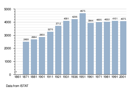
Demographic evolution
gollark: Orbital lasers MAY be used against ANY heretics for purposes.
gollark: > If god is omnipresent, and popes can directly communicate with god, and if god is willing to relay messages between popes, then by deploying popes strategically over large distances we can achieve faster than light communication via the holy spirit.Highly ideatic idea. What bandwidth do you estimate can be achieved with interpapal linking? Note that this PROBABLY would violate causality.
gollark: ™ by osmarks apiomathematicity™
gollark: I was programming for an arduino about 30 minutes ago for reasons, thus C++(ish), thus muahaahahaha.amajahans.
gollark: ddg! Sinthorionized apioformic thaumaturgy
References
- "Superficie di Comuni Province e Regioni italiane al 9 ottobre 2011". Istat. Retrieved 16 March 2019.
- "Popolazione Residente al 1° Gennaio 2018". Istat. Retrieved 16 March 2019.
- All demographics and other statistics: Italian statistical institute Istat.
This article is issued from Wikipedia. The text is licensed under Creative Commons - Attribution - Sharealike. Additional terms may apply for the media files.