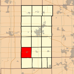
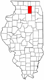
Shabbona Township, DeKalb County, Illinois
Shabbona Township is one of nineteen townships in DeKalb County, Illinois, USA. As of the 2010 census, its population was 1,453 and it contained 603 housing units.[2] The township contains the Chief Shabbona Forest Preserve and Shabbona Lake State Park.
Shabbona Township | |
|---|---|
 Location in DeKalb County | |
 DeKalb County's location in Illinois | |
| Coordinates: 41°45′37″N 88°53′04″W | |
| Country | |
| State | |
| County | DeKalb |
| Established | November 6, 1849 |
| Area | |
| • Total | 35.18 sq mi (91.1 km2) |
| • Land | 34.59 sq mi (89.6 km2) |
| • Water | 0.59 sq mi (1.5 km2) 1.68% |
| Elevation | 889 ft (271 m) |
| Population (2010) | |
| • Total | 1,453 |
| • Estimate (2016)[1] | 1,445 |
| • Density | 42/sq mi (16/km2) |
| Time zone | UTC-6 (CST) |
| • Summer (DST) | UTC-5 (CDT) |
| ZIP codes | 60518, 60530, 60550, 60556 |
| FIPS code | 17-037-68835 |
Geography
According to the 2010 census, the township has a total area of 35.18 square miles (91.1 km2), of which 34.59 square miles (89.6 km2) (or 98.32%) is land and 0.59 square miles (1.5 km2) (or 1.68%) is water.[2] The township is named after the Potawatomi tribal leader, Chief Shabbona.
Unincorporated towns
(This list is based on USGS data and may include former settlements.)
Cemeteries
- Old English
- Smith
- Lee Calvary
- Rose Hill
School districts
- Indian Creek Community Unit District 425
Political districts
- Illinois's 14th congressional district
- State House District 70
- State Senate District 35
gollark: The thing with kindles is that they're basically completely different to... well, most linuxes and androids.
gollark: I didn't mean Kindle Fires.
gollark: I wonder whether you could do anything useful with actual Kindles. I have one lying around; they run Linux with really weird configuration in some places.
gollark: I mean, mine does, given that it's a cheap Wileyfox one, but I don't actually have an SD card.
gollark: Sounds like I can't actually be bothered.
References
- "Shabbona Township, DeKalb County, Illinois". Geographic Names Information System. United States Geological Survey. Retrieved 4 July 2010.
- US Census Bureau 2009 TIGER/Line Shapefiles
- US National Atlas
- "Population and Housing Unit Estimates". Retrieved June 9, 2017.
- "Population, Housing Units, Area, and Density: 2010 - County". US Census Bureau. Archived from the original on 12 February 2020. Retrieved 28 May 2013.
- "Census of Population and Housing". Census.gov. Retrieved June 4, 2016.
External links
This article is issued from Wikipedia. The text is licensed under Creative Commons - Attribution - Sharealike. Additional terms may apply for the media files.