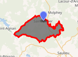
Saint-Didier, Côte-d'Or
Saint-Didier is a commune in the Côte-d'Or department in eastern France.
Saint-Didier | |
|---|---|
Location of Saint-Didier 
| |
 Saint-Didier  Saint-Didier | |
| Coordinates: 47°19′50″N 4°11′01″E | |
| Country | France |
| Region | Bourgogne-Franche-Comté |
| Department | Côte-d'Or |
| Arrondissement | Montbard |
| Canton | Semur-en-Auxois |
| Government | |
| • Mayor (2008–2014) | Didier Dupuis |
| Area 1 | 21.14 km2 (8.16 sq mi) |
| Population (2017-01-01)[1] | 207 |
| • Density | 9.8/km2 (25/sq mi) |
| Time zone | UTC+01:00 (CET) |
| • Summer (DST) | UTC+02:00 (CEST) |
| INSEE/Postal code | 21546 /21210 |
| Elevation | 420–617 m (1,378–2,024 ft) (avg. 506 m or 1,660 ft) |
| 1 French Land Register data, which excludes lakes, ponds, glaciers > 1 km2 (0.386 sq mi or 247 acres) and river estuaries. | |
Population
| Year | Pop. | ±% |
|---|---|---|
| 1962 | 226 | — |
| 1968 | 257 | +13.7% |
| 1975 | 204 | −20.6% |
| 1982 | 205 | +0.5% |
| 1990 | 174 | −15.1% |
| 1999 | 194 | +11.5% |
| 2008 | 208 | +7.2% |
gollark: I prefer technetium in general however.
gollark: What of the median Zirconium enjoyer?
gollark: Can Rust even represent lenses without HKTs?
gollark: That was misscheduled, you bee.
gollark: Hmm, I somehow failed to notice, but my laptop's WiFi card somehow ceased to exist.
See also
- Communes of the Côte-d'Or department
- Parc naturel régional du Morvan
References
- "Populations légales 2017". INSEE. Retrieved 6 January 2020.
| Wikimedia Commons has media related to Saint-Didier (Côte-d'Or). |
This article is issued from Wikipedia. The text is licensed under Creative Commons - Attribution - Sharealike. Additional terms may apply for the media files.