Arcenant
Arcenant is a French commune in the Côte-d'Or department in the Bourgogne-Franche-Comté region of eastern France.
Arcenant | |
|---|---|
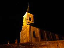
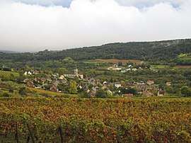 A general view of Arcenant | |
.svg.png) Coat of arms | |
Location of Arcenant 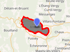
| |
 Arcenant  Arcenant | |
| Coordinates: 47°08′25″N 4°50′48″E | |
| Country | France |
| Region | Bourgogne-Franche-Comté |
| Department | Côte-d'Or |
| Arrondissement | Beaune |
| Canton | Nuits-Saint-Georges |
| Government | |
| • Mayor (2008–2020) | Jean-Paul Sérafin |
| Area 1 | 10.12 km2 (3.91 sq mi) |
| Population (2017-01-01)[1] | 507 |
| • Density | 50/km2 (130/sq mi) |
| Time zone | UTC+01:00 (CET) |
| • Summer (DST) | UTC+02:00 (CEST) |
| INSEE/Postal code | 21017 /21700 |
| Elevation | 305–591 m (1,001–1,939 ft) (avg. 337 m or 1,106 ft) |
| 1 French Land Register data, which excludes lakes, ponds, glaciers > 1 km2 (0.386 sq mi or 247 acres) and river estuaries. | |
The inhabitants of the commune are known as Arcenantais or Arcenantaises[2]
Geography
Located in the Hautes-Côtes de Nuits, between Dijon and Beaune, Arcenant is 9 km west of Nuits-Saint-Georges and 16 km north of Beaune. Access to the commune is by the D25 road from Meuilley in the east passing through the village and continuing to join the D18 just west of the commune. The commune is heavily forested with some areas of farmland around the village and in the east.
The Raccordon rises west of the village and flows east through the village and on to join the Meuzin east of Meuilly.[3]
Neighbouring communes and villages[3]
Places adjacent to Arcenant | |
|---|---|
History
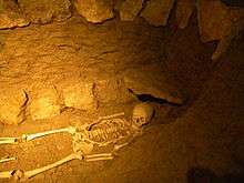
On 15 June 1944 German troops together with men from the French Milice attacked a hundred Maquis resistance fighters holed up in a place called La Grotte (The Cave). Fighting resulted in 39 dead attackers and 6 dead Maquis with 4 wounded. The six dead were: Serge Boillereau, Ferruccio Borillo, Louis Evrard, Jean Fiorese, Jean Poulet, and André Rebill. This feat of arms continues to be celebrated each year on the site of the battle.[4]
Administration
List of Successive Mayors[5]
| From | To | Name | Party | Position |
|---|---|---|---|---|
| 2001 | 2020 | Jean-Paul Sérafin |
(Not all data is known)
Demography
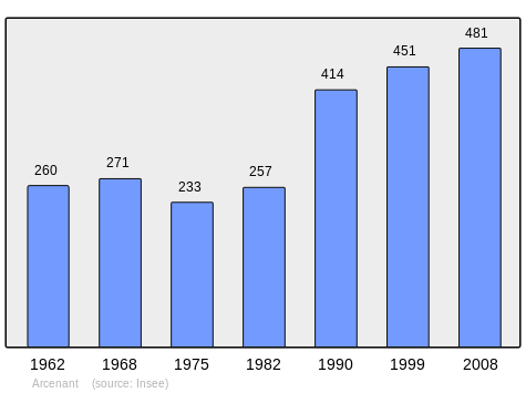
In 2009 the commune had 497 inhabitants. The evolution of the number of inhabitants is known from the population censuses conducted in the commune since 1793. From the 21st century, a census of communes with fewer than 10,000 inhabitants is held every five years, unlike larger towns that have a sample survey every year.[Note 1]
| 1793 | 1800 | 1806 | 1821 | 1831 | 1836 | 1841 | 1846 | 1851 |
|---|---|---|---|---|---|---|---|---|
| 380 | 392 | 430 | 420 | 491 | 542 | 547 | 549 | 559 |
| 1856 | 1861 | 1866 | 1872 | 1876 | 1881 | 1886 | 1891 | 1896 |
|---|---|---|---|---|---|---|---|---|
| 563 | 560 | 588 | 545 | 552 | 557 | 539 | 484 | 440 |
| 1901 | 1906 | 1911 | 1921 | 1926 | 1931 | 1936 | 1946 | 1954 |
|---|---|---|---|---|---|---|---|---|
| 445 | 416 | 378 | 305 | 318 | 301 | 270 | 278 | 271 |
| 1962 | 1968 | 1975 | 1982 | 1990 | 1999 | 2006 | 2009 | - |
|---|---|---|---|---|---|---|---|---|
| 260 | 271 | 233 | 257 | 414 | 451 | - | 497 | - |
Sites and monuments[6]
- The Trou du Duc (The Duke's Hole), a cave in the side of a cliff from which there is a beautiful view, inhabited since antiquity[7]
- The Puits à terre (Land Well), a well masoned similar to a conventional well but for collecting the soil from vines carried by the runoff water. There was enough remaining to restore in place.
- The Groseille well, a large underground chamber 560m across and 30m deep
- The Ecartelot Gallo-Roman site in the Arcenant communal forest. Located on a Roman road, it included a farm and a pool for drinking water, rare in Côte-d'Or.
- A Fortified Priory from the 13th century.
- A Tree of Liberty in the central square of the village.
- 3 Lavoirs (Public Laundries) (19th century)

- The Parish Church of Saint-Martin (14th century) contains several items that are registered as historical objects:
See also
External links
- Arcenant on the National Geographic Institute website (in French)
- Arcenant on Lion1906
- Arcenant on Géoportail, National Geographic Institute (IGN) website (in French)
- Arcenant on the 1750 Cassini Map
Notes and references
Notes
- At the beginning of the 21st century, the methods of identification have been modified by Law No. 2002-276 of 27 February 2002 Archived 6 March 2016 at the Wayback Machine, the so-called "law of local democracy" and in particular Title V "census operations" allows, after a transitional period running from 2004 to 2008, the annual publication of the legal population of the different French administrative districts. For communes with a population greater than 10,000 inhabitants, a sample survey is conducted annually, the entire territory of these communes is taken into account at the end of the period of five years. The first "legal population" after 1999 under this new law came into force on 1 January 2009 and was based on the census of 2006.
References
- "Populations légales 2017". INSEE. Retrieved 6 January 2020.
- Inhabitants of Côte-d'Or (in French)
- Google Maps
- Article in Bien Public of 26 June 2002, consulted on 25 December 2008. (in French)
- List of Mayors of France
- Article in Bien Public on 5 January 2006, consulted on 25 December 2008. (in French)
- Memoirs, Historical, Archaeological, and Literary Society of the Arrondissement of Beaune, Archaeological Society of Beaune (Côte d'Or), Impr. Beaunoise. 1910. p. 33, consulted on 25 December 2008. (in French)
- Ministry of Culture, Mérimée IA21000604 Lavoir IA21000603 Lavoir at Le Racordon IA21000602 Lavoir at Chevrey(in French)
- Ministry of Culture, Palissy PM21000050 Painting: Ecstasy of Saint Angèle Merici (in French)

- Ministry of Culture, Palissy PM21000049 Statue: Virgin and child (in French)
- Ministry of Culture, Palissy PM21000048 Group Sculpture: Charity of Saint Martin (in French)
- Ministry of Culture, Palissy IM21008596 All the Monumental Paintings in the Choir (in French)
| Wikimedia Commons has media related to Arcenant. |
| Authority control |
|
|---|