Richtenberg
Richtenberg (German: [ˈʁɪçtn̩ˌbɛʁk] (![]()
Richtenberg | |
|---|---|
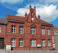 Town hall | |
 Coat of arms | |
Location of Richtenberg within Vorpommern-Rügen district 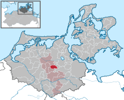 | |
 Richtenberg  Richtenberg | |
| Coordinates: 54°12′N 12°52′E | |
| Country | Germany |
| State | Mecklenburg-Vorpommern |
| District | Vorpommern-Rügen |
| Municipal assoc. | Franzburg-Richtenberg |
| Government | |
| • Mayor | Karldiether Wegner |
| Area | |
| • Total | 15.63 km2 (6.03 sq mi) |
| Elevation | 19 m (62 ft) |
| Population (2018-12-31)[1] | |
| • Total | 1,288 |
| • Density | 82/km2 (210/sq mi) |
| Time zone | CET/CEST (UTC+1/+2) |
| Postal codes | 18461 |
| Dialling codes | 038322 |
| Vehicle registration | NVP |
| Website | www.amt-franzburg-richtenberg.de |
Richtenberg was first mentioned in the founding document of the Neuenkamp monastery (today Franzburg) dated 8 November 1231. It is the oldest documented place in the region. In the foundation deed of the ruling Prince Wizlaw I, the monastery was awarded a patronage over the Richtenberg church as well as a local salt source.
References
- "Statistisches Amt M-V – Bevölkerungsstand der Kreise, Ämter und Gemeinden 2018". Statistisches Amt Mecklenburg-Vorpommern (in German). July 2019.
| Wikimedia Commons has media related to Richtenberg. |
| Authority control |
|
|---|
This article is issued from Wikipedia. The text is licensed under Creative Commons - Attribution - Sharealike. Additional terms may apply for the media files.