Prince Edward County, Ontario
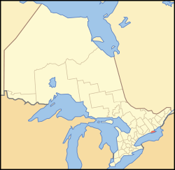
Prince Edward County (2016 census population 24,735[1]) is city, single-tier municipality and a census division of the Canadian province of Ontario.
Prince Edward | |
|---|---|
| County of Prince Edward | |
 | |
| Coordinates: 44°00′N 77°15′W | |
| Country | Canada |
| Province | Ontario |
| Settled | 1792 |
| Incorporated | 1998 |
| Government | |
| • Type | City |
| • Mayor | Steve Ferguson |
| • Federal riding | Bay of Quinte |
| • Prov. riding | Bay of Quinte |
| Area | |
| • Land | 1,050.45 km2 (405.58 sq mi) |
| Population (2016)[1] | |
| • Total | 24,735 |
| • Density | 24.0/km2 (62/sq mi) |
| Time zone | UTC-5 (EST) |
| • Summer (DST) | UTC-4 (EDT) |
| Postal Code | K0K |
| Area code(s) | 613 |
| Website | www.pecounty.on.ca |
History
Long settled by Indigenous peoples, the county has significant archeological sites. These include the LeVescounte Mounds of the Point Peninsula Complex people, built about 2000 years ago.
The county was created by Upper Canada's founding lieutenant-governor John Graves Simcoe on July 16, 1792.[2] It was named after Prince Edward Augustus, Duke of Kent (the fourth son of King George III) who was commander-in-chief of British North America.
Shortly after the American Revolution, the Crown made land grants to some of the earliest United Empire Loyalists to encourage their settlements in Ontario and provide compensation for property lost in the Thirteen Colonies. The county was originally composed of three townships named in honour of three of George III's daughters.
For many years Prince Edward County has been closely associated with the wholly mainland Hastings County. Its longtime militia unit has been The Hastings and Prince Edward Regiment (locally known as the Hasty Ps), whose most famous member was Farley Mowat. This noted nature author wrote And No Birds Sang, about his experiences with the Hasty Ps during the Second World War's Italian Campaign.
On January 1, 1998, the Town of Picton, the villages of Bloomfield and Wellington, and the townships of Ameliasburgh, Athol, Hallowell, Hillier, North Marysburgh, Sophiasburgh, and South Marysburgh amalgamated to form a new city with the official legal name of Prince Edward County.[3] Each of the former municipalities is now a ward.
Former municipalities
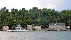
The following are former municipalities:[4]
- Ameliasburgh, named after Princess Amelia, youngest daughter of George III
- Athol
- Bloomfield
- Hallowell, named after Captain Benjamin Hallowell (1723-1799)), eminent Loyalist, formerly of Boston. He was the father-in-law of Chief Justice John Elmsley.
- Hillier, organized in 1823, and named after Major George Hillier, military secretary to Sir Peregrine Maitland.
- North Marysburgh, surveyed in 1785 and settled by Loyalist veterans, some of Hessian birth. Named for Princess Mary, Duchess of Gloucester and Edinburgh, one of George III's daughters.
- Sophiasburgh, named for Princess Sophia, one of George III's daughters. Surveyed in 1785 and 1787, settled by Loyalists from Nova Scotia and the Mainland.
- South Marysburgh, also named for Princess Mary, Duchess of Gloucester and Edinburgh, one of George III's daughters.
- Picton, named for Sir Thomas Picton
- Wellington, named after Arthur Wellesley, 1st Duke of Wellington
Geography
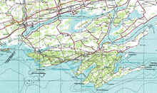
Prince Edward County is located in Southern Ontario on a large irregular headland or littoral at the eastern end of Lake Ontario, just west of the head of the St. Lawrence River. This headland (officially named Prince Edward County in 1792[5]) is surrounded on the north and east by the Bay of Quinte. As the Murray Canal now connects the bay to Lake Ontario across the only land connection, the county is technically an island. Murray Canal is crossed by 2 swing bridges, the single lane county road 64 bridge and the two lane country road 33 bridge. Bay of Quinte is crossed by two, 2-lane bridges of about 850m length - one carrying Provincial Highway 62 near Belleville and the other about 24 km east carrying Provincial Highway 49 near Deseronto.
Climate
The county's relatively mild humid continental climate (Dfb) due to the influence of Lake Ontario has led to the establishment of about 50 vineyards and close to 30 wineries; as a result Prince Edward County is one of Ontario's newest designated viticultural areas.[6] The lake effect from Lake Ontario results in heavier snowfall than in neighbouring counties.
| Climate data for Picton (1981−2010) | |||||||||||||
|---|---|---|---|---|---|---|---|---|---|---|---|---|---|
| Month | Jan | Feb | Mar | Apr | May | Jun | Jul | Aug | Sep | Oct | Nov | Dec | Year |
| Record high °C (°F) | 15.6 (60.1) |
12.0 (53.6) |
23.3 (73.9) |
29.5 (85.1) |
29.0 (84.2) |
34.5 (94.1) |
37.8 (100.0) |
34.4 (93.9) |
31.1 (88.0) |
26.0 (78.8) |
21.7 (71.1) |
16.1 (61.0) |
37.8 (100.0) |
| Average high °C (°F) | −2 (28) |
−1.0 (30.2) |
3.9 (39.0) |
11.1 (52.0) |
17.8 (64.0) |
22.4 (72.3) |
25.6 (78.1) |
24.3 (75.7) |
20.0 (68.0) |
13.5 (56.3) |
7.4 (45.3) |
1.4 (34.5) |
12.0 (53.6) |
| Daily mean °C (°F) | −6.4 (20.5) |
−5.6 (21.9) |
−0.6 (30.9) |
6.8 (44.2) |
13.0 (55.4) |
17.6 (63.7) |
21.0 (69.8) |
20.2 (68.4) |
16.0 (60.8) |
9.6 (49.3) |
4.1 (39.4) |
−2.4 (27.7) |
7.8 (46.0) |
| Average low °C (°F) | −10.9 (12.4) |
−10.2 (13.6) |
−5.1 (22.8) |
2.5 (36.5) |
8.2 (46.8) |
12.7 (54.9) |
16.4 (61.5) |
16.0 (60.8) |
11.9 (53.4) |
5.6 (42.1) |
0.8 (33.4) |
−6.2 (20.8) |
3.5 (38.3) |
| Record low °C (°F) | −36 (−33) |
−35.6 (−32.1) |
−27 (−17) |
−15.6 (3.9) |
−4.4 (24.1) |
0.6 (33.1) |
5.0 (41.0) |
3.3 (37.9) |
−0.6 (30.9) |
−7.2 (19.0) |
−18.9 (−2.0) |
−33 (−27) |
−36 (−33) |
| Average precipitation mm (inches) | 80.4 (3.17) |
77.1 (3.04) |
49.3 (1.94) |
84.4 (3.32) |
79.7 (3.14) |
74.3 (2.93) |
59.3 (2.33) |
76.3 (3.00) |
85.0 (3.35) |
80.9 (3.19) |
102.1 (4.02) |
94.4 (3.72) |
943.1 (37.13) |
| Average rainfall mm (inches) | 23.4 (0.92) |
23.2 (0.91) |
33.8 (1.33) |
79.8 (3.14) |
79.7 (3.14) |
74.3 (2.93) |
59.3 (2.33) |
76.3 (3.00) |
85.0 (3.35) |
80.5 (3.17) |
96.8 (3.81) |
48.8 (1.92) |
760.7 (29.95) |
| Average snowfall cm (inches) | 57.0 (22.4) |
53.9 (21.2) |
15.5 (6.1) |
4.6 (1.8) |
0.0 (0.0) |
0.0 (0.0) |
0.0 (0.0) |
0.0 (0.0) |
0.0 (0.0) |
0.39 (0.15) |
5.4 (2.1) |
45.7 (18.0) |
182.4 (71.8) |
| Average precipitation days (≥ 0.2 mm) | 12.9 | 10.9 | 9.2 | 11.3 | 12.4 | 11.4 | 8.5 | 10.4 | 11.9 | 13.1 | 13.1 | 13.4 | 138.4 |
| Average rainy days (≥ 0.2 mm) | 3.4 | 2.9 | 5.0 | 10.5 | 12.4 | 11.4 | 8.5 | 10.4 | 11.9 | 12.9 | 11.9 | 6.2 | 107.2 |
| Average snowy days (≥ 0.2 cm) | 10.0 | 8.1 | 4.5 | 1.0 | 0.0 | 0.0 | 0.0 | 0.0 | 0.0 | 0.23 | 1.6 | 7.5 | 32.9 |
| Source: Environment Canada[7] | |||||||||||||
Landscape
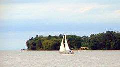
Prince Edward County is an island community encompassing approximately 1,000 square kilometres (390 sq mi), with over 500 kilometres (310 mi) of shoreline (including inland lakes and bordered by Lake Ontario) with beaches and limestone rich soil.
Communities
Prince Edward County includes the population centres of Picton and Wellington and the communities of Ameliasburg, Bloomfield, Carrying Place, Cherry Valley, Consecon, Cressy, Demorestville, Fawcettville, Glenora, Hillier, Lake On The Mountain, Milford, Mountain View, Northport, Rednersville, Rosehall, Rossmore, Salmon Point, Sophiasburgh, Waupoos, Waupoos Island, West Lake, Woodrous, and Yerexville.
Demographics
| Canada census – Prince Edward County, Ontario community profile | |||
|---|---|---|---|
| 2011 | 2006 | ||
| Population: | 25,258 (-0.9% from 2006) | 25,496 (2.4% from 2001) | |
| Land area: | 1,050.45 km2 (405.58 sq mi) | 1,050.14 km2 (405.46 sq mi) | |
| Population density: | 24.0/km2 (62/sq mi) | 24.3/km2 (63/sq mi) | |
| Median age: | 51.6 (M: 50.8, F: 52.2) | 47.7 (M: 47.1, F: 48.4) | |
| Total private dwellings: | 12,397 | 12,055 | |
| Median household income: | $53,287 | ||
| References: 2011[8] 2006[9] earlier[10] | |||
Population trend:[11]
- Population in 2011: 25,258
- Population in 2006: 25,496
- Population in 2001: 24,901
- Population in 1996: 25,046
- Ameliasburgh Township: 5571
- Athol Township: 1383
- Bloomfield Village: 687
- Hallowell Township: 4577
- Hillier Township: 1851
- North Marysburgh Township: 1312
- Picton Town: 4673
- Sophiasburgh Township: 2283
- South Marysburgh Township: 1018
- Wellington Village: 1691
- Population in 1991:
- Ameliasburgh Township: 5357
- Athol Township: 1416
- Bloomfield Village: 689
- Hallowell Township: 4349
- Hillier Township: 1804
- North Marysburgh Township: 1258
- Picton Town: 4386
- Sophiasburgh Township: 2110
- South Marysburgh Township: 968
- Wellington Village: 1426
Mother tongue:
- English as first language: 93.3%
- French as first language: 1.3%
- English and French as first language: 0.3%
- Other as first language: 5.1%
Attractions
Music festivals
Events include the Prince Edward County Chamber Music Festival in its 15th season which runs two weekends in the early fall with performances by internationally renowned Canadian musicians and features Canadian composers. The summer has the Classical Unbound Festival, with performances of classical music in unconventional venues and contexts by foremost Canadian musicians. Also in the summer is the renowned Jazz Festival which occurs in the month of August. Some of Canada's most prolific jazz musicians gather in the county for this festival. The Prince Edward County Country Jamboree happens in August in Cherry Valley. With over 40 Top Notch Canadian Country Music Entertainers over four days.
The 50s & 60s Rock N Roll Music Festival is held in Cherry Valley.
Vacationing
Prince Edward County has become a vacation destination with Sandbanks Provincial Park,[12] and Ontario's newest VQA wine Appellation[13] as the twin centrepieces of the tourism industry. Hotels, motels and bed & breakfast accommodations are abundant and mostly occupied during the summer months. In addition, many cottages are available such as those offered at Sandbanks Beach Resort.
Water activities
Prince Edward County's main water attractions are its white sand beaches. Together, Sandbanks Provincial Park, North Beach Provincial Park attract over 600,000 visitors yearly.[14] The numerous campgrounds throughout the County also allow many tourists to enjoy watersports such as those offered through Westlake Wakeboarding School, kayaking, canoeing, tubing, and more.
Skateboarding and BMXing
Beside the historic Crystal Palace is the County Youth Park. While the region is known for a large retirement community, young people now flock to the County to visit the skatepark and playground located in the corner of the Picton Fairgrounds property (which also holds the Picton Arena, the Prince Edward Curling Club & Crystal Palace).[15] For example, the YoungLife youth event "Road Rage" had teens of all ages visiting skateboard parks across Ontario and then entering their homemade skateboarding video into a contest; Picton was one of their stops.
Dining
Prince Edward County in recent years has become a top culinary destination, from the historic Black River Cheese Company which started operations in 1901 to the new LEED-certified, award-winning Fifth Town Artisan Cheese Factory.
The 'County' also holds the annual Great Canadian Cheese Festival.[16] This festival, held at the Picton Fairgrounds in June, boasts outstanding cheese-makers from all across Canada offering way more than 125 artisan cheeses for tasting and purchase. The festival also includes non-cheese related artisan foods such as, various breads and condiments, wine, cider and craft beer as well as many other offerings.
With an increasing number of cultural activities — in part due to the emigration of top artists and chefs to the area – like the "Taste" celebration or "Six Barrels for Six Chefs", the County has created a niche in the new Creative Economy. “It's yet another point of pride for Prince Edward County, which has become the gastronomic capital of Ontario — a fertile island bursting with vineyards, organic farms and a community of artists and chefs. Tucked into the "golden triangle" between Toronto, Montreal and Ottawa, it is the province's newest Designated Viticultural Area, which helps identify the origin of a wine and its grapes.” (The Globe and Mail)
Birding
Events also include the Spring Birding Festival;[17] Prince Edward County Authors' Festival; the County Jazz Festival, a summer event; the Prince Edward County Music Festival (a chamber music series) held on the same fall weekend as the Prince Edward County Studio and Gallery Tour; "Music at Port Milford," a summer music festival and school for string students from 12–18 years old, and an annual season of professional theatre produced by Festival Players of Prince Edward County.
Theatre
One of the few surviving art-deco movie houses in Ontario, Picton's downtown Regent Theatre, is host to a variety of plays, musicals and art movie screenings throughout the year. Prince Edward County has a live comedy scene with Taste That! producing regular improv and sketch comedy shows throughout the County since 2015, and the annual Comedy Country festival that pairs local acts with professional comedians from across Canada. The professional summer theatre company, Festival Players of Prince Edward County, provide a season of theatre for adults in July and August. Festival Players performs in their small 50-seat venue (The Studio Theatre) in the village of Wellington. There is a number of thriving community theatre groups in Prince Edward County. Prince Edward Community Theatre is a group specializing in plays ranging from the comedic to the deeply emotional, based mainly at Mount Tabor Playhouse in Milford. The Marysburgh Mummers is another group specializing more in children's shows and lighter materials for adults, prioritizing actors who have not yet had a chance to "tread the boards". Shatterbox Theatre is a volunteer-run theatre group that produces contemporary plays, primarily at The Regent Theatre. A drive-in movie theatre, The Mustang, is located north-west of Picton on Route 1.
Wineries, distilleries, and cider
Prince Edward County is home to many wineries, distilleries, and hard-cider companies. These include; Amanda's Vineyards, Black Prince Winery, Broken Stone Winery, Chadsey's Cairns Winery, Cape Winyard, Casa-Dea Estates Winery, Closson Chase Winery, County Cider Company, Del-Gatto Estates Ltd. Devils Wishbone Winery, Domaine Darius, Exultet Estates, Grange of Prince Edward Estate Winery, Gravel Hill Vineyards, Half Moon Bay Winery, Harwood Estate Wineyard, Hillier Creek Estates, Hinterland Wine Company, Hubbs Creek Vineyard, Huff Estates Winery, Karlo Estates, Keint-he Winery & Vineyard, Lacey Estates Winery, Lighthall Vineyards, Norman Hardie Winery, Rosehall Run, Sandbanks Winery, Stanners Vineyard, Sugarbush Vineyard, Thirty Three Vines Winery, Three Dog Winery, Trail Estate Winery, Traynor Family Vineyard, and Waupoos Estates Winery and Vineyard.[18]
Sports
Hockey
Driving south on Loyalist Highway 33 to the village of Wellington. Proudly displayed on billboards as you arrive in the small town of 1,700 — located 15 kilometers west of Picton in Prince Edward County — is ‘Home of the Dukes.’ Every season for the past dozen years the Wellington Dukes have finished at, or near the top of the II-tier league. “Parents of hockey-playing kids all over Ontario compete to send their kids to try out for the Dukes. Players aspiring for hockey scholarships to American universities, vie to play for the Dukes...”
Prince Edward Community Centre located at 375 Main Street is where the Picton Pirates [19] Junior C Hockey Team play their home games, Nicknamed the "Patcheyes", the Picton Pirates were founded in 1989 as members of the Eastern Ontario Junior C Hockey League.
Picton recently won the 2011 Empire "B" Junior C Championship after beating 2nd place Amherstview Jets 4-3 in the best of 7 and 1st place and defending champions Napanee Raiders in their best of seven series 4–2. In the spring of 2013, The Pirates became just the seventh team from Eastern Ontario since the 1930s to win the Ontario Hockey Association's Schmalz Cup, emblematic of Junior C supremacy in the province. The Pirates defeated the Essex 73's five games to one to capture the OHA title.
Sailing
Prince Edward County is surrounded by just over 500 km of shoreline offering a dozen or more sheltered harbors and many facilities that cater to boating are located throughout, including full-service marinas. The County has a rich sailing history which can be discovered at Mariners Park Museum[20] in South Marysburgh. For those interested in a broader collection of maritime material, Picton is also home to The Archives and Collections Society[21] which offers more than fifty thousand documents on the Great Lakes and the sea, maritime history and navigation.
The Prince Edward County Yacht Club located in Picton Harbour offers a junior sailing program for children aged 10–18 using monohull dinghies which sail out into the Bay of Quinte. PECYC uses CYA certified instructors and successful students are granted CYA certificates.
Government
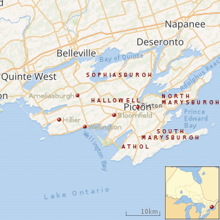 |
| Map of Prince Edward County, showing the towns, villages and townships of its ten wards.[22] |
Despite the official name, Prince Edward is not a county by the standard Ontario definition — it is a single-tier municipal government with city status that handles all municipal services. The former county seat and current council hall is located at the Shire Hall in Picton. Officially the area is the smallest single-tier municipality in Ontario, consisting of the merged governments of the original county and the 10 former towns, villages and townships which governed the area until 1997.
| Ward No. | Name |
|---|---|
| 1 | Picton |
| 2 | Bloomfield |
| 3 | Wellington |
| 4 | Ameliasburgh |
| 5 | Athol |
| 6 | Hallowell |
| 7 | Hillier |
| 8 | North Marysburgh |
| 9 | South Marysburgh |
| 10 | Sophiasburgh |
Education
Post-secondary
Prince Edward County is in close proximity to top educational institutions in Kingston and Belleville including Queen’s University, the Royal Military College of Canada, St. Lawrence College and Loyalist College.
Primary and secondary
The Hastings and Prince Edward District School Board serves close to 17,000 students each day at 46 elementary and eight secondary schools. The district covers a wide geographical area of 7,221 square kilometers bordered by Maynooth to the north, Deseronto to the east, Prince Edward County to the south and Quinte West to the west.
The Algonquin and Lakeshore Catholic District School Board serve students of the Roman Catholic faith. Approximately 15,000 students attend 36 elementary schools and 5 secondary schools in this school district
Sonrise Christian Academy is located at 58 Johnson St. in Picton and offers K-8 education from a Biblical worldview to families in Prince Edward County.
Previously the Prince Edward County Board of Education served the county.
List of area schools
Emergency services
The county is served by 1 EMS station of Hastings-Quinte EMS. Policing is provided from the Ontario Provincial Police detachment located in Picton.
Notable residents
- Al Purdy — Canadian poet, Purdy moved to Ameliasburgh in the 1950s.
- Kent Monkman - Painter and visual artist[23]
- Jamie Kennedy — Canadian chef and owner and operator of Jamie Kennedy Kitchens.
- Sir John A. Macdonald — First Canadian Prime Minister, lived for three years at Glenora, where his father operated a grist mill. In 1833, Macdonald returned to the Picton area to take over a law practice from his ailing cousin, Lowther P. Macpherson, who was in ill-health. During his stay here, Macdonald became the first secretary of the Prince Edward Young Men’s Society in 1834 and served as secretary of the Prince Edward District School Board. The latter position constituted his earliest experience in the field of public administration.
- Gord Downie — Lead singer of Canadian rock band The Tragically Hip is noted as saying during a concert in Belleville, Ontario that he has taken up occasional residence in the County.
- singer-songwriter Justin Rutledge,[24]
- flugelhornist Guido Basso
- author Janet Lunn
- artist and author Shani Mootoo[25]
- author J. D. Carpenter
- author John Oughton
- actor Anthony Lemke[26]
- folk opera composer Suzanne Pasternak
- theatre director Sarah Phillips
- potter Bill Reddick
- singer/songwriter Astrid Young[27]
- Raymond Myers Gorssline - 12th Canadian Surgeon General
- musical theatre writer and director Vincent de Tourdonnet
See also
- Royal eponyms in Canada
- List of Ontario census divisions
- List of townships in Ontario
Further reading
- Union Publishing Company Farmer's and Business Directory for the Counties of Frontenac, Hastings, Lennox, Addington, Prince Edward for 1899, Union Publishing Company, Ingersol, 1899 (facsimile reprint by Global Heritage Press, Milton, 2010)
- Elizabeth Hancocks and W. E. Britnell Prince Edward County Marriage Register 1858-69, Global Heritage Press, Milton, 2005
References
- "Census Profile, 2016 Census: Prince Edward County, City [Census subdivision], Ontario". Statistics Canada. Retrieved November 21, 2019.
- Ltd, Stormy Weather SoftWare. "Research - Various". Aandc.org. Retrieved 26 November 2017.
- Interim List of Changes to Municipal Boundaries, Status and Name From January 2, 1996 to January 1, 2001. Statistics Canada. January 2002. p. 220 of 419.
- Province of Ontario — A History 1615 to 1927 by Jesse Edgar Middleton & Fred Landon, copyright 1927, Dominion Publishing Company, Toronto.
- "The Evolution of the District and County System". Archived from the original on 2002-04-23.
- Vintners Quality Alliance
- "Picton". Canadian Climate Normals 1981–2010. Environment Canada. Retrieved September 22, 2013.
- "2011 Community Profiles". 2011 Canadian Census. Statistics Canada. July 5, 2013. Retrieved 2012-02-28.
- "2006 Community Profiles". 2006 Canadian Census. Statistics Canada. March 30, 2011. Retrieved 2012-02-28.
- "2001 Community Profiles". 2001 Canadian Census. Statistics Canada. February 17, 2012.
- Statistics Canada: 1996, 2001, 2006 census
- "Sandbanks Provincial Park". Canadian Geographic Magazine. March 1998. Archived from the original on September 23, 2015.
- "VQA Ontario · The Appellations · Prince Edward County". Vqaontario.ca. Retrieved November 26, 2017.
- "Park Statistics 2010" (PDF). Queen's Printer for Ontario. Archived from the original (PDF) on September 24, 2015.
- "Youth Park, Skateboarding & BMXing". Guide to Prince Edward County. Retrieved November 22, 2019.
- "Home - The Great Canadian Cheese Festival". The Great Canadian Cheese Festival. Retrieved 26 November 2017.
- "Spring Birding Festival". Peptbo.ca. Archived from the original on 2013-06-08. Retrieved 26 November 2017.
- "Wineries Archive - Prince Edward County Wineries". Prince Edward County Wineries. Retrieved 26 November 2017.
- Picton Pirates Archived 2010-08-08 at the Wayback Machine.
- "Mariners Park Museum, Prince Edward County". Stormy.ca. Retrieved 26 November 2017.
- "Naval Marine Archive - The Canadian Collection". Navalmarinearchive.com. Retrieved 26 November 2017.
- Restructured municipalities - Ontario map #5 (Map). Restructuring Maps of Ontario. Ontario Ministry of Municipal Affairs and Housing. 2006. Retrieved March 21, 2018.
- "Why First Nations visual artist Kent Monkman is ready for the country | CBC Arts".
- "Home". Justinrutledge.com. Retrieved 26 November 2017.
- "Shani Mootoo – Transatlantic Agency".
- "Anthony Lemke". IMDb.com. Retrieved 26 November 2017.
- "home". Astridyoung.net. Retrieved 26 November 2017.
External links
| Wikimedia Commons has media related to Prince Edward County, Ontario. |