Nunatsiavut
Nunatsiavut /nuːˈnɑːtsiəvʊt/ is an autonomous area claimed by Inuit in Newfoundland and Labrador, Canada. The region falls within the greater Canadian country of Inuit Nunangat. The settlement area includes territory in Labrador extending to the Quebec border. In 2002, the Labrador Inuit Association submitted a proposal for limited autonomy to the government of Newfoundland and Labrador. The constitution was ratified on 1 December 2005, at which time the Labrador Inuit Association ceased to exist, and the new Government of Nunatsiavut was established, initially being responsible for health, education and cultural affairs. It is also responsible for setting and conducting elections, the first of which was executed in October 2006. An election for the Ordinary Members of the Nunatsiavut Assembly was held on 4 May 2010.[1] The Nunatsiavut Assembly was dissolved on 6 April in preparation for the election.[2] Its incumbent president is Johannes Lampe who assumed office in 2016.
Nunatsiavut | |
|---|---|
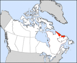 Nunatsiavut's location in Newfoundland and Labrador, Canada | |
| Country | Canada |
| Province | Newfoundland and Labrador |
| Created | 23 June 2005 |
| Capital | Hopedale (legislative) Nain (administrative) |
| Government | |
| • Type | Consensus government within the parliamentary system of Canada |
| • Body | Nunatsiavut katimajitsuangit |
| • President | Johannes Lampe (since 2016) |
| • First Minister | Tony Andersen (since 2019) |
| • MHA | Lela Evans (since 2019) |
| • MP | Yvonne Jones (since 2013) |
| Area | |
| • Resource rights | 72,520 km2 (28,000 sq mi) |
| • Officially | 15,800 km2 (6,100 sq mi) |
| Population (2011) | |
| • Resource rights | 2,617 |
| • Density | 0.03/km2 (0.08/sq mi) |
| Time zone | UTC-04 (AST) |
| Postal code prefix | A0P |
| ISO 3166 code | NL |
| Federal riding | Labrador (electoral district) |
| Provincial riding | Torngat Mountains (electoral district) |
| Website | nunatsiavut.com |

In Inuttitut/Inuktitut, Nunatsiavut means "Our Beautiful Land". This name was ratified by the Labrador Inuit Constitution and passed by the Labrador Inuit Association in 2002. A primary objective of autonomy is for the preservation of the Inuit culture and language, as well as the environment through environmental stewardship.
Nunatsiavut is counted in the census as Division 11.
Self-governance
The Labrador Inuit Association had filed a land claim for portions of Labradorian land in 1977.[3] In 1988, the Labrador Inuit Association, the government of Newfoundland and Labrador, and the government of Canada began negotiations based on the land claim.[4] An agreement-in-principle was achieved in 2001, and on 26 May 2004, the agreement was ratified by over 75% of eligible voters subject to the land claim.[4]
On 22 January 2005, the Inuit of Nunatsiavut signed the Labrador Inuit Lands Claims Agreement[5] with the federal and provincial governments covering 72,520 km2 (28,000 sq mi) of land,[3] including the entire northern salient of Labrador north of Nain as well as a portion of the Atlantic coast south of there. The agreement also includes 44,030 km2 (17,000 sq mi) of sea rights.[3] Although the Inuit will not own the whole area, they were granted special rights related to traditional land use, and they will own 15,800 km2 (6,100 sq mi) designated Labrador Inuit Lands.[3] The agreement also establishes the Torngat Mountains National Park Reserve in the northern area of the land claim.
The Labrador Inuit Lands Claims Agreement is a treaty between the Inuit of Labrador, the provincial government of Newfoundland and Labrador, and the federal government of Canada, that is constitutionally protected under the aboriginal and treaty rights of Aboriginal peoples in Canada granted by section 35 of the Constitution Act, 1982.[5]
The self-governance agreement included a transfer of $130 million from the federal Government of Canada in compensation for the forced relocation of the Inuit in the 1950s; $120 million to establish self-government; royalty payments from the provincial government for resource extraction; and land, mineral, and marine rights.[6] Unspecified benefits for Inuit in Labrador not within the settlement area were also part of the agreement.[3]
The agreement was ratified by the Labrador Inuit, the House of Assembly of Newfoundland and Labrador, and the Parliament of Canada, where it received Royal Assent on 23 June 2005.[7]
On 1 December 2005, the constitution was formally adopted, and a swearing-in ceremony was held for the first cabinet,[8] an interim government which consisted of members of the Labrador Inuit Association board of directors.[8] This day marked the official transfer of power from the provincial government to the newly formed Government of Nunatsiavut "to make their own laws relating to cultural affairs, education and health".[9]
In October 2006, Nunatsiavut held its first election to form a nine-member government, which was sworn in on 16 October in Hopedale.[10]
In 2019, there were 150 Inuit children in the care of the Department of Children, Seniors, and Social Development. An independent review, A Long Wait for Change, was completed by the province's Child and Youth Advocate at the request of the Nunatsiavut government and released in 2019. It contained 33 recommendations, including providing the support needed to transition to an Inuit-led child welfare system.[11]
Nunatsiavut Assembly and Executive Council
The land claim agreement provided for the establishment of the Government of Nunatsiavut to represent the residents of the land claim area and any Labrador Inuit living elsewhere in Canada. Nunatsiavut remained a part of Newfoundland and Labrador, but the Government of Nunatsiavut acquired the jurisdictional authority over health, education, and justice in the land claim area. Nunatsiavut operates under a consensus government within the parliamentary system of Canada.
The legislature of the government is based in Hopedale, and its administrative centre is in Nain. It is subject to the Nunatsiavut Elections Act. The Nunatsiavut Assembly consists of a minimum 16 members, including:
- a president, who chairs the Nunatsiavut Executive Council,[12]
- ten ordinary members[12] (one each from Hopedale, Makkovik, Postville and Rigolet;[13] two each from Nain, the Happy Valley-Goose Bay, Northwest River and Mud Lake area, and all Inuit elsewhere in Canada)
- the Angajukĸâk of each of the five Inuit Community Governments (one each in Nain, Hopedale, Postville, Makkovik and Rigolet)
- the Chairs of the Inuit Community Corporations.[12]
There are currently two Inuit Community Corporations, NunaKatiget Inuit Community Corporation and Sivunivut Inuit Community Corporation,[14] and 18 members in the Assembly.
From the Assembly, a member will be elected to act as First Minister. The Assembly would act as a forum for discussion of laws, and it will oversee the Executive Council.
The Nunatsiavut Executive Council will be appointed by the First Minister. It will implement laws, develop and implement policy, initiate and prepare legislation, oversee the administration of the government, and be accountable to the Assembly.
Inuit Community Governments were established in Nain, Hopedale, Makkovik, Postville and Rigolet. Each consists of a municipal council, elected from and by both Inuit and non-Inuit residents, and is led by an Angajukĸâk, a chief executive officer and mayor, who must be Inuk.
Large settlements of Labrador Inuit outside the settlement area will be represented by Inuit Community Corporations.
The Angajukĸâk of each Inuit Community Government and the chairperson of each Inuit Community Corporation will represent his or her community in the Nunatsiavut Assembly.
Departments
There are seven departments headed by 6 ministers with Nunatsiavut Secretariat headed by the President of the Executive Council.[15]
- Department of Finance, Human Resources and Information Technology
- Department of Education and Economic Development
- Department of Culture, Recreation and Tourism
- Department of Health & Social Development
- Department of Lands and Natural Resources
- Department of Nunatsiavut Affairs
- Nunatsiavut Secretariat
Government buildings
While each community has government facilities, there are two key sites:
Nunatsiavut Government Head Office is located at 25 Ikajuktauvik Road in Nain, NL and houses the administrative functions of the Government of Nunatsivut.
The Nunatsiavut Assembly sits at Nunatsiavut Assembly Building in Hopedale, Newfoundland and Labrador. The building opened in 2012 facing Hopedale Harbour[16] and is the first permanent home since 2008 (previous assemblies met at various locations in Hopedale).
Geography
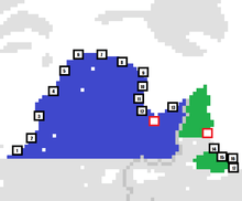
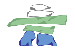
Largest communities in each territory are indicated by red squares (Nunainguk (Nain), NL and Kuujjuaq, QC)
Other communities:
Nunavik::
1. Kuujjuarapik
2. Umiujaq
3. Inukjuak
4. Puvirnituq
5. Akulivik
6. Ivujivik
7. Salluit
8. Kangiqsujuaq
9. Quaqtaq
10. Kangirsuk
11. Aupaluk
12. Tasiujaq
13. Kangiqsualujjuaq
Nunatsiavut:
14. Agvituk (Hopedale)
15. KipukKak (Postville)
16. Maggovik (Makkovik)
17. Tikigâksuagusik (Rigolet)
Nunatsiavut's land claim includes the area surrounding Hamilton Inlet and the coastline north to a point south of Davis Inlet; the Mulligan River also forms part of the boundary. It also claims the land north of the Notakwanon River and as far north as Cape Chidley. Nunatsiavut is the southernmost recognized Inuit territory in Canada.
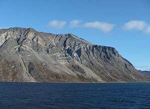
Nunatsiavut's territory consists of two geographic regions. The southern portion contains Rigolet, Makkovik, Postville and Hopedale and has a population of 1,403 (as of 2011).[17] The northern portion contains Nain as well as the Torngat Mountains National Park. Nunatsiavut is located near the Innu communities of Natuashish and Sheshatshiu as well as North West River, Happy Valley-Goose Bay and Cartwright. It is also near the Quebec settlements of Kuujjuaq and Kangiqsualujjuaq.
Land disputes
The Labrador Métis Nation (LMN) filed a challenge to Nunatsiavut's claim in the Supreme Court of Newfoundland. The federal government has also suggested that the LMN join Nunatsiavut. The LMN's original land claim included all of Labrador south of Nain.[18]
The Makivik Corporation had their claim to the coast between Killiniq Island and Voisey's Bay accepted in 1993 and later asked the federal government not to ratify Nunatsiavut's claims since it overlapped with their claim.[19]
Census Division No. 11
Division No. 11 | |
|---|---|
| Coordinates: 55°04′39″N 59°11′17″W | |
| Country | Canada |
| Province | Newfoundland and Labrador |
| Area | |
| • Total | 69,371.46 km2 (26,784.47 sq mi) |
| Population (2016)[20] | |
| • Total | 2,558 |
| • Density | 0.037/km2 (0.096/sq mi) |
Census Division No. 11 covers the Nunatsiavut area. Division 11 was used for the first time in the Canada 2006 Census; prior to 2006, Nunatsiavut was counted as part of Division 10.
The division had a population of 2,558 at the time of the Canada 2016 Census, down from 2,617 in the 2011 census.[20] It has a land area of 69,371.45 km2 (26,784.47 sq mi). It was the second least-populated census division in Canada in 2006; only British Columbia's Stikine Region was smaller.
Unorganized subdivisions
- Subdivision C
- Subdivision E
Demographics
Languages
Knowledge of official languages
| Canada Census Knowledge of official languages - Nunatsiavut, Newfoundland and Labrador[21][20] | ||||||||||||||||||
|---|---|---|---|---|---|---|---|---|---|---|---|---|---|---|---|---|---|---|
| Census | Total | English |
French |
French & English |
Other | |||||||||||||
| Year | Responses | Count | Pop % | Count | Pop % | Count | Pop % | Count | Pop % | |||||||||
2016 |
2,555 |
2,525 | 98.8% | 0 | 0% | 20 | 0.8% | 10 | 0.4% | |||||||||
2011 |
2,360 |
2,335 | 98.94% | 0 | 0.00% | 10 | 0.42% | 10 | 0.42% | |||||||||
Religion
According to the 2011 census, 98.73% of Nunatsiavut's residents identify as Christian. 11.25% identified as Anglican while 79.62% identified as "Other Christian" (most likely Moravian). 1.49% of Nunatsiavut's residents identified as having no religion.
Ethnic origin
According to the 2016 census, 90.23% of Nunatsiavut's residents claim Aboriginal ancestry.
Nunatsiavut grants enrollment to what it defines as 2 different ethnicities, the Inuit and the Kablunângajuit[22].
Inuit
Kablunângajuit
According to the Nunatsiavut government[23], somebody who is a Kablunângajuk (plural: Kablunângajuit) is "an individual who is given that designation according to Inuit customs and traditions". The Nunatsiavut government applies this designation to somebody who is either of mixed Inuit and non-Inuit descent or is not of Inuit descent but settled in what is now Nunatsiavut before 1940. Their ancestors were mainly fur traders from places such as Quebec, Scotland, Norway and elsewhere who often married Inuit spouses[24].
The term Kablunângajuk means "person who resembles a white person". They where historically called terms such as "settlers" or "half-breeds". It is also sometimes used to refer to the people of the unrecognized NunatuKavut region[25].
The Kablunângajuit are usually counted as Inuit by Statistics Canada so their exact population is unknown. As Nunatsiavut beneficiaries, they have all the same privileges as Inuit beneficiaries in the region.
Employment
9.81% of Nunatsiavut's population was unemployed in 2010.
Transportation
The MV Northern Ranger (owned by Nunatsiavut Marine Inc.) provides ferry service between Nunatsiavut's 5 communities as well as Natuashish, Happy Valley-Goose Bay, Cartwright and Black Tickle.[26] All 5 settlements also have airports with flights provided by Air Labrador and Provincial Airlines. No community in Nunatsiavut is road accessible; but there have been some proposals to connect Nunatsiavut to the Trans-Labrador Highway.[27][28]
Notable people
- Caubvick, namesake of Mount Caubvick
- Randy Edmunds, Member of the House of Assembly for Torngat Mountains (2011-2019)
- Johannes Lampe, 3rd President of Nunatsiavut (2016-)
- Sarah Leo, 2nd President of Nunatsiavut (2012–16)
- Natan Obed, President of the Inuit Tapiriit Kanatami
- Keith Russell, former Member of the House of Assembly for Lake Melville (2011–15), former provincial cabinet minister
- John Shiwak, soldier
- Abraham Ulrikab, former Hebron resident
- Mikak, one of the first Inuit to travel to, and return from, Europe in the mid 1700s.
See also
- Proposals for new Canadian provinces and territories
- Nunavut
- Nunavik
- Nunatukavut
References
- "Nunatsiavut General Election". Government of Nunatsiavut. Archived from the original on April 8, 2010. Retrieved April 22, 2010.
- "Nunatsiavut Assembly to be dissolved April 6" (Press release). Government of Nunatsiavut. March 18, 2010. Retrieved April 22, 2010.
- "Labrador's Inuit cheer land agreement". CBC News. January 23, 2005. Retrieved April 22, 2010.
- "Nunatsiavut: Our beautiful land". CBC News Online. July 2, 2004. Retrieved April 22, 2010.
- "Land Claims". Department of Labrador and Aboriginal Affairs, Government of Newfoundland and Labrador. Retrieved April 23, 2010.
- "Labrador Inuit to sign self-government deal". CBC News. January 21, 2005. Retrieved April 22, 2010.
- "Labrador Inuit land claim passes last hurdle". CBC News. June 24, 2005. Retrieved April 22, 2010.
- "Labrador's 5,000 Inuit take charge of 'our beautiful land'". CBC News. December 1, 2005. Retrieved April 22, 2010.
- . CBC News. December 1, 2005 https://web.archive.org/web/20070316181227/https://www.cbc.ca/canada/newfoundland-labrador/story/2005/12/01/nf_inuit_turnover_20051201.html. Retrieved April 22, 2010. Missing or empty
|title=(help) - "Labrador Inuit vote for inaugural self-government". CBC News. October 3, 2006. Retrieved April 22, 2010.
- "Assembly Structure". Nunatsiavut Assembly. Government of Nunatsiavut. Retrieved April 22, 2010.
- "Welcome to Rigolet". Town of Rigolet. Archived from the original on January 7, 2010. Retrieved June 4, 2010.
- "Inuit Community Governance". Government of Nunatsiavut. Retrieved April 22, 2010.
- "Departments". Nunatsiavut Government. Retrieved October 13, 2019.
- Fitzpatrick, Ashley (July 31, 2012). "Nunatsiavut building and rebuilding". NS Business Journal. Archived from the original on March 4, 2016.
- "Population and Dwelling Count Highlight Tables, 2011 Census". Statistics Canada. Retrieved October 13, 2019.
- Minogue, Sara (June 4, 2004). "Inuit, Métis at odds over Labrador land claim deal". Nunatsiaqonline.ca. Archived from the original on October 12, 2016.
- Green, Julie. "Makivik Corporation wants court to stop Labrador land claims". Nunatsiaq News. Archived from the original on October 12, 2016.
- "Census Profile, 2016 Census: Division No. 11, Census division [Census division], Newfoundland and Labrador". Statistics Canada. Retrieved October 13, 2019.
- "Census Profile - Division No. 11, Census division". Statistics Canada. Retrieved March 2, 2012.
- https://www.nunatsiavut.com/wp-content/uploads/2013/09/ApplicationBeneficiaryEnrollment2018.pdf
- https://www.nunatsiavut.com/wp-content/uploads/2013/09/Criteria-of-Beneficiary-Eligibility-and-Enrolment-Chapter-3.pdf
- http://www.labradorvirtualmuseum.ca/home/white_settlement.htm
- https://www.erudit.org/en/journals/etudinuit/2015-v39-n1-etudinuit02454/1036085ar/
- "Goose Bay - Rigolet - Ports North To Nain". Government of Newfoundland and Labrador. Retrieved October 13, 2019.
- "Inuit want road to northern Labrador". CBC News. July 29, 2009. Retrieved October 13, 2019.
- Way, Robert (October 29, 2015). "Is a road to Labrador's north coast feasible?". The Independent. Retrieved October 13, 2019.
- "(Code 1011) Census Profile". 2011 census. Statistics Canada. 2012.
External links
| Wikimedia Commons has media related to Nunatsiavut. |
| Wikivoyage has a travel guide for Nunatsiavut. |
- Government of Nunatsiavut
- Labrador and Inuit Land Claims Agreement at the Department of Labrador and Aboriginal Affairs of the Government of Newfoundland and Labrador
- Labrador Inuit Land Claims Agreement Implementation Plan at the Department of Labrador and Aboriginal Affairs of the Government of Newfoundland and Labrador
Places adjacent to Nunatsiavut | ||||||||||
|---|---|---|---|---|---|---|---|---|---|---|
| ||||||||||
| Census divisions | |
|---|---|
| Cities | |
| Other communities |
|
| |